
BACKGROUND:
This
short blog posting is merely to document my trek to a spot that provided a view
of several unnamed cascades along a gully that is located near the middle of
the Ammonoosuc Ravine on the west side of Mt. Washington. This place was visited merely on a hunch that
it might be a worthwhile adventure. No
reports had been read of others having ventured to this location. However, it is difficult to imagine that I am
the first visitor, especially since this viewpoint was reached by doing a short
bushwhack (about a tenth of a mile) northward from Gem Pool on the
heavily-traveled Ammonoosuc Ravine Trail.
Actually, the spot I visited and Gem Pool could be
considered as next door neighbors since they are in such close proximity to each other. :-)
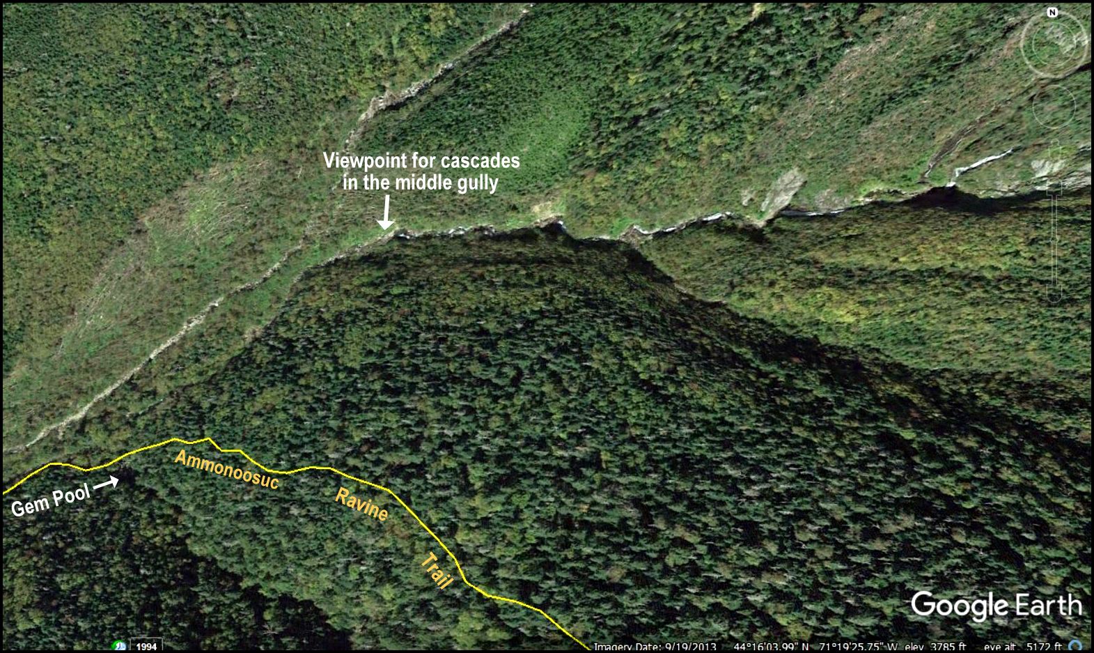 |
| Google Earth image showing location of the viewpoint in relation to Gem Pool and Ammonoosuc Ravine Trail |
This
trek took place in Sargent’s Purchase, NH in early September 2018.
It was launched from the Ammonoosuc Ravine Trail trailhead which is located
off the south side of Base Road. The
round-trip mileage was about 4.4 miles, of which 4.2 miles involved hiking the Ammonoosuc
Ravine Trail to/from Gem Pool. And, the remaining
distance involved a round-trip bushwhack of about 0.2 mile. The bushwhack was launched from the north
side of the brook that drains Gem Pool.
As
mentioned above, no name has ever been assigned to the cascades in the middle
gully of Ammonoosuc Ravine. For my
personal records, I’ve used an unofficial name of “Middle Gully Cascades”. Perhaps someday an official name will be
assigned to these attractive cascades.
PHOTOS:
 |
The above photo was taken from the bottom of a series of cascades located within a gully near the center of the Ammonoosuc Ravine. If you look closely near the center of the photo (just above the featured cascade), you can see two more cascades higher up on the wall of the ravine.
 |
This
composite photo shows zoomed views of two cascades located high up on the wall
of the Ammonoosuc Ravine (LEFT panel is slightly zoomed; RIGHT panel is highly
zoomed). These two cascades were not
visited on this particular day. They
will need to be the focus of a separate adventure. :-)
 |
| Shown above is yet another photo of the lower cascade. It was shot from a perspective that is different from the first photo shown in this posting. |
 |
| The above snapshot shows the view directly behind the cascade that was shown in the previous photo. In the distance are peaks in the Twin Range, plus a piece of Mt. Lafayette. |
 |
| And just as a refresher course :-), here is a snapshot of Gem Pool. It was taken just before launching my short tenth of a mile bushwhack to a gully near the middle of the Ammonoosuc Ravine. |
TO SUM IT UP:
Because
of my fondness for off-trail explorations, it somehow seems appropriate to sum
up this posting with one of my favorite quotes from J.R.R. Tolkien (author of ‘Lord of the Rings’) which states “Not all those who wander are lost.” :-)
8 comments:
Nice write up and photos as usual! I always wondered what was on that brook, because it always looked very scenic. I also never knew it was called "Gem Pool." It's always nice to read your shorter blogs!
-Evan
Hi Evan,
Thanks for your comments and your kind words.
Although my posting refers to the outflow from Gem Pool as a brook, I think it is actually the Ammonoosuc River at that point. However, at Gem Pool, it is definitely more brook-like in appearance. Further downstream, it becomes much more “river-like” in appearance after accumulating more water from a myriad of tributaries that flow into it.
All the best,
John
The pools, including Gem Pool, at the bottoms of the cascades look refreshing enough to be swimming holes. How deep are they? Tim would be wondering if they hold trout!
I love all the tumbling brooks, cascades and waterfalls in your part of the world! Thanks for posting.
Hi Rita . . . I don’t know how deep the pools are that I witnessed on this trek, but I would suspect they would only be no more than waist-deep.
And yes, New England is blessed with an abundance of beautiful tumbling brooks, cascades and waterfalls. Each region of the country has its own “brand” of beauty. I greatly admire the “brand” of beauty that abounds in your Far West region of the U.S.
John
Coming upon this nearly a year later. Don't know if you'll find this comment. Been enjoying your blog as an inspiration for hikes.
Do you know the curious slide one gully farther north than the one you discuss in this post? The slide is large, the shape of a spear tip and has a vivid stripe of vegetation down the middle. You can see it from around the Bretton Woods area. Here are the coordinates: 44.2704, -71.3217
Any knowledge or tips about getting to it?
TO:John Griesmer:
John, I have seen the slide that you described from various locations that I’ve visited in the area. However, I’ve never actually bushwhacked to it.
Don’t know of how much help the following might be, but am thinking that it MIGHT be helpful to you if I shared some of my waypoint info from my trek to “Gem Pool’s Next Door Neighbor”. So here goes:
44.2676, -71.3268 Point where I left the Ammo Ravine Trail
44.2678, -71.3267 Crossed a small brook not shown on topo maps
44.2679, -71.3268 Once on the other side of the brook mentioned above, I found a pathway leading NNE which took me to the mouth of my targeted gully.
Upon arrival at the mouth of my targeted gully, I could see the entrance to the gully that is of interest to you.
If you want to contact me via e-mail, please feel free to do so at randonneur8@yahoo.com
John
Guy Waterman named the central Ammonoosuc gully Koop's Kouloir, as he was first led up it by Allen Koop, professor of history at Dartmouth, who had made his first of about twenty-five scrambles along it from top to bottom while working on the Croo of the Lakes of the Clouds hut in the 1960s, wearing an apron!
Anonymous . . . thank you so much for sharing the info contained in the comment you posted.
Obviously, Allen must have found a way to navigate that couloir. It seemed pretty gnarly to me, but admittedly, I didn’t spend a lot of time trying to find a route to work my way further up the gully.
John
Post a Comment