
BACKGROUND:
In late
August 2018, I completed one of the many odd things on my ‘bucket-list’ of
things to do. This little adventure
involved climbing from the bottom to the top of Dryad Fall which is located
near Shelburne, New Hampshire.
Perhaps
one’s first thought might be that climbing from the bottom to the top of a
waterfall would generally not be such a big deal. However, it does become a bit of an adventure
when you consider that the estimated drop of Dryad Fall is well in excess of
300 feet, and that the last 0.2 mile of the bushwhack alongside the waterfall
entails a challenging elevation gain of about 400 feet.
The purpose of this quest was to locate views of the waterfall that are unavailable
from the official trailside viewpoint. Not
much water was flowing on the day of my hike, however this was anticipated. These relatively dry conditions made it
easier to explore the waterfall corridor.
So, having now gained familiarity with the ‘lay of the land’, I’m eager
to do this same trek when there’s a significant flow of water.
Shown
below is a map with my route of travel highlighted in yellow. The round-trip mileage for this trek was about
5.7 miles, of which about 5.0 miles involved hiking the Austin Brook Trail and
Dryad Fall Trail, and about 0.7 mile involved bushwhacking along Dryad Brook through
predominately open woods. Just as a side
note, a few decades ago there was a hiking trail that ran along Dryad Brook in the
vicinity where I was bushwhacking.
However, no strong evidence of this old corridor was seen during my
trek.

My route
of travel is highlighted in yellow on the map shown above.
PHOTOS:
 |
| My target for the day! This highly-zoomed photo shows the upper portion of Dryad Fall as viewed from an opening along the Austin Brook Trail. |
 |
| This exploration confirmed what I suspected, i.e. Dryad Fall has several tiers. The drawing shown above provides a rough representation of what I am talking about. |
 |
| At the lowest end of the waterfall corridor are smallish cascades, one of which is shown in the above photo. |
 |
| As you progress higher up along the waterfall corridor, there are a series of large rocky tiers such as shown in the composite photo presented above. |
 |
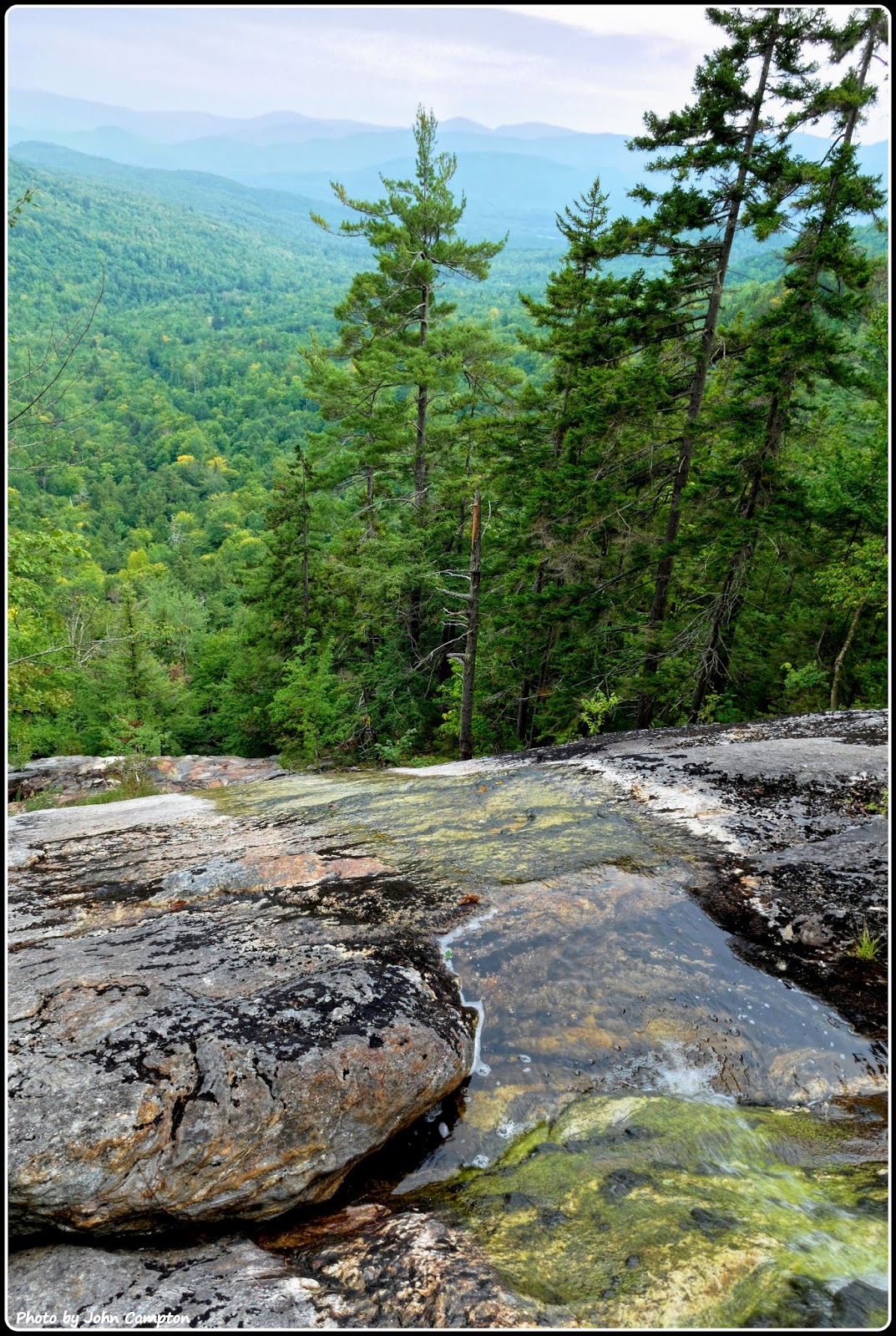
| The above photo was taken during the bushwhack portion of my trek. I was standing alongside the waterfall corridor on a small ledge located a few hundred feet below the point where the spur trail meets Dryad Fall. From this ledge is a sweeping vista looking ESE where several peaks in the Evans Notch area are visible, such as Caribou Mountain, Speckled Mountain, Mt. Hastings, the Royces, Howe Peak, etc. |
 |
| From the point where the spur trail meets Dryad Fall, there is a view shown in the above photo. Although similar, this view is less dramatic than the one shown in the previous photo taken from the small ledge located a few hundred feet below the trail/waterfall junction. |
 |
| Signage at the junction of the Dryad Fall spur trail and the Dryad Fall trail itself. |
 |
| And lastly, this is the season for fungi (mushrooms, and such), and this year there has been a banner crop! This composite-photo shows just a few of the many that were seen during this trek. |
TO SUM IT UP:
This
posting will be summed up via a hyperlink to a website which provides
additional information about Dryad Fall, as well as photos of this
waterfall when there is a significant flow of water. Click HERE
to access the link.
2 comments:
Nice! This looks like another fun and challenging hike on a great day. I had to laugh when you wrote about gaining 400 feet of elevation in only 0.2 miles. In my latest post (not yet published, but soon-to-be) I "brag" about gaining only a couple hundred feet over several miles!
The view from the ledge alongside the waterfall is fabulous. But I also enjoy the up-close fungi pics!
Another interesting post, John.
Thank you Rita for your comments. Glad you enjoyed the photo collage of fungi.
I just read and commented on your most recent blog posting that is viewable at this link: http://onedayinamerica.blogspot.com/2018/09/totally-above-treeline-horsethief-pack.html . . . what incredible views you experienced!
All the best,
John
Post a Comment