
Cape Horn is an unusual mountain with a rather
unusual name. No one apparently knows
for certain how this name came to be. One of the many theories is that the moniker is
derived from the mountain's resemblance to Cape Horn in South America. Regardless, the name has
been around for nearly 200 years. It
appeared on Philip Carrigain's famous map generated in the year 1816.
The
arcing ridge known as Cape Horn, lies within a public parcel of land known as
the Cape Horn State Forest (CHSF). A large portion
of the ridge and its eastern slope lies within the CHSF, as does the southern
half of its western slope. The highest
point (2,040 ft) is near the northern end and is located on
private property, just outside the CHSF boundary.
Cape Horn is Jurassic in age, dated at 182 million
years old. In geologic terms, it is classified as a ring dike which was formed
by an upwelling of molten magma in a conical-shaped fracture in the Earth's
crust. There's a very brief online video
which explains this process in simple terms (click HERE).
Also, there is an excellent scientific report
about Cape Horn that is available online (click HERE). This report contains many interesting photos and diagrams.
There are two points where the CHSF property
meets a public roadway. One is along
Lost Nation Road, and the other is along Page Hill Road. A few years ago in July 2010, I launched a
hike to Cape Horn from Lost Nation Road.
However, on my most recent trek in early November
2013, I began my hike from Page Hill Road at the Corridor 5 Snowmobile Trail. Both of the aforementioned treks were done
entirely on public land within the boundary of the CHSF property. And, both included a bushwhack component.
For the 2010 trek I began by following what is perhaps
an old logging road until it petered out, and then I bushwhacked the remaining
distance to the top of the ridgeline.
For my recent 2013 adventure, I followed the Corridor 5 Snowmobile Trail
for about a mile to the point where it crosses Dean Brook on a bridge. About a tenth of a mile after the trail
crossed the bridge, I began an eastward bushwhack through open woods to the
southern end of the Cape Horn ridgeline. Getting up onto the ridgeline involved a
moderately steep climb. But once there,
it was pretty laid-back with easily navigable ups and downs through a park-like
setting of open woodlands comprised of a mix of hardwoods and conifers.
With such a long introduction, perhaps it's
time to present a few pictures! I'll
begin with a map which shows key features such as the boundary of the CHSF,
some of the surrounding roadways, etc. (Click on this map to enlarge it.)
 |
| Map showing Cape Horn State Forest and nearby surroundings (CLICK TO ENLARGE) |
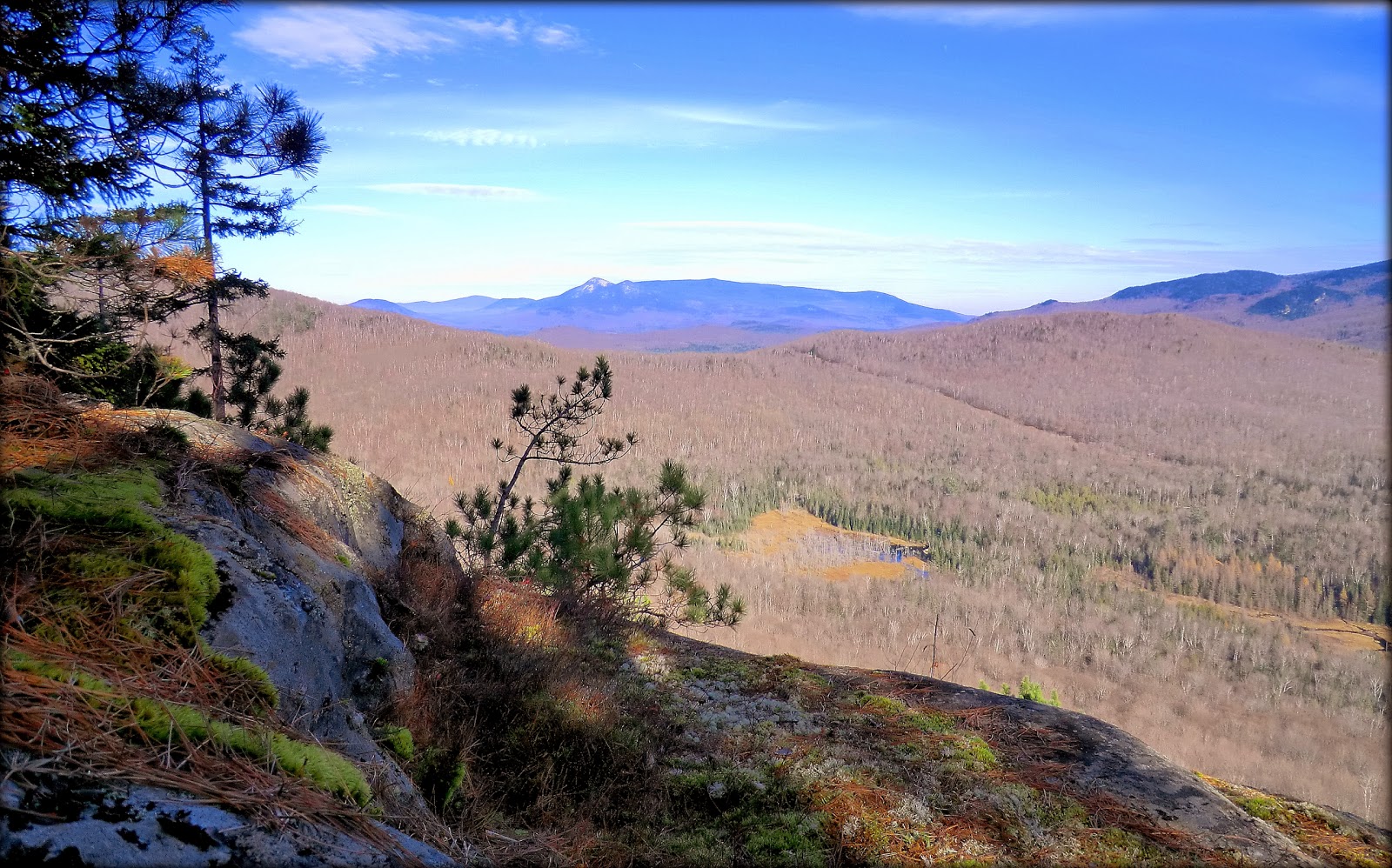
The next photo shows Cape Horn as viewed from
the snowmobile trail.
Earlier in this report, you might recall that
it was speculated that Cape Horn might have gotten its name because of its resemblance
to Cape Horn in South America. Shown
below is a photo that I grabbed from the Internet which shows the South
American version of Cape Horn. Perhaps
there is a certain similarity between these two places!?
 |
Cape Horn as viewed from the snowmobile
trail
|
 |
| Photo from Internet showing the Cape Horn located in South America |
Besides the view of Cape Horn, the snowmobile
trail also provides a nice view of mountains in the Pilot and Pliny ranges.
The next photo shows Dean Brook at the point
where the snowmobile trail crosses over it.
 |
| Mountains in Pilot and Pliny ranges, as viewed from snowmobile trail |
 |
Dean Brook at the point where the snowmobile
trail crosses over it
|
 |
Hutchins Mountain on horizon with portion of
Dean Brook drainage in foreground
|
 |
| A distant view of Percy Peaks from a ledge along Cape Horn's ridgeline |
 |
| Highly-zoomed image of Percy Peaks as seen from Cape Horn |
 |
| Photo taken July 2010 from a ledge near Cape Horn's North Peak |
 |
| Scene of contented cows grazing, as seen while en route to my Cape Horn hike |
7 comments:
John - Excellent report with a wealth of information. What a fascinating place! I would never have guessed that Cape Horn had such great views, interesting geology and diverse and rare flora. Especially like the view over the wetlands to the Pilot Range. I've driven by it a number of times and have not paid attention. Will have to go check it out sometime!
Steve
Steve, I’m very appreciative of your kind words about my report. Thank you!
Your assessment about Cape Horn being a “fascinating place” is accurate, as far as I’m concerned! My two forays to the ridgeline have been rewarding experiences, and I feel there is even more to explore along Cape Horn’s ridge. Also, I think there are other very worthwhile adventures to be had by exploring the bottom of the cliffs and talus fields at the base of the eastern slope, as well as the wetlands that lie further east of there.
Regarding the views from Cape Horn’s ridgeline, they are elusive and don’t really show up clearly on Google Earth. Sort of makes you wonder how many other places there are with views that are undetectable from satellite imagery! Yup! There’s a wealth of opportunity to spend many hours of pleasurable tramping in the woods while searching for ‘hidden treasures’. :-)
John
Most unusual, John! I suppose your New Hampshire Cape Horn does resemble the South American Cape Horn in that it seems to be a "stand-alone" mountain—and that's also unusual among the NH peaks and ranges typically in your reports.
I love the long views across open country on the way to this peak.
And finally, the cows and homestead picture is amazing (wonderful lighting). I think the lyrics of "Home, Sweet Home" could be changed for this scene to: "be it ever so crumbling, there's no place like home"!
Hi Rita,
You are so right with your assessment that Cape Horn is ‘most unusual’! I’m very eager to go back there and do some exploring along the bottom of its eastern slope. However, I might delay this until Springtime since the route I used will soon be a highway for snowmobiles. During the Wintertime, I respect the fact that this corridor is their domain. It’s disconcerting to both the snowmobiler and to the hiker to share the same passageway!
Glad you liked the ‘cows and homestead’ photo. The moment I came upon this scene, I simply had to pull over and take a snapshot!
John
John,
I have stumbled onto and used your posts off and on the past couple years to find waterfalls, cliff faces, etc. and they have proved most valuable. I appreciate what you do and am amazed at just how many places you've seen. (I get around pretty well myself and wonder just how many times I have passed you in the woods or driven by your parked vehicle. Oh the stories we could share, I'm sure!) Anyway, I felt compelled to thank you and to share at least this one story concerning Cape Horn. Five or six years ago, just out of high school, my friend Leif and I bushwhacked our way up Cape Horn from his house on the southeast side. We crossed a couple beaver bogs and scaled the ledgy hillside. We discovered the beautiful ledge you have the picture from, as well. Not too far from there, at the south end of the spine of the ridgeline there are a couple piles of boulders and outcroppings. Walking around them, we stumbled onto a few crawl spaces and then Leif found a larger chasm deep enough to lower himself down into (he is 6' 3"). He shimmied right down out of sight. After a few seconds he started yelling to me. I could hear the excitement in his voice. It was pitch black down there and he couldn't see anything (neither of us had a light of any kind). He was yelling something about a chest and buried treasure! I thought he was just trying to be funny at first, but his expletives showed his true excitement. Anyway, he couldn't see exactly what it was down there, only feeling a large metal box with clasps in the darkness. He crawled out of the horizontal cavern and lifted it up to me out of the big crack he had wedged himself down into. My blood was pumping as I wiped the dirt off the top of the heavy old metal box. I couldn't see any writing on it. Leif quickly lifted himself out of the hole, which I don't think he could have done so easily without the adrenaline. Before we opened it, we made a pact to split 50/50 whatever was inside. We undid the locking clasps and low and behold.....we had ourselves a rusty old vintage coleman stove.... How disappointing! I'll never forget the excitement of the anticipation and thoughts of golden deblooms, though. I pity the poor fool who lugged that 20-plus pound box up there. And why? I've had fun imagining D.B. Cooper-type figures camping out in that cave 50 years ago with that rusty Coleman stove. Needless to say, we didn't carry it out with us and it is probably still laying there next to the boulder pile.
Leif and I returned with headlamps a few days later to explore the caves, which turned out to be quite expansive, with several tunnels and cavern rooms, one which you could almost stand up in! A few months later, I brought my then-girlfriend, now-wife, Maylynda, up there to show her the caves. When we were standing on the ledge, a severe thunderstorm came soaring upon us in a matter of seconds. We ran to the caves and shimmied our way down in to wait out the storm. There we waited for two hours while the rain came down in sheets outside the crawl space. Coincidentally, I happened to have my Kindle Fire in my backpack to read when I sat down to take breaks on my other adventures. I had a few movies that I had downloaded into it. So we watched 127 Hours...the story about the guy in Utah who was trapped in a cave, when a boulder crushed his arm... Oh the irony!
This trip (on the ledge) was the first time that I told my girlfriend/wife that I loved her.
A memory that will be cherished by both my wife and I as long as we live.
Ethan, thank you so much for your kind words, also many thanks for taking time to share such thoroughly delightful stories about your experiences on Cape Horn. It’s easy to understand why some of those memories about your ramblings at this location will be forever cherished by you and your wife.
I’ll take a moment to share a brief story that sort of roughly relates to your comment about us never having met, despite both of us being out in the woods so frequently. A few years ago when bushwhacking to a favorite ledge in the Kilkenny region, I was shocked to find a Forest Ranger in full uniform eating his lunch. He was equally shocked to see me, and said that he didn’t think anyone knew about this spot. Anyway, we exchanged only a few more words, and then he left. So once again, I then had this spot all to myself. I’ve often wondered if the Forest Ranger tells the story about the stranger who knew about his “secret spot” and interrupted his lunch break.
All the best to you,
John
John, Thanks for the response.
I, too, have a favorite ledge in the (western) Kilkenny region that requires a bushwhack. Maybe it's the same one and maybe it's not so secret. It's one of the most impressive ledges I've stood upon. Just something about it made my heart race when no others do.
Post a Comment