
For the past few years, my friend Marty and I have talked
about hiking to the summit of Camel's Hump mountain in central Vermont. Well, 18-August-2012 was the day that we
finally made the 2-hour drive from Bethlehem, NH and climbed up to the top of
"hump"!
Camel's Hump (4,083 ft. elevation) is Vermont's
third-highest mountain. Because of its
distinctive profile, it's probably the state's most recognized mountain. And actually, Camel's Hump was chosen as a
prominent feature for the quarter-dollar coin issued under the U.S. Mint's 50
State Quarters program. A seven-person
panel ultimately decided on including Camel's Hump in the design, saying: "It's
wild and natural, like the Vermont countryside. It's unique and asymmetrical,
like the independent and quirky reputation Vermonters have."

Composite photo of real-life view of Camel's Hump, plus the backside of Vermont quarter-dollar coin
The following text is a brief compilation of some additional
information about Camel's Hump. It was
gathered from a variety of Internet resources.
The first European to see this mountain was probably Samuel de Champlain
during his expedition of 1609. The mountain
has had several names related to its distinctive shape. De Champlain named the mountain as "Le Lion
Couchant", which roughly translates as "The Resting Lion". On a 1798 map, the mountain is referred to as
"Camel's Rump". It was around 1830
when the name "Camel's Hump" came into general usage. Although Camel's Hump looks somewhat volcanic
from the east and west, it was the movement of glacial ice which created its
current form. On the summit, there are about 10
acres of fragile alpine tundra vegetation.
Okay, with that rather lengthy introduction, here are
some details about our hike, as well as a few snapshots that were taken along
the way.
Regarding our route, we did a loop (approximately 7.5
miles round-trip). We ascended using the
Monroe Trail, plus a short segment of the Long Trail. For our descent we used a combination of the
Long Trail, the Dean Trail and the Monroe Trail. Our route is highlighted in pink on the map
snippet that is shown below. If you look
closely, you'll see that some of the pink highlighting protrudes into the
Alpine Trail. We did a short side-trip along
a small portion of that trail in order to check out the crash site of a World
War II bomber (more about this later in the report).

Our route is highlighted in pink
Marty and I have hiked all of the NH 4K peaks, as well as
a 4K peak in Maine. By far, Camel's Hump
(via the Monroe Trail) was the easiest ascent of any 4K peak that either of us
have hiked to date. The trail's footway
has relatively few rocks and roots, as compared to many other trails that lead to
4K destinations. And, except for the
last 0.3 mile ascent of the summit cone, the incline is overall quite gradual. Shown below is a typical segment of the
Monroe Trail.

Typical segment of the Monroe Trail
Once we arrived at the top, it was as
"party-time"! This is a very
popular destination, and as a result, there were a lot of people! However, the summit area is large enough to accommodate
a large crowd, and there are plenty of nooks and crannies where you can find
your own personal space. Shown in the
next photo is just a small snippet of the folks congregated at the top of
Camel's Hump.

A small vignette of the many folks atop Camel's Hump on a
lovely day in late summer
Once we found a nice spot to enjoy our personal
experience on the summit of Camel's Hump, we then started looking around and were
thrilled by the multitude of magnificent views in all directions.
Shown below are a series of photos taken toward the four
major directions of the compass. Hopefully,
you can get some sense of the vistas by looking at each snapshot along with the
caption that appears beneath each of them.

A view looking northward toward Mt. Mansfield

A view looking southward along the ridgeline traversed by
the Long Trail

A view looking westward across Lake Champlain toward New
York's Adirondack Mountains

Zoomed view toward Burlington's airport
runway. (It must be a magnificent
sight to fly into Burlington on a clear day!)

A view looking eastward toward Mt. Hunger in the
Worcester Range of mountains

Yet another eastern view, but from a different
perspective

Just a random scene (looking downward from Camel's Hump summit)

Another random scene (looking upward toward summit of
Camel's Hump)
We could've spent more time on Camel's Hump, but it came
time when we knew we needed to begin our descent. As mentioned earlier in this report, we made
a short side trip on our way down. We
hiked for about 0.2 mile along the Alpine Trail in order to visit the crash site
of a B-24 Liberator bomber from the World War II era. The plane
went down in 1944 during a training mission. While most of the plane was salvaged
and removed, a wing section still remains (photo below).

A wing section from a WW II era Liberator bomber aircraft
that crashed in 1944
After visiting the crash site, we backtracked to the Long
Trail and proceeded southward toward the Dean Trail. Neither Marty nor I have ever hiked any
portion of the Long Trail prior to this.
Therefore, we have no idea if the short segment that we hiked is
representative of the Long Trail as a whole.
Regardless, we can say with certainty that the portion we hiked is
nothing remotely similar to the Monroe Trail!
This segment of the Long Trail was indeed "long", and it was
very arduous with many "ups & downs". In the White Mountains, we call these PUDs
(i.e. Pointless Ups & Downs). In
addition to the PUDs, there were many steep sections over rock that was
slippery, even when dry! Is this perhaps
the type of rock that is called schist??
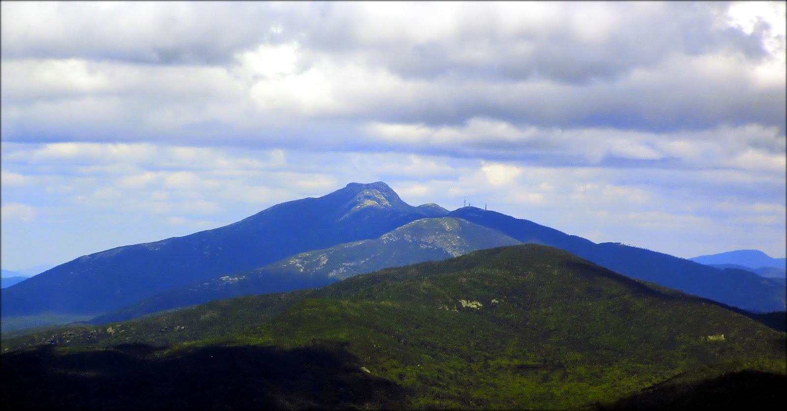
Despite our issues with the return leg of our journey
along the Long Trail, it was a still a fun adventure. Plus, the trail has one very redeeming feature! At a point about midway along the route, there is a
magnificent head-on view of south-face of Camel's Hump. The next two photos show this remarkable vista.

Head-on view of south-face of Camel's Hump

Zoomed snapshot of the same view as shown above
Just as we were beginning to think it would never happen,
we eventually met up with the Dean Trail which would lead us over to the Monroe
Trail and then back to the trailhead where we were parked. What a contrast there was between the Dean
Trail and the Long Trail! The footpath
was smooth, and the trail was relatively flat with only a slight downhill
grade. There was even a lovely meadow
of wildflowers at one point along the way (next photo).

Meadow of wildflowers along the Dean Trail
////////////////////////////////////////
ADDENDUM:
A few days after hiking to Camel's Hump, I returned to Vermont in order to hike to Mt. Hunger in the Worcester Range. One of the photos in this report shows a view of the Worcester Range as viewed from the top of Camel's Hump. If you're interested in reading the Blog report that was written about my trek to Mt. Hunger, then please click HERE.
26 comments:
Hi John,
Great telling of your hike, as always. Srini and I (and Kodi) hiked Camel's Hump for the first time on Christmas Eve last year. We hiked in from the other side -- Forest City Trail -- Long Trail -- Burrows Trail Loop. I concur with you on the Long Trail. That section, especially in winter, was really tricky, but beautiful.
Next Sunday, my nephew and I plan to hike Camel's Hump, so it was great to see your summary of an August hike. I hope we get great weather too as the views from the top are spectacular.
Ellen
Very nice John.
So I guess descending on the Monroe Trail would have avoided the long and grueling part of the hike?
Ellen, thank you for your comments!
Wow, a winter trek to Camel’s Hump must be spectacular, especially on one of those clear days when you can see forever and the wind-chill isn’t an issue!
Regarding that “tricky” section of the Long Trail, my friend Marty and I were both happy that we took the opportunity to experience it. Now that we have some familiarity with it, we know to factor in some extra time should we ever want to incorporate that trail into a loop for a future hike to “the hump”.
You have my best wishes for wonderful weather and a truly terrific trek to Camel’s Hump next Sunday with your nephew.
John
Hi Gary,
I really appreciate you taking time to post your comments!
Regarding your question, the Monroe Trail is a very mild and gentle trail. By using that trail for our ascent, it took us only 2-hours to hike to the summit from the trailhead parking lot. And so, you are correct in your assumption that we would have had a shorter and easier descent if we had simply retraced the same route that we had used for our ascent.
John
Vermont schist is a bugger, isn't it? I've northbounded over Camel's Hump on an end-to-end when it was wet, and southbounded over it in the dry (last week) with roughly equal amounts of pain and cursing. Given equal weather conditions, though, think the southbound descent is the more difficult. I found CH to be much more challenging than the LT as a whole.
Terrific comments, Vegematic!!
It’s reassuring to know that Marty and I are not alone in our evaluations of the Vermont schist, and the southbound descent from Camel’s Hump along the Long Trail. But all that aside, hiking in VT is a fabulous experience! I relish the new and interesting hiking opportunities that it presents to me.
Thanks for posting info about your VT treks!
John
Hi John,
I haven't done much hiking in Vermont, but your great pictures and descriptions make me feel like I'm missing out. But coming from MA, getting to the Whites is a long enough drive. Vermont would be a difficult trip for just a day hike. One of these days....
Hey, I wanted to thank you. I did the Wildcat Ridge Trail yesterday and took the Polecat down and it was a great hike. The only thing I did differently was I added the out-and-back to Wildcat A since I hadn't been there before. You were absolutely correct about the panoramic view of the Presidentials as you descend Polecat - absolutely breathtaking! Plus, the wildflowers growing on the ski trail were beautiful and there were thousands of butterflies. I also did what you suggested and parked at Wildcat and got the road walk to the Pinkham Notch V.C. and the trailhead out of the way first. As I got back to my car, I thought how nice it was to not have another mile walk down the road to my car at the end of a hike.
So anyway, thank you for your input...your experience definitely helped me make mine be the best it could be.
Hey Chris,
Your follow-up is so appreciated! It’s truly fantastic and very rewarding to read that you took my suggestion and that you enjoyed hiking down the Polecat Ski Trail. That is one of my absolute favorite hikes! I enjoy hiking the peaks in the Presidential Range as much as anyone. However, I sometimes think that it might be slightly better to be LOOKING at the Presidentials, rather than actually hiking them. Hard to explain, but perhaps you get the gist of what I’m struggling to say.
Regarding Vermont, for certain there is some really nice hiking over there! However, I can certainly appreciate that living in MA would present some complexities and added mileage! And even though I live in northern NH, even for me it’s a long drive when I visit locations beyond the region of VT known as the NEK (North East Kingdom).
Oh! Before I forget . . . congratulations on including Wildcat A in your hike. That was quite an accomplishment! The Wildcat Ridge has a lot of undulations known as PUDs (Pointless Ups & Downs). You successfully negotiated the PUDs twice during your “out-and-back”! It must have been a very welcome sight to have your car ready and waiting for you at the end of your descent on the Polecat! :-)
John
John,
Amazing picture of the zoomed in profile of the Camel's Hump, spectacular!! Alton and I were in Burlington VT for the weekend and hiked Mansfield on our way back on Sunday and as we were driving we could see Camel's Hump and we are looking forward to hiking it in the future. Your report and pics as always are awesome and a really good source for everyone.
-Chris
Hey Chris . . . mega-thanks for your very generous comments!
You and Alton would definitely enjoy hiking to Camel’s Hump!
And regarding Mansfield, congrats on doing that one! I have yet to hike it, but am looking forward to doing so. Given the right weather conditions, and the right time of day, the views from there must be awesome!
John
Ok, now you're teasing me with all those great pictures of Vermont! LOL. You and Marty had an absolutely stunning day up there! Just beautiful and the profile pictures really do help explain the name of Camel's Hump. We have plans for Vermont next summer, which will include Camel's Hump. I have heard many tales of the slippery rock of Vermont and how it is different from the rock in NH. That's another experience I'll file away under "things to be careful around in VT".
As I was reading your post and looking at the pictures I was thinking "Wow, I enjoy reading about all of John's hikes but this one is really special!" And I see that you felt the same! The perfect weather and the 360 degree views—just amazing! I really like the view looking across Lake Champlain to the Adirondacks.
In the "learn something new" category, I didn't know that Camel's Hump was featured on the back of the Vermont quarter (of course I didn't know about Camel's Hump at all until this evening).
And another crashed airplane? I wonder how many plane crashes occurred in the mountains of New England?
Yet another great post!
Jonh,
On your way back, did you stop at Ben & Jerry? :)
Hi Summerset,
Well, Vermont is quite a tease! For years I’ve not taken the “plunge” to cross over the border and do some hiking there. But like so many things, once you’ve experienced it, then there’s no turning back!
It great to read from your comments (and from your recent Blog posting, link below) that you and your family are planning some adventures in VT next summer. I think you’ll find it different, as well as very rewarding!
http://nh48.wordpress.com/2012/08/22/classic-washington-via-tuckermans-ravine-8-20-12/
John
It’s so terrific to read that you especially enjoyed reading this particular Blog posting. And you’re correct in your assessment that this hike was pretty special. Marty and I had talked about doing this hike for a couple of years. However, this exceeded our expectations in terms of the views, the ease of driving to the trailhead from NH, and the ease of ascending Camel’s Hump. Plus, we were simply “blown away” by having such terrific weather conditions! What a stroke of luck that was!!
Regarding the back of the Vermont quarter dollar coin, having Camel’s Hump there is pretty neat. But likewise, so is the obverse of your Utah quarter dollar coin with the two locomotives moving toward the golden spike that joined the Central Pacific and Union Pacific railroads.
Regarding the number of plane crashes in the mountains of New England, there have been several. But, given the rapidly changing weather of New England and the rugged terrain, I suppose it’s not too surprising.
Thanks Rita for posting our comments. As always, I’m very appreciative!
John
Ah Yvon! That is a terrific question! I wish the answer was yes, but sadly, the answer is no!
After spending a delightful (but long) day exploring Camel’s Hump, we were eager to go home and enjoy some liquid refreshments, and dinner!
I had some ice cream at home for dessert. Does that count?? :-)
John
Excellent report and superb photos, John! The Hump is the best of Vermont. Mike D. and I did that same route many years ago, and we remember that wicked descent on the south side. We spent several hours on the summit and ran into some guys dressed in camo and wearing big sheath knives who were looking for the plane wreck.
Steve
Hi Steve,
Your comment deserves a double WOW! First, I’m surprised (and also delighted) to read that you and Mike not only hiked the same route as Marty and I, but also that you were left with the same impression as we were about the “wicked descent” on the south side! And the second “Wow” pertains to your comment about the guys dressed in camo and wearing big sheath knives as part of a quest to find the plane wreck. You have to wonder what that was all about?? :-)
John
Nope! That does not count :)
After we have had a ride on a real camel hump in India last november, by reading your TR, we will hike on the mountain very soon and maybe this weekend. We did not do from this side, so we probably do it same as you John.
Yvon
Yvon, best wishes to you and Annie for a terrific “ride” on the Camel’s Hump when you visit Vermont! I’ll look forward to reading your report.
John
I'm still catching up on my reading after being off the grid so much lately. Glad I made it back to this one! This was the only 4k that we hiked in VT, but as you always do, you found a way to put it in a very different and interesting light. I wasn't even aware of the plane crash site. The photos are stunning. Clearly it was a perfect day to be at the top 'o the Hump!
Whew! I can relate to what you’re saying about catching up after being off the grid! With so many fine folks generating so many fine reports, it’s a challenge to keep up! Even being “off the grid” for a day can create quite a backlog! :-)
Regardless, your statement is absolutely correct, i.e. "Clearly it was a perfect day to be at the top ‘o the Hump!”
Thanks for your comments . . . much appreciated, as always!
John
Hi John,
I just found your site today. We went to Vermont, stayed in Burlington for a week last July and are going to be coming back this July. We hiked Ethan Allen (Forest City/Long Trail) and 3 days later felt recovered enough to do Camels Hump on teh Burrows Trail. We found teh rocks to be very steep in sections and always slippery as well. Thanks for giving me a name to curse at the rocks, schist! Great hike, though challenging and we can't wait to get back up on the trails this year! Beautiful pictures!
Lauren . . . glad you found my Blog, and thanks for taking time to post your comments.
And yes, there is a certain level of satisfaction with being able to curse those slippery rocks with words like “oh schist”! :-)
Hope you have a great week in Burlington in July. As you’ve obviously discovered, Burlington is a terrific town with lots of great outdoor things to do in the city itself, plus it makes a great home base for day trips to places like Camel’s Hump.
John
Great write-up and photos of my favorite Vermont mountain. Over my 40 plus years of climbing this mountain the hikers have gotten more numerous but Camel's Hump remains one of the few high/spectacular view mountains with no access other than your two feet. On a clear day with binoculars you can actually see the skyscrapers in Montreal. The remains of the crashed plane are tougher to see from the top now thanks to new growth trees but I have made a small contribution to making those remains even less visible- Years ago I "liberated" a small part to take home thanks to a handy hacksaw. (What, you mean not everyone carries a hacksaw in their backpack?)
Chip in Cabot, VT
Chip, first of all, my apologies for such a tardy posting of your comments. For whatever reason, the blogger website just now notified me that you had submitted a reply to my Blog.
Regardless, thanks for your comments. I found it especially interesting that on a clear day one can see the skyscrapers in Montreal with the aid of binoculars!
John
Post a Comment