
Back in the day before the automobile was commonplace, I
assume that the folks in Bethlehem would merely step out the door and hike to the
top of Mt. Agassiz. Regardless of
whether that was indeed the case, it is something that I occasionally do. It's about a 5 mile round-trip jaunt from my
doorstep to the top of the mountain. As will be explained later, there is a more
direct route available to the public which does not involve leaving from my
doorstep. :-)
And so, the journey from my doorstep begins by walking
into the woods at the edge of my property.
(As always, click on any of the photos for enhanced viewing.)
(As always, click on any of the photos for enhanced viewing.)

Where my journey begins
A short walk on a pathway through the woods brings me to
a rail corridor that once ran through the village of Bethlehem up until the
early 1900s.

Old rail corridor
In certain places along the rail corridor, you can still
spot some of the old wooden ties.

An old railroad tie
Most of the old rail corridor is wooded on either side,
but there is one spot where you can gaze across an opening and see mountains in
the Dalton Range.

Dalton Range viewed from old rail corridor
The old rail corridor eventually peters out, and then I
head toward Main Street (US 302) where I emerge nearly opposite an eatery
called Rosa Flamingos. Once upon a time,
at a spot just a few hundred feet from Rosa's, was the trailhead for Turner's
Path which led to the top of Mt. Agassiz.
And actually, at one time this was one of four (4) trails from various
locations in Bethlehem that would lead you to the top of this mountain! In addition to Turner's Path, there was the
Maplewood Path, the Strawberry Hill Path, and the Agassiz Carriage Road.

Rosa Flamingos (Turner's Path to Mt. Agassiz once left
from a spot nearby)
My walk down Main Street takes me past a picturesque
church which has been decommissioned and no longer in use. It's for sale! Anyone in the market for a church?

Church for sale
And as I continue down Main Street, I walk past a variety
of businesses, such as those shown in the next two snapshots.

Antique store

My amble down Main Street also takes me past a building
that has been an eyesore for years.
Finally, the legal and financial obstacles have been overcome, and it
will be demolished over the next several weeks.
The current plans are for the property to become the site of a new
Public Library for the village of Bethlehem.
This building was built in 1876 as a hotel which was
originally called the Avenue House, and later was named the Gramercy. However, when it was last operational as a
hotel it was known as the Maplehurst.
Before its demise it operated for a number of years as the Chase Golf
and Tennis Camp. When John Kennedy, Jr
was 15 years old, he stayed at this camp for a month in the mid 1970s.
Here is a composite photo of this old building as it is readied for
demolition. (This will eventually be the site of the new Bethlehem Public Library.)

Maplehurst Hotel as it appears in June 2012
And shown below is how this building
appeared in its heyday.

Maplehurst Hotel in its heyday
Eventually, I leave Main Street and head up Agassiz
Street (NH 142) which will take me to the entrance to the former Agassiz
Carriage Road that leads to the top of Mt. Agassiz.
As I walk along Agassiz Street, I can catch glimpses of
my destination. In the next photo, Mt.
Agassiz (with communication tower barely visible) can be seen on the horizon
just to left of the house seen in the foreground.

Mt. Agassiz (with tower on top) on the horizon
The point at which I leave Agassiz Street (NH 142) is
also the where the public can begin a hike to Mt. Agassiz by parking at a wide
spot along the shoulder of the east side of road, exactly one-mile south of the
junction of NH 142 and US 302 in the center of Bethlehem village. The next
photo shows the "trailhead" parking on the shoulder of the road.

"Trailhead" parking for Mt. Agassiz
As you begin your trek, you might think you're at the
wrong spot! On the first 100 ft or so of
the road to Mt. Agassiz there are some rusting abandoned cars, plus a couple
of rundown buildings. However, just keep
walking and very soon you'll see the sign shown in the next photo. (If you
don't soon see this sign, then you're on the wrong road!)

Sign near beginning of road to Mt. Agassiz
Most of the road leading to the top of Mt. Agassiz looks
similar to what is shown in the next photo.

Typical section of roadway that you walk to top of Mt.
Agassiz
Rather than hike the road, there is a path through the
woods for the lower portion of the trek.
However, it's too complicated to explain as to how to access it, and
besides you eventually need to emerge back onto the road for the final push to the
top.

Path through the woods at lower end of route to Mt.
Agassiz
On the way up to the mountain, there is a short side-path
that leads to a spot where you can sort of get a preview of the vista available
from the top of Mt. Agassiz.

View from short side path along route to top of Mt. Agassiz
When you get to the top of the mountain, the owner has
kindly placed a sign which provides a brief history of Mt. Agassiz.

Sign providing a brief history of Mt. Agassiz
Besides the owner's generosity of allowing access to his
property, plus providing an informational sign, he also maintains a gorgeous
viewing area for hikers to enjoy, as seen in the next photo.

Viewing area at top of Mt. Agassiz
From this viewing area are several vistas including
mountains in the Franconia Range and Twin Range. A sampling of these views are seen in the
next two (2) photos.


While at the viewing area, I took a zoomed photo of the rocky summit of Mt. Lafayette (5,260 ft) which I had just visited earlier in the week when hiking the Franconia Ridge. (Click HERE for a report of that hiking adventure.)

Directly behind the viewing area sits the owners house, as shown in the next photo.


View toward Franconia Range

View toward Twin Range
While at the viewing area, I took a zoomed photo of the rocky summit of Mt. Lafayette (5,260 ft) which I had just visited earlier in the week when hiking the Franconia Ridge. (Click HERE for a report of that hiking adventure.)

Zoomed photo of Mt. Lafayette from Mt. Agassiz
Directly behind the viewing area sits the owners house, as shown in the next photo.
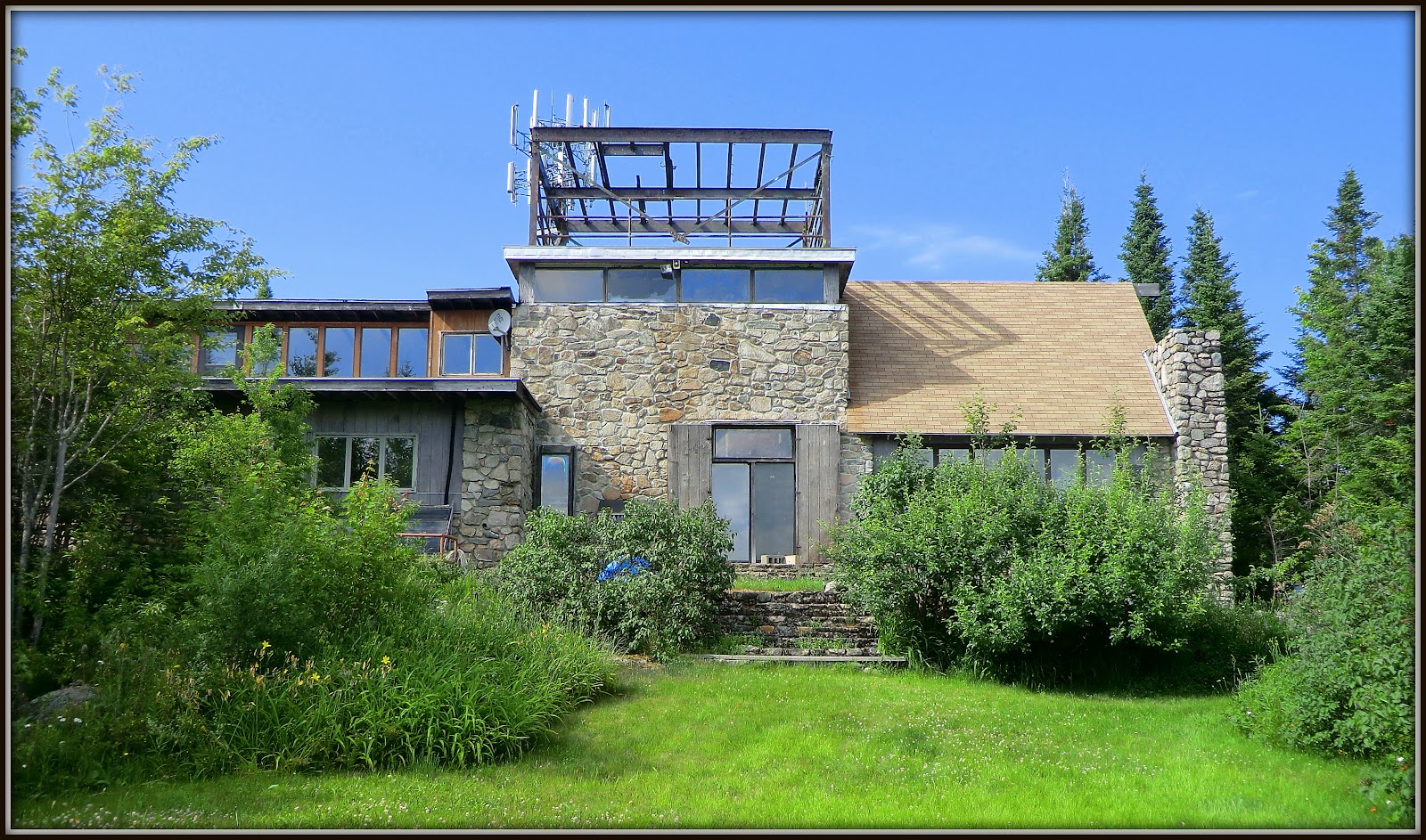
Owner's house atop Mt. Agassiz
I didn't linger for very long at the viewing area. The biting insects were out in force! And so, I descended the mountain and returned
home via the same route as was taken for the outbound leg of my journey.
To sum it up,
it's terrific to be able to launch this trek from the convenience of my
doorstep. As indicated in the title of
my report, perhaps this is the old-fashioned way of hiking to Mt. Agassiz, back
in the days before automobiles were commonplace. This is an enjoyable hike, and it also has
enough distance and elevation gain to keep you in shape for ramblings farther
from home.
25 comments:
Wow! What an amazing set of views! I can see that this is just one of the benefits of living in Bethlehem. How great to have such an option literally out your back door. Thanks for sharing a lovely day John.
Thanks Mark!
Although this “out-the-back-door” hike is particularly nice, most likely you also enjoy some nice locations which are nearby to where you live in RI. It seems that nearly everyone who lives in New England has heavenly bits of natural scenery that are easily reached on foot, or by a short car ride.
John
Nice, John! I haven't walked that old railroad bed in years. Back in my "youth" (about 25 years ago), the old ties were very visible, and you could follow the bed from Maplewood Hill road all the way to today's lower ball field (which was part of the golf course). From there, we could take the old road to behind the town pool, or another path north towards lower Maple Street and Wing Road. Glad to see parts of it are still clear!
Oh my! Chris, how I envy you growing up in such a magnificent place! Being a relative newcomer to Bethlehem, I often feel like I’m coming in at the middle of a movie, or at chapter 5 of a 10+ chapter book!
That is amazing that you could once follow the old rail bed from Maplewood Hill Road all the way to the lower ball field. Love hearing first-hand knowledge about this area!
Thanks so much for posting your comments!
John
Thanks John. We stay up in Whitefield on occasion and are always looking for hikes to do on Sunday mornings before we head back to CT.
Ann
Fantastic! It’s always so gratifying to learn that information presented in my Blog is beneficial to someone.
Thank you for taking time to post your comments!
John
This is a fascinating post, John. First, I love the view from your yard. Second, it was nice to see the views along Main Street in your home town. A church for sale in the town of Bethlehem? Sounds like it could be an interesting Bed and Breakfast Inn!
Third, the greenery of the forest and the vistas from the top of Mt. Agassiz are amazing!
Thanks for providing a most pleasant vicarious "stroll" through your town and its trails!
Rita
Hi Rita,
It’s wonderful to read that you enjoyed the vicarious stroll through Bethlehem, as well as the view from our side yard. And regarding your comment about a Bed & Breakfast opportunity for the old church that’s for sale, my wife and I have had the same thought. Either that or a conversion to a set of small condo suites.
Thanks as always for taking time to post a response.
John
I did this last year after seeing it no Rocket 21's website. Unfortunately it was cloudy the day I went, so it is neat to see what it looks like!
Love the blog, you've posted some nice obscure hikes that I have added to my list of hikes to do!! Thanks for your hard work of posting!!!!
Anonymous,
Thank you for your very kind comments!
It does take a bit of time and effort to post narrative and photos about hiking adventures. However, I enjoy doing it, and it’s made even more rewarding by folks like you who take a moment to post a comment and provide feedback as to whether the information is useful.
John
The roadbed starts at the Junction near the Ammonusuc River Before it passes the Maplewood Hotel station ( Standing whin I last saw it 15 years ago.) and continues to where you picked it up, and crosses Maple Street and beyond and terminates at the Bethlehem Railroad station. (Stil standing and in good repair as a private home). I can provide pictures of Bethlehem Rail station in it's heyday and recent on request. Phil Gilbert as windjammer73@gmail.com
Thanks Phil for reading my blog and posting your comments. Very much appreciated!
I have lived in Bethlehem for the past 10 years and am familiar with the corridor of the old railroad and with the landmarks that you mentioned. I’m within a 15 minute walk of the old Maplewood Station and visit it often when out and about. I have taken photos in all seasons of the year of the Maplewood Station in its current condition, and I have a couple of old prints showing the station in its heyday.
Thank you for your kind offer to provide me with pictures of Maplewood Station from your private collection. I’ll be contacting you at the e-mail address that you provided.
John
I grew up in Bethlehem in the 40's and 50's. I spent a lot of time exploring Mt. Agassiz which was uninhabited at the time. There is a steep section of boulders in the direction of Mt. Cleveland. I heard the legend of a cave and searched the whole area and concluded it was a myth. If you head off Agassiz in the direction of Maplewood you will come upon a path that leads to a gazebo and below it there is a camp which has the r temnants of benches and some shacks. Maybe a sugar shack or a meeting place. Below Agassiz towards Cleveland there are the remnants of a community probably used by hay fever sufferers. I remember some small cabins still stocked with numerous paper back books. At one time Gordon Miller tried to make the mountain into a tourist attraction building a base house and replacing the house on the summit. He hauled tourists up the road with a tractor called the magic mountain express. It failed. There is a neat area about 3/4 of the way up the road where there is a large flat granite plate covered with lichen. From there you could see a trail which contained a water pipe that pumped water to a huge tank. That's how they got water to the top. I often hiked to the top and skid down the road. I invite questions as I still remember the early days of Bethlehem.
Thank you so much for sharing your past explorations of Mt. Agassiz.
Of the many interesting things you described, the only one that I’ve come across was the trail relating to the water pipe corridor. Nowadays, exploration of the area surrounding Mt. Agassiz is nearly impossible since so much of it is private land.
You mentioned that you are open to questions about the Bethlehem area. Were you ever at a place in Bethlehem called Crufts Ledge? I have searched for it on several occasions, but never found it. I know that it was located on the hillside on the south side of Rt. 302 in the vicinity of the Maplewood Hotel and Casino. Unfortunately, where I think it might have been is now on private land with a house sitting on it!
John
No, I never heard of Crufts Ledge. The terrain south of the Maplewood Hotel drops into a deep valley and terminates at Gale River.(I may have the name wrong). There are many foot paths there as guests during the 20's loved to take nature walks. Did you know that up to the 50's the town contained 30 hotels. Many have since burned. These were not accidents. As the tourist industry collapsed, the owners didn't want to pay taxes. At least they burned them during the winter. If you ever get back there, check out the old hydro electric dam in Bethlehem Hollow. Also if you go down maple st. and follow the old railroad track bed towards Maplewood you will come to the remnants of another dam. At one time this area was a huge lake.
Thank you for your reply to my question.
I live in Bethlehem within a 5 minute walk of the Maplewood Golf Course. And so, I’m familiar with the unfortunate loss of the grand hotels that once graced this wonderful town. Also, I’ve explored many of the places you mentioned, such as the hydroelectric dam in Bethlehem Hollow, as well as the remnants of the other dam you mentioned. Bethlehem is a great place to live, as I think you would agree!
Thanks again for reading my blog and posting your comments!
John
I really enjoyed your blog, esp the pictures. They brought back many memories. I hope you will continue adding pictures. My name is Norm Beck. I grew up on congress st.. third house on the left counting the one that used to be on the corner. Interestingly, Phil Gilbert was a boyhood friend. I will check your blog from time to time looking for updates. Thanks.
I am so thankful I found your blog. I just hiked it and the views are insane. So quiet and nobody around! Have you ever seen any evidence of the ski area?
Peggy
Peggy, thanks for your comments!
Regarding your question, about a decade or so ago, it was possible to stand in the old ski area and get a view overlooking downtown Bethlehem. However, the last time I visited that area, it was filled with tall saplings that blocked the view.
John
Thanks John. My sister peggy told us about it via your blog
Went up today. Weather was picture perfect. Sunny. Warm nice breeze. With signs of lingering foliage. Simply gorgeous.
So glad you enjoyed the Mt. Agassiz hike. It’s a nice one!
John
Does anyone have any information on the house with all the glass art and rocks at the base of the mountain?
Hi “Unknown” . . . I have no information regarding the house with the rocks and glass art that is located at the base of the mountain. However, the occupant of the house seemed friendly on the few occasions that I have passed by him on my way up Mt. Agassiz. So, maybe you could strike up a conversation the next time you do this hike?
John
Does anyone have contact info on the owner?
I do not have contact info for Stan, the owner, but he's a friend of my dad's and I've met him a few times. I actually haven't had any contact with him since I started hiking profusely in the Whites, which is too bad, but he was always quite friendly and I'm sure he'd be happy to tell you all about the rocks there. One of these days I should actually hike up his mountain and say hi. He's owned it for as long as I've known him (40 years) and probably longer than that. This weekend I actually drove by the base for the first time - didn't hike because the weather was lousy - but I was happy to find your blog when looking for more info on Stan's mountain.
Post a Comment