Pages

About Me

My photo
Bethlehem, New Hampshire, United States
E-mail contact: randonneur8@yahoo.com | Facebook: facebook.com/1HappyHikerNH

Text Above Search Box

SEARCH MY BLOG USING TEXT BOX SEEN BELOW:

29 November 2012

Local Village Hikes: Franconia and Littleton, NH


Since I had some things to do in Littleton on 29-November, there was no time for doing a big hike.   However, there was time for a couple of small local hikes.

PART 1: Franconia, NH

Rather than take the direct route from Bethlehem to Littleton, I took a side trip to Franconia along the way.  Here, I stopped at Coffin Pond which is a lovely piece of public land.  Shown below are two snapshots taken of mountains in the Franconia Range as viewed from the shoreline of frozen Coffin Pond.


Before leaving Franconia, I made one more stop at a spot along the Gale River where I took the snapshots shown below.


PART 2: Littleton, NH:

After finishing up my business in Littleton, I walked some of the pathways in the Pine Hill Trail system which is most easily accessed from Remich Park, located just a few blocks from downtown Littleton at the junction of Oak Hill Avenue and Pine Hill Road.

Shown below is a map of the trail system.  The route that I followed is highlighted in yellow.

This trail system is very well maintained by Bill Nichols and his crew.  Also, the trails are very well signed.  Shown below are just a few of the many trail signs.

Oh!  And when there isn't a trail, there is a sign to tell you this! (The sign in the next photo is suspended by a cable stretched across the "Not A Trail" corridor.)

And regarding blazing, recycling and quaintness are intermixed by using metal pull-top can lids to mark the trails (next photo).

I did a loop hike which involved following signs to Palmer Brook, and a Ski Trail to Elm Street (next photo).

Palmer Brook is small, but picturesque (see photo below).

Another spot along my route was Teapot Rock, the site of an early 1900 logging camp (see photo below).

The trail system also includes tall pines, and typical New England rock walls (next photo).

To sum it up, although my two hikes for the day were small, they were very enjoyable.   I'm grateful to have options such as these for those days when the opportunity for a longer hike is unavailable.

/////////////////////////////////////////////////////////


ADDENDUM (added 03-Dec-2012):

This additional information and photos was added in response to a question received from a reader named "Hiking Lady" (see Comments to this Blog report).  The question concerned the location of the old ski slopes on Eustis Hill (Littleton, NH) in relation to the Pine Hill Trail System.

On the map shown below, it can be seen that the old Eustis Hill Ski area is in the south part of town, and the Pine Hills Trail System is on the north side.  However, Littleton isn’t that big.  It’s very easy to get from one place to the other.  Parking for the old ski slope is available on the west side of Mt. Eustis Road (see red "P" on map below). 
Map showing location of old Eustis Hill Ski area in relation to location of Pine Hill Trails

Below is a photo that I took from the Eustis Hill Ski area about a week before doing my trek on the Pine Hill Trails.  The vista from the top of the old slopes includes a portion of downtown Littleton along with several mountain ranges on the northeast horizon.
 Photo taken from top of old Eustis Hill Ski area

Another fine spot for a short hike while in Littleton is Kilburn Crags.  The current (as well as older editions) of AMC's White Mountain Guide contains a trail description for this hike.  The trek is only 1.8 miles (round-trip).  Views from the Crags include downtown Littleton, plus high peaks in the Presidential, Franconia-Twin, and Pilot mountain ranges.  The next photo shows a portion of this vista as seen a few years ago on a day in early April.
 A portion of the vista available from Kilburn Crags (just outside downtown Littleton, NH)

28 November 2012

A Hiker's Journey to Humphrey's Ledge


In the North Conway area there are three lumps on the landscape which are aligned in a row.   They are named White Horse Ledge, Cathedral Ledge, and Humphrey's Ledge.  Because of their sheer, bare-rock cliffs,  all three are destinations for rock climbers.  But hikers can also enjoy visiting two of those locations (White Horse Ledge and Cathedral Ledge) via a maintained trail system.   However, since there are no longer any maintained hiking trails leading to Humphrey's Ledge, nowadays it is mostly visited by rock climbers.  Therefore, in the title of my report, I wanted to make it clear that my journey was a hike, not a rock climb!

To set the scene, the first image in this report is a Google Earth shot of the area.  In addition to other identifying labels, I've also inserted a label which shows the destination for this particular hike.  As you'll see, I had a rather modest, low-key goal of merely visiting one small knob within the Humphrey's Ledge complex.
 Google Earth image with key features labeled

You'll recall that I stated above that there are no longer any hiking trails on Humphrey's Ledge.  This was not always true!  I don't know precisely how long it's been, but I think at least a half-century has passed since there were actively maintained trails at this location.  The composite photo below shows a USGS quadrangle map from 1942, as well as a modern day map.  On the old map, I've highlighted the two old trails that once led to Humphrey's Ledge (Humphrey's Ledge Trail, and Cow Brook Trail).   Highlighted on the modern day map is the approximate bushwhack route that I followed for this journey.  And on both maps, I've placed a red "X" to show the location of my destination.
Composite image showing 1942 USGS quad map, plus a modern-day map of the area

Further concerning the route that I took, it was easy to stay on public land since the boundary between public and private is well marked with red blazes (as shown in the next photo).  This image also serves to show the open hardwoods that I enjoyed for the entire length of my trek.
 Boundary blazing in an open hardwood forest

Referring back the old map that I posted above, perhaps some readers might be curious as to why I didn't try to reach my destination by following the corridor of the old trails.  Please allow me to interject a brief background story here!

About 3 years ago, I embarked on a mission trying to locate the Cow Brook Trail from its southern terminus in the vicinity of the Moat Mountain Trail.  I wanted to try following it northward to the old Humphrey's Ledge Trail, and then follow that trail to a point on Humphrey's Ledge.  I was never certain if I was ever on the Cow Brook Trail.  However, I'm nearly 100% certain that I located and followed the old Humphrey's Ledge Trail for awhile.  However, it became tedious trying to stay on this corridor, not only because it was faint, but also because of multiple patches of downed trees.   Since I was running out of daylight, I eventually aborted my mission and headed back down to the Moat Mountain Trail via a route similar to what was used on the journey that is the subject of this report.

And so, although there might be better routes to Humphrey's Ledge, my bushwhack pathway was chosen because of already being familiar with the terrain and the woods in this area.  Also, from my experience of 3 years ago, I knew that even if the old trails could be located, it was much quicker and easier to simply bushwhack through the open hardwoods!

Okay, that's enough (probably more than enough) background information.  So what about my hike?!  To begin with, it was a very easy bushwhack.  I arrived at my destination on the Humphrey's Ledge complex just 55 minutes from the time that I departed from the Moat Mountain trailhead.  The only real surprise along the way was finding some old cairns leading out to the knob where I was headed.  None of the old maps I've seen show a trail going to this particular spot.  Maybe it was a spur trail off the main trail, and just simply was never included on any of the maps??

Shown below is one of the old cairns encountered along the way as I approached my destination.
 One of several old cairns seen as I approached my destination

As to what I could see once I was atop the ledges, the first view I came to was looking at one of the many massive cliffs on Humphrey's Ledge.  Although I'm uncertain, I think the cliff in the next photo is the one that is most frequently used by rock climbers.
 One of the many massive cliffs on Humphrey's Ledge

Directly east from the cliff shown in the previous photo was a view of Kearsarge North.
 View of Kearsarge North from Humphrey's Ledge

After enjoying the views shown above, I moved further along toward my final destination at the end of a rocky knob on Humphrey's Ledge.  From this knob, I experienced several views, one of which is described in very early editions of AMC's White Mountain Guide as a "charming view of the Saco Intervales".  The next photo is what I think is being described in those old guidebooks.
Described in old WMGs as "charming view of the Saco Intervales" (view from Humphrey's Ledge)

From this knob on Humphrey's Ledge, I also had a view of the Moat Mountain Range, as seen in the next photo.
 View of the Moat Mountain Range, as seen from Humphrey's Ledge

Also while I was there, I zoomed in on the profile of Cathedral Ledge and White Horse Ledge standing side-by-side.
Profile of Cathedral Ledge and White Horse Ledge, as viewed from Humphrey's Ledge

And so that was it.  I'd met my modest goal.  I saw what I'd come to see, and felt no obligation to go onward to the highest point of this ledge complex, or to do further explorations of the area on this particular trip.

However, once I returned to the trailhead and was headed down the road for home, I did surrender to a nagging curiosity about the rock climbers trail.  I pulled to the side of the road and did a short jaunt up the trail to a point where I suppose the climber's launch their vertical assault on the massive cliffs.  By this time it was dusk, and there was a picturesque "through the trees " silhouette of Cathedral Ledge, White Horse Ledge and the Moat Mountain Range (next photo).
Silhouette of  Cathedral Ledge, White Horse Ledge and Moat Mountains (from rock climber trail)

Shown below is a snapshot looking up at the cliffs from the rock climber trail at the Humphrey Ledge location.
 Looking up at the cliffs on Humphrey's Ledge from the rock climber trail

As is nearly always the case on my hikes, I saw no large animals of the forest such as moose, bear, etc.  However, I did see an alpaca which, technically speaking, was part of my hiking adventure!  This animal was spotted at a farm on West Side Road while en route to the trailhead.
 Alpaca as seen at a farm on West Side Road while en route to the trailhead

To sum it up, this was a short, but pleasant bushwhack to a knob on Humphrey's Ledge.  It was my first visit to this location, and I always like doing something new!  Although the landmarks that I viewed were familiar, I enjoyed having a perspective which was slightly different from that of other locations I've visited.  And last but not least, it was great to finally reach a destination that I was unsuccessful in reaching on a previous trek due to time constraints. 

20 November 2012

A Bushwhack to Bartlett Haystack (or Mt. Silver Spring, if you prefer)


According to the AMC's White Mountain Guide (WMG), Bartlett Haystack previously had been called Mt. Silver Spring.  As the 29th edition of the WMG puts it on page 221, this was "in the days when hazy elegance was preferred to plain and effective description."  According to the book by Robert and Mary Julyan entitled "Place Names of the White Mountains", this peak also has been called Revelation, for reasons unknown.

Bartlett Haystack sure seems like an appropriate name to me!  Not only is it located not far from Bartlett, NH, but it certainly resembles a haystack!  Take a look at the snapshot shown below and see what you think.  (This photo was taken from a pull-off area along Bear Notch Road on my way to the launch point for my bushwhack.)
Bartlett Haystack as seen from Bear Notch Road

The 1940 edition of the WMG also refers to this mountain as Mt. Silver Spring, rather than Bartlett Haystack.  Shown below is a map from the 1940 guidebook.  The red-lettered text was added by me to highlight the location of Bartlett Haystack. 
When looking closely at this old map, you will also note that there once was a trail leading to this peak.
(Depending on your browser, clicking on the map might enlarge it.)
 Map from 1940 edition of AMC's White Mountain Guide

Although there is no longer any trace of the old trail, this mountain still receives visitors from recreational bushwhackers like me, and from dedicated peakbaggers who tramp there because it's on a list known as the "NH 200 Highest" (a listing of the 27 tallest mountains in New Hampshire that are under 3,000 ft elevation).  For a list of all the NH 200 Highest, click HERE(For a description of yet other lists of peaks to conquer in NH and New England, click HERE.) 

Hikers have been going to Bartlett Haystack for at least the past 100 years to enjoy the views.  Shown below is a description of the views from this mountain which was published over a century ago in a guidebook authored by Moses Sweetser. His descriptions still hold true today, except the eastern view looking toward Bear Mountain and Mt. Chocorua is very obscured and nearly gone.
Excerpt from Moses Sweetser's guidebook published over a century ago

It had been 5 years (almost to the day) since I last visited Bartlett Haystack.  Like all my previous treks to this destination, the bushwhack was launched from the south end of FR44 where it junctions with Bear Notch road at a point about 2 miles west of the Attitash trailhead leading to Table Mountain.  The entire bushwhack is only about a mile (one-way), and is mainly through open hardwoods.

No snow or ice was encountered at any point along the way during this trek.  Although it was great to hike on bare ground, it would have been nice if there had been even a hint of snow that was visible on the surrounding higher peaks.  November is sort of a drab month for color.  Having some snow-covered peaks helps to add interest to the overall scene, at least in my opinion.

To illustrate my point, shown below is a snapshot of Mt. Carrigain taken during my 2012 hike, as compared to a similar photo taken during my 2007 trek when snow was visible on the higher peaks.
Comparing view of snow-tipped Mt. Carrigain in Nov. 2007 with similar photo taken in Nov. 2012

Also, here is another photo taken on my 2007 hike to Bartlett Haystack.  This one is looking up the Crawford Notch where snow can be seen on the peaks in the Willey Mountain Range.
Zoomed view of Crawford Notch from Bartlett Haystack (Nov. 2007) with snow on Willey Range

The next series of snapshots were all taken during my 2012 trek to Bartlett Haystack.  The first photo is an overview of the northward view looking up the Crawford Notch.
Un-zoomed view of Crawford Notch area from Bartlett Haystack (photo taken in Nov. 2012)

Zoomed view looking toward Mt. Washington from Bartlett Haystack (photo taken in Nov. 2012)

View of Tripyramids from Bartlett Haystack (photo taken in Nov. 2012)

View of Mt. Passaconaway from Bartlett Haystack (photo taken in Nov. 2012)

View of Mt. Tremont from Bartlett Haystack showing approximate route of Mt. Tremont Trail

To sum it up, regardless of whether you call it Bartlett Haystack, or Mt. Silver Spring, the short and easy bushwhack to this mountaintop provides some very rewarding views!
//////////////////////////////////////////////////////

ADDENDUM (added 30-August-2013)

Subsequent to doing this hike, I've also bushwhacked to other ledges along the ridgeline extending northward from Bartlett Haystack's main summit.

Click HERE for my report of a trek to ledges at the northern end of the ridge.

Click HERE for my report of a trek to ledges in the middle of the ridge.

16 November 2012

"Historic" Hike to Middle and North Sugarloaf


Upon reading the title of this report, you might ask yourself what could possibly be "historic" about doing a short hike to the little 2K peaks named Middle and North Sugarloaf that are located off Zealand Road!?

Perhaps I should begin by describing my route which is shown in purple on the map below.  This was a loop hike on public land that was done in a clockwise direction.  It began and ended at the Twin Mountain Recreation Area.  The beginning part of the hike involves a combination of abandoned and current-day snowmobile trails, and then progresses to hiking trails named Trestle Trail, and Sugarloaf Trail.  It ends by using a faint corridor which generally follows the route of an abandoned hiking trail that was known as Baby Twins Trail.
 Map showing the route (highlighted in purple) for my loop hike

Now that I've described the route, here are the "historic" components to it.  Once upon a time (about a hundred years ago), there was a road that ran in close proximity to the current-day Rt. 302, but it did not share the same corridor.  In very general terms, this roadway ran from a point near the junction of Rt. 302 and Rt. 3 and proceeded eastward to a point approximately near the current-day Fabyan retail establishment in Bretton Woods.

To get precise details about the location of this old road, I would encourage you to read an excellent article written by Joanne P. Jones that appears on the WhiteMountainHistory.org website (click HERE for the link to the article). 
By reading this article, you will also learn why this old road is often referred to as the "Glacial Ridge Road".

As you will read in Joanne's article, a segment of this old roadway ran on the south side of the Ammonoosuc River, whereas Rt. 302 runs on the north side.  The abandoned snowmobile trail that I used for a portion of my hike follows the corridor of the old Glacial Ridge Road.   Shown below are some composite photos that blend old images of the road with images that I took during my trek.
Both photos are looking eastward (note Ammonoosuc River on left side of each photo)

Perhaps the current-day photo was taken at (or near) same spot as old photo?

Just as a sidelight, the next photo shows a major reason why this segment of the old Glacial Ridge Road is no longer used as a snowmobile trail.  There is one spot along the route where erosion has taken its toll!
One spot where erosion has taken its toll on the old Glacial Ridge Road corridor  

The old Glacial Ridge Road was just one component of my "historic" hike to Middle and North Sugarloaf.  If you refer back to the map shown at the beginning of this report, then you'll see that I eventually headed southward along the west bank of the Zealand River.  (At this point, the old Glacial Ridge Road would have continued eastward across the Zealand River and then followed the corridor that is used by the current-day Flat Iron XC Trail.)  My course of travel along the Zealand River brought me to the next historic component of my hike.  It relates to the charcoal industry of the late 19th century.

Charcoal had a ready market in the iron industry, and also was used as a cooking fuel for the numerous tourist hotels in the region. There are several books that contain a lot of interesting information about the charcoal kilns, along with copyrighted maps and photos. Two particularly outstanding books are written by Bill Gove, as follows: 1) "Logging Railroads of New Hampshire's North Country"; 2) "J.E. Henry's Logging Railroads".

From descriptions contained in those books, it's my understanding that kilns were built against a hillside which facilitated the loading of hardwood logs through an opening in the top portion of the kiln. To produce the charcoal, combustion within the kiln was controlled so that the wood was thoroughly charred, but not burned.  Adjacent to the bottom portion of the kilns was a railroad which made it convenient to load the charcoal onto railcars and transport it to markets.

There is at least one photo of the kilns at Zealand which is not copyrighted and is available on the Internet.  This old photo is used in the composite photo shown below which provides a comparison of how the old site once looked, and how it appears today.   The structures shown in the old photo are no longer present.  However, there are still some recognizable landscape features upon which they were built.
 Charcoal kilns at Zealand and landscape as it currently exists

I've visited the Zealand kilns sites on other occasions, and each time I find something different in the way of artifacts.  Of course, no artifacts are ever removed or disturbed since it is unlawful to do so.   The next photo shows some of the artifacts seen during this particular hike.  They include items such as a segment of railroad track, brick from the kilns, and metal strapping (perhaps used to bind barrel staves).
 Composite photo showing kiln artifacts, and views of the Zealand kiln site

After visiting the kiln site, I continued to meander for a short distance along the bank of the Zealand River.  I find it to be very picturesque.  Shown below is a snapshot taken during my wandering.
 View from west bank of Zealand River

Following my brief stroll along the Zealand River, I made my way back to the snowmobile trail and soon picked up the Trestle Trail, which led to the Sugarloaf Trail.  This was the "non-historic" part of my adventure!   I ascended the Sugarloaf Trail to the sag between Middle and  North Sugarloaf.  At the "T" junction, I headed for the summit of Middle Sugarloaf.

I had a minor concern about there being ice on the ladder used for the final push to the summit.  As it turned out, there was only an inconsequential skiff of snow and wee bit of ice.
 Ladder on the final approach to Middle Sugarloaf

The conditions atop Middle Sugarloaf were ideal for just simply hanging out.  There was no wind, the temperature was mild, the rock was dry, and the views were terrific!  I took full advantage of the situation and lingered for nearly an hour.
 View of Presidential Range from Middle Sugarloaf

 View of Zealand Valley from Middle Sugarloaf

After a marvelous "linger" on Middle Sugarloaf, I headed over to North Sugarloaf where I enjoyed views similar to those as seen from Middle.  However, unlike my long stay atop Middle Sugarloaf, my visit to North Sugarloaf was brief.  It was now late afternoon,  and I was eager to make my descent on the old Baby Twin Trail before sunset.

To sum it up, it's a treat for me when I can incorporate some "historic" aspect into a hike.  This was one of those hikes!  And to top it off, there were near perfect conditions atop the Sugarloaf mountains that were conducive to spending quality time just lingering and reaping the rewards of a wonderful day in late Autumn.

11 November 2012

Trekking to the Edges of the Ledges: Bald Cap Peak


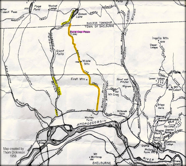
It would be a bit of an overstatement to say that it has been "four score and seven years ago" since there was an actively maintained hiking trail to Bald Cap Peak (near Shelburne, NH).  But for certain, it has at least been many decades since hikers have been able to reach the ledges on this mountain via a maintained trail. The best I can determine, the former trail to the ledges on Bald Cap Peak was abandoned sometime in the late 1960s or early 1970s.  The route of this former trail is shown on the map below (created by Thorn Dickinson in 1958).
Map created in 1958 showing location of former route to Bald Cap Peak Ledges

In June of this year (2012), the Shelburne Trails Club opened a trail to the ledges on Bald Cap Peak.  The corridor is about 0.4 mile long, and it roughly follows the portion of the old trail that ran from the Peabody Brook Trail to the ledges.

Below is a map which shows the location of the new trail to the Bald Cap Peak ledges.
Map showing location of new Bald Cap Peak Ledges Trail

My friend Marty and I were part of the team that did the final touches to open this new trail.  Since we have a personal connection to this pathway, we both felt a desire to make a return visit to see how the trail has fared over the intervening months since it was opened.  And so, on 10-Nov-2012, we drove to Shelburne and began our trek to the ledges via the Peabody Brook Trail (PBT).

Regarding the PBT, you might have noticed on the old 1958 map shown above that the PBT was once part of the Appalachian Trail (AT).  In 1952/1953, the AT was rerouted to the PBT.  Prior to that, the AT had followed the Mahoosuc Trail from Gorham to Mt. Hayes (and beyond).  The AT was once again re-routed when it was moved from the PBT to follow the Centennial Trail which had been built in 1976.

I make mention of the PBT's connection to the AT for the following reason.   I've travelled the PBT on numerous occasions, but this is the first time that I've spotted what is shown in the composite photo below.  On the left side of the photo is a metal marker embedded in a tree along the PBT corridor.  Shown on the right side of the photo is the image of an old AT marker that I found on the Internet.  My assumption is that the image on the left side of the photo is an old AT marker that was covered over with blue-blaze paint at some point after the AT was relocated.
Metal trail marker along Peabody Brook Trail as compared to marker once used along AT corridor

With that rather longwinded introduction, here are a few snapshots taken during the hike Marty and I did to the ledges on Bald Cap Peak.

Winter conditions are progressing from the mountaintops to the lowlands.  Shown below is a composite photo.  The left panel shows the conditions along the trails for about the first half of our hike.  On the second half of the hike, the trail and the surroundings were snow-covered,  as is shown on the right panel of the photo.
Left panel shows conditions for first-half of hike; right panel shows conditions for second-half

Shown below is the sign at the beginning of the trail leading to the Bald Cap Peak Ledges.
Sign at beginning of trail leading to the Bald Cap Peak Ledges

The next photo shows a scene of some of the woodlands along the route to the ledges.
Some of the woodlands along the route to the ledges

Shown below is a snapshot that was taken from the edges of the ledges on Bald Cap Peak!
 Edges of the ledges on Bald Cap Peak

The view from the ledges is expansive!  It includes a picturesque view of the Androscoggin River Valley, plus peaks in western Maine and in the Carter-Moriah Range, as well as peaks in the northern Presidential Range.   The next few photos provide a sampling of those views.
 Looking eastward along the Androscoggin Valley toward western Maine

Southwesterly view toward peaks in Carter-Moriah Range and Presidential Range

After having lunch on the ledges and enjoying the views, we headed back for the trailhead via the same route that we used for the outbound portion of our trek.  It was late in the day as we made our descent.  This provided a set-up for some dusky scenes as sunset fast approached.   The next photo was taken during the "twilight's last gleaming.  It shows peaks in the Carter-Moriah Range with Reflection Pond in the center of the scene.
 Peaks in Carter-Moriah Range and Reflection Pond as sunset approached

To sum it up, the trail to the ledges on Bald Cap Peak is an impressive addition to the network of trails maintained by the Shelburne Trails Club!  The overall trek to the ledges is approximately 5.4 miles (round-trip), and it involves an elevation gain of about 1,900 ft.