Pages

About Me

My photo
Bethlehem, New Hampshire, United States
E-mail contact: randonneur8@yahoo.com | Facebook: facebook.com/1HappyHikerNH

Text Above Search Box

SEARCH MY BLOG USING TEXT BOX SEEN BELOW:

23 February 2011

Nameless Destinations near Mt. Moriah in the Carter Range

When going on a hike, it's a common practice to head off toward a destination (mountain, pond, waterfall, etc) that has been given a name and appears on map. However, one of the most liberating things I've learned is that a destination doesn't necessarily need to be a named feature on a map. For example, there is no rule that obliges one to hike a trail all the way to the top of a mountain. There is complete freedom to choose a particularly nice spot that is located anywhere along a trail and let that be your final destination. And, for hikers who enjoy off-trail travel, a final destination might involve bushwhacking to a nameless peak or pond.

Several nameless destinations near Mt. Moriah were the focus of a recent adventure undertaken by Steve and me on a sunny February day when the air temperature never rose above freezing! However, there was a time back around 1895 when the temperature in this area was sizzling as a raging forest fire consumed over 4,000 acres in the Moriah Brook Valley and along the southeastern ridge of Mt. Moriah. Fires such as this cause tragic losses to flora and fauna, and then erosion washes away much of the soil that might have supported reforestation. Every responsible person abhors the devastation caused by massive forest fires. However, it is somewhat ironic that the destructive fires of the past served to create the views that are now so enjoyed at popular destinations such as Mt. Chocorua, Mt. Crawford, the Moats, the Baldfaces, and many others (including the nameless spots that Steve and I visited). 
[NOTE: If you're interested in additional historical information about forest fires in the White Mountain National Forest, there is an excellent paper written by Christine Goodale that is available by clicking on this LINK.]

We began our adventure on the Stony Brook Trail which is located on Rt. 16 just outside of Gorham.  This 3.6 mile trail begins at an attractive footbridge over Stony Brook, and then terminates high up on a ridge at which there is a junction with two other trails, i.e. the Carter-Moriah Trail and Moriah Brook Trail. 

All the trails we travelled had excellent footing.  On the days preceding our trek, many other hikers had tramped out these trails wearing snowshoes, and some had even pulled a flat-bottomed sled laden with supplies for overnight camping. However, the snow on either side of the well-packed trail was very deep. This was particularly evident when we encountered a trail signpost.  The snowpack elevated us such that we were looking DOWN at the signs, whereas normally they are at eye-level or higher.


Once we reached the junction, we made a left turn onto the Carter-Moriah Trail and headed in the direction of Mt. Moriah, although that was NOT our destination. Our target for this particular day was a tier of bare ledges located about 0.4 mile from the Stony Brook Trail junction. These open ledges were also a result of the forest fire of 1895. For a modest amount of effort you are rewarded with impressive views of the Northern Presidentials, as well as a unique view of ridges and peaks in the Carter Range.
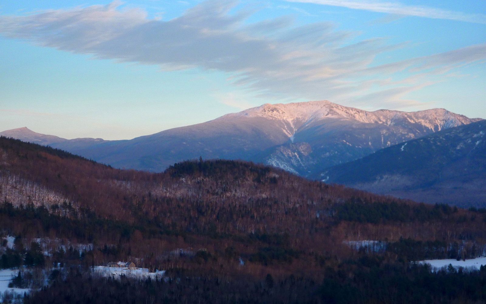
PRESIDENTIALS
CARTERS

Looking eastward from these ledges, there is a magnificent vista of the vast uninhabited area known as the Wild River Wilderness. The ever-impressive Baldface Mountains are also a prominent feature as you look eastward.
[NOTE: If you want to read more about hiking to these nameless ledges along the Carter-Moriah Trail, there is a terrific description with loads of details in the book entitled "Snowshoe Hikes in the White Mountains" by Steven D. Smith.]

While visiting these nameless ledges, we studied the massive display of bare rock and ledges located on the north side of the Moriah Brook Valley. This area would be our next and final "nameless destination" on this fabulous winter day.
We began this next phase of our trek by returning to the trail junction along the ridge.  Here we picked up the Moriah Brook Trail which we hiked for a few tenths of a mile, and then departed the trail for a bushwhack. However, before leaving the trail, we passed through an area of low-growing scrubby vegetation. From here we got an awesome view of the gigantic south cliffs of Mt. Moriah. It sort of resembled a scene you'd expect to see in certain areas of the Western U.S. rather than in the White Mountains of NH!

Once we left the trail we were soon bushwhacking our way through an attractive forest of young birch.

The birch forest eventually gave way to areas of mixed conifers as we approached the first of several ledges that we visited along the way. Since the bushwhacking proved easier than anticipated, we continued upward for a few tenths of a mile to the crest of the ridge where there is an enormous field of bare rock with only a few widely scattered clusters of conifers here and there (see photo below). This huge area was also a result of the 1895 fire mentioned earlier. It covers several acres and is basically a wide-open space that provides sweeping vistas which are simply stunning!

The ledges we had visited earlier in the day along the Carter-Moriah Trail provided a great view into the Wild River Wilderness. However, this open field of rock provided a view of the Wilderness that had an additional grandeur since it was more close-up and intimate, as was also true for the gorgeous view of the Baldfaces and surrounding mountains. We also enjoyed looking back at the cliffs and ledges adjacent to the Carter-Moriah Trail where we had been earlier in the day.

With so few trees to block the numbing Arctic-like wind, we were quickly dissuaded from lingering for very long at this fascinating spot. In a way, this was a good thing. It was late in the day, and we didn't have a lot of time to spare if we wanted to arrive back at the trailhead at a reasonable hour. It was a reluctant departure, but we knew it was time to go. And so, we returned to the Moriah Brook Trail by following the snowshoe tracks we had created during our bushwhack up to the ridge crest. Then, it was a simple matter of linking up with the Stony Brook Trail for the return leg of our journey.

We arrived at the trailhead just shortly after the sun had set. It had been a full day and an enjoyable day. Although the destinations we visited were lacking a name, they certainly were not lacking in beauty!

20 February 2011

Exploring Alternative Locations for Doing Some Rambling

On a busy President's Day weekend, I decided to do some "crowd avoidance" by staying away from the popular hiking trails. It seemed like a good opportunity to explore some alternative destinations by going for a ramble on a few of the public properties that have been established under the Ammonoosuc Conservation Trust (ACT). Details about the mission of ACT, as well as several photos are contained at their website http://www.aconservationtrust.org/.

The properties I chose for this outing were: Herbert G. Whipple Conservation Area; Foss Forest; McCornack-Evelyn Forest, which are circled in red on the map below.  These are all located in the Sugar Hill, NH area.


The Whipple Conservation Area:
My first stop of the day was at the Whipple Conservation Area. It consists of 20 acres that are located on Route 117 just up the hill from Polly’s Pancake Parlor. The general public is welcome to enjoy the land for walking, skiing, snowshoeing. The land was cleared about 200 years ago and much of it has been maintained as field ever since. The property also abuts a large beaver pond and marsh, much of which is part of the conservancy land.

Although the land hasn't been actively farmed for many years, it has been mowed to provide habitat for field nesting birds and other wildlife. Its native grasses also attracts an unusual variety of butterflies and moths. Motorized vehicles are not allowed on the property, except for mowing and other maintenance.

Unfortunately, there is no designated parking area for this property. I happened to catch a member of the Whipple family at his lovely stone bungalow across the street and just a bit west of the entrance to the property. Permission was granted to park in his driveway. During the season when Polly's Pancake House is open, another parking option might be to ask permission to park in their lot. The signboard at the entrance to this property is located on the north side of Route 117, and is shown in the photo below.
I chose to use my XC skis to tour this property, but it could have just as easily been done on snowshoes. There are a lot of pastoral scenes such as shown in the photo below.

Considering the Sugar Hill location of this property, it's no surprise that there are several nice vistas of the Franconia Range. Yes, many of these vistas also include a house as part of the scene (as shown in the two photos below). However, the houses themselves are quite handsome.  At least for me, they didn't detract from the overall viewing experience.


Besides the high peaks in the Franconia Range, there are also views toward the Presidential Range. The slightly zoomed photo below shows such a view.
While I was there, I took the full tour by including a very enjoyable ski down to the beaver pond. At this time of year, it had a somewhat limited appeal, but possibly in warm-weather months it has more robust beauty and charm. Below is a snapshot of the beaver pond.

Foss Forest (and McCornack-Evelyn Forest):

My next stop for the day was the 85-acre Foss Forest which lies in an area between Pearl Lake Road and Post Road in Sugar Hill, NH. This forested area has trails on old logging roads and other trails built by ACT volunteers and neighbors. Some of the trails lead into the MacCornack- Evelyn Forest and also onto the Bronson Hill Conservation Area. All told, ACT has over 300 acres of permanently conserved land in the Pearl Lake/Post Road vicinity for all to enjoy.

There are no signs to let you know when you've crossed from the Foss Forest to the MacCornack- Evelyn Forest. I think that some of the snapshots I took of the Franconia Range were from the MacCornack- Evelyn Forest, but I'm really not certain exactly which of the two forest properties I was on at the time.

For the Foss Forest, there is a small parking lot that is located on Pearl Lake Road about 0.5 mile from the intersection of Post Road. This lot was plowed on the day of my visit.  There is what appears to possibly be another parking area to access this property from the end of Post Road, but from my explorations thus far, I think the parking situation on Pearl Lake Road is the better of the two options.

Just a short distance from the lot on Pearl Lake Road, you come to the sign shown in the photo below.
Carl Schaller of Littleton, N.H. is one of the North Country’s most beloved and tireless leaders in conservation and environmental issues. Among Carl’s numerous contributions are starting the Littleton Conservation Commission and launching the area's first Earth Day celebration. Carl is an Episcopal priest. He was rector of All Saints in Littleton for 27 years and has served other local congregations since his retirement from full time ministry. In January 2011, ACT honored Carl by naming a trail after him which he helped build.

The Carl Schaller Trail appears to be a multi-use trail for XC-skiing, and for hiking/snowshoeing. The XC parts are marked with green diamonds as shown in the photo below. And, judging from the well-laid snowshoe track (and lack of XC tracks) it appears that those portions of the trail for snowshoe use are marked with funky purple/pink streamers. I suspect that maybe this trail is still a work in-progress. Maybe there will be more permanent blazes in the future.
I skied for a bit on the portion of the trail marked with green diamonds, but skied back to my car once the terrain became too challenging for my current skill-level. Upon returning to the car, I strapped on my snowshoes and headed uphill following the well-trodden snowshoe track. I ventured off the track at one point near the height of land to follow an old snowshoe track that looked like it would lead to a view. My hunch was right! Unfortunately, it was late in the day and so the snapshots below probably don't do justice to the vista from the open field where I stood to take the photos.


Overall, I was pleased with my ramblings on the ACT properties. I'll be eager to explore some of their other properties, and equally eager to pay a visit to these properties in other seasons of the year.

17 February 2011

Strawberry Hill State Forest (Bethlehem, NH)


This past Thursday (17-Feb-2011), I was unable to get my act together in time to join my friend Steve Smith on a hike in the Franconia Notch area. However, I eventually got moving and spent a delightful hour and half snowshoeing on the trails at Strawberry State Forest in Bethlehem. This property is one of the many NH public lands which by NH law are referred to as "reservations".  There are a total of 201,513 acres of "reservations" in NH which are randomly distributed over 221 individual properties located in 145 towns.  These include but are not limited to: State forests, State parks, natural areas, historic sites, geologic sites, recreation trails, memorial areas, fire towers, wayside areas, heritage parks, resource centers, certain agricultural areas, State Forest nurseries, fish piers, administrative facilies, information centers, demonstration forests, certain islands, and lands under lease to the department.

The Strawberry Hill State Forest property consists of about 53 acres. The most convenient access point is at the end of Strawberry Hill Road where there is a small parking lot which can accommodate about 3 cars.  This State Forest has about 300 ft of frontage on Lewis Hill Rd (0.3 mile from its junction with Rt 302), however there is no public parking available at this location.  Also, there is a road named Berkeley St. that passes through the State Forest property.  However, this is the access road to the Bethlehem water reservoir which is private property.
Although the Strawberry Hill property is public land, it is a facility that is sort of a local "secret". The hiking trails on this property are unofficially the domain of the local people, and I suspect that trail maintenance is entirely done by the locals. It would be surprising to me if there were any State funds available for trail maintenance at this facility. On an occasional basis, I've hiked the trails in all seasons of the year. It appears to me that they receive their heaviest use during the winter months. Throughout most of the snow season, the trails are broken out by snowshoers.

The Strawberry Hill property is surrounded by private land. In many places, there are poorly marked boundaries between State land and private land. Especially in winter, I suspect (but don't know for a fact) that some of the improvised snowshoe trails might briefly cross onto private land. However, I've not seen any "posted" signs along any of these trail corridors.

My trek this past Thursday began at the parking lot at the end of Strawberry Hill Rd. It was well plowed, and I was the only one there.

The trails are not blazed. You simply follow the worn treadway during the warm-weather months, and follow the snowshoe track that is laid down during the snow season.  Once you've been there a few times, you get the "hang of it", and you know where the trails are and where they lead.
Within about 15 minutes from leaving the trailhead, I arrived at the uphill pitch that leads to a very nice viewpoint.
The viewpoint at the top of the hill is one of the places that I suspect MIGHT be outside the boundary of the State Forest. (If I can remember, I'll take my GPS with me on my next trek to this area. I'll mark a waypoint and then download it to a map to determine if this location is on public land.)  REGARDLESS, the view from this spot is quite respectable!

Cherry Mountain and a portion of the Presidential Range is visible.
There is a view toward Mt. Aggasiz.
A portion of Mt. Garfield is visible.
From other points along this little trail system, there are some tall and stately birch trees.
And, there is even a little brook to make the experience complete!


This is a delightful little hike which should remain a "local secret". I feel it's unlikely that my blog will result in any influx of "outsiders" to this location. Most likely, the few folks who read this accounting will have some ties to the local area, and they might find it interesting to read about one of the many hidden gems located within the little Town of Bethlehem.

14 February 2011

Hiking by Wandering Around!

One of the best selling and widely read business books is entitled "In Search of Excellence" by Tom Peters and Robert Waterman. A principle set forth in this book is dubbed MBWA (Management by Wandering Around). This concept basically espouses that Managers can benefit from periodically straying from their familiar paths and spending time wandering around to their employee's workplaces. The theory is that this will enable the Manager to become more attuned to their business by gathering insightful information from those at the grassroots level.

Perhaps it is a bit of a leap to equate hiking to the business world. However, I do feel that that there is something positive to be said about "hiking by wandering around". Call it HBWA, if you will! Some of my more memorable hikes have been those where I've wandered from the more familiar paths to launch explorations along paths less traveled. One such journey was a recent trek to various destinations off the Zealand Road which is located just south of the junction of Routes 3 and 302 at Twin Mountain.

Many folks (including me) seldom make side-trips off the Zealand Road. A common routine is to just steadfastly travel the entire 3.5 mile length of the road until it ends. From there, treks are launched to destinations such as the Zealand Hut and well beyond. However, on my recent journey, I broke from my traditional ways and did some wandering to various locations along the first mile of the roadway. This adventure was another occasion where I utilized a combination of cross-country (XC) skis and snowshoes. However, to do a journey similar to what I'm about to describe, one could just as easily use only one set of footwear, i.e. either XC-skis or snowshoes. Regardless of your choice of footwear, you will need to start off by carrying whatever it is! As many readers know, in winter months, you need to park your car at the lot on the north side of Route 302 and then walk 0.2 mile westward to reach the entrance of Zealand Road.

My "hiking by wandering around" began just shortly after I sat foot on Zealand Road. I stepped into my XC-skis and headed off the road onto the Flat Iron Ski Trail. This 1.3 mile trek is short but sweet. One segment winds its way through a lovely conifer forest.
Another section of the ski trail hugs the bank of the Zealand River where the snow-covered boulders in the riverbed resemble huge puffy marshmallows.
And if that isn't enough, there is also a clearing along this trail that provides a unique view toward Mt. Hale, plus North and Middle Sugarloaf Mountain.

And although I'll neither condone nor condemn, I'll simply state that XC-ski trails such as this are also travelled by respectful snowshoers who stay well off to the side of the trail.

Upon completing the first of my side-trips, I returned to the main road and continued only a short distance before I left the road again to wander around the Sugarloaf Campgrounds. Although there are no grand vistas from this location, I found it enjoyable to briefly meander around. In some ways it almost seemed liked walking along the streets of a ghost town. You can conjure up images of bonfires, tents, children, and folks of all ages enjoying camping out here during the warm weather months.

I left the "ghostly" atmosphere at the campgrounds and headed further down Zealand Road to area known as the Wildlife Pond. From various locations in this vicinity there is some very pleasant scenery, such as the westward view toward Middle and North Sugarloaf Mountain. The expansive bare-rock cliffs on Middle Sugarloaf are particularly evident from here.

There is also quite a sweeping vista looking eastward. Mt. Tom is prominent on the distant horizon, and off to the left is the south-facing side of the Rosebrook mountain range. Over the crest of this range, and out of sight, is the popular Bretton Woods Alpine Ski area.

Also incorporated into my wandering journey was a trek to North Sugarloaf. But in keeping with the spirit of taking routes less-travelled, I opted not to use the conventional Sugarloaf Trail from Zealand Road. Instead, I skied and snowshoed my way up the mountain via a combination of old logging roads and former hiking-trail remnants. Regardless of how you get to North Sugarloaf, the views are enormously rewarding. When using the conventional hiking trail, there is a wonderful vista immediately upon breaking out of the trees onto a ledge. But don't settle for that! Sometimes in winter it's difficult to see that the trail angles to the right and leads to wide-open ledges that provide stunning views in nearly every direction. However, the trophy-view from here is definitely the Presidential Range! In my opinion, the view of the Presidentials from North Sugarloaf (as well as Middle Sugarloaf) is one of the best in the Whites!

My visit to North Sugarloaf was the last stop for a very fruitful day of wandering to areas less travelled. En route back to my car it occurred to me that the worth of this type of journey is captured in a famous poem by Robert Frost entitled "The Road Not Taken". Although it's possible to interpret the poem in different ways, perhaps one interpretation might be that in both the business-world and the hiking-world there is a definite value to be derived from wandering off in new directions.