Presented below is a composite photo that shows a frontal and side view of Rollo Fall.

Rollo Fall is now on public land since it recently became a part of the Randolph Community Forest. When this report was written, there was a link containing more details about the history of this property (click HERE).
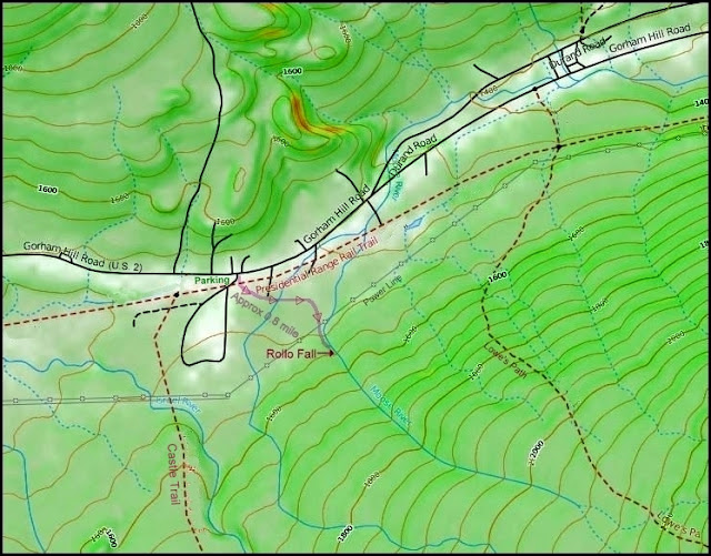
At the time of my visit, in early March 2016, there was no signage directing you to the waterfall, and it's unknown if there are plans to eventually erect signage. Regardless, just park at the Castle Trail parking lot, then walk across the Presidential Range Rail Trail, and then hang an immediate left onto a wide corridor that heads eastward. The corridor eventually turns south, then passes under the power lines and continues onward to the west bank of Moose River where a pathway leads to the waterfall. The total distance from the parking lot to the waterfall is approximately 0.8 mile.
(PLEASE NOTE: This report was written in 2016. As of August 2018, the approach route to Rollo Fall has been slightly modified, as described below.
From the trailhead parking lot at Bowman, head east on the Presidential Rail Trail (toward Gorham). You will pass a gate and then very shortly there will be a sign on your right that directs you to the trail leading to the falls.)
Shown below is a map which might be helpful in guiding you to Rollo Fall. And following the map is a photo which might also be helpful in getting you headed in the right direction from the parking lot.


For those who enjoy history, it might be of interest to know that many years ago, Rollo Fall was on the Lowe's Path corridor, as seen below on the trail map from the 1940 edition of the White Mountain Guide. (The current-day route of Lowe's Path is located several tenths of a mile east of the old route.)

The next three photos are miscellaneous snapshots related to this trek which might be of interest.
 |
| View of peaks in the Presidential Mountain Range as viewed from the parking lot for the Castle Trail (where the hike to Rollo Fall begins). |
 |
| View along the wide corridor leading to Rollo Fall. Snapshot taken where corridor begins to leave its eastward track and head southward. |
 |
| View overlooking a wetlands area toward Mt. Randolph. This vista required a short bushwhack off the corridor leading to Rollo Fall. |
~ THE END ~

No comments:
Post a Comment