
Perhaps
a new term is being coined here, i.e. "un-blog-worthy"! That term is how I would characterize the
hikes that I've been doing over the past several weeks. Therefore, I'm dusting off an old report
about a trek that I did back in September 2010.
So, here goes!
Looking
at a topographic map, there is a 2,941 ft peak that is situated nearly due east
of the Wildcat Ridge and nearly due west of North Baldface. It is unnamed on many topographic maps, but
some peak-baggers refer to this mountain as "West Peak, North
Baldface". However, I think of it
as simply West Baldface.
I
decided to visit this little mountain not for peakbagging purposes, but rather
because it would be something different to do, plus it looked like a good spot for
some interesting views, particularly of the Baldfaces.
My
trek was launched from the end of East Branch Road (near Slippery Brook Road in general vicinity of Jackson, NH). I hiked
northward along the East Branch Trail for several miles before turning eastward
to follow old logging roads for another mile or so. Eventually, I left the logging roads and
bushwhacked up the west slope of West Baldface. It was an easy bushwhack through ferns, birch
and other hardwoods.
My
route of travel is depicted on the map shown below. It's not the greatest map, but at least it
shows the hiking trails, as well as the old logging roads in this area.
 |
| My route of travel is highlighted in yellow on this map |
There
is no single spot on the summit where there is a 360 degree view, but views in
all directions are available by moving around from spot to spot on the summit
area. Below are some photos from this
trek.
 |
| Looking eastward toward North and South Baldface |
 |
| Looking westward over Wildcat Ridge toward Mt. Washington (on horizon at top/center) |
 |
| Looking northward toward the rocky ridge of Mt. Moriah that extends into the Wild River Valley |
 |
| Looking southward toward peaks in the Sandwich Range and other surrounding mountains |
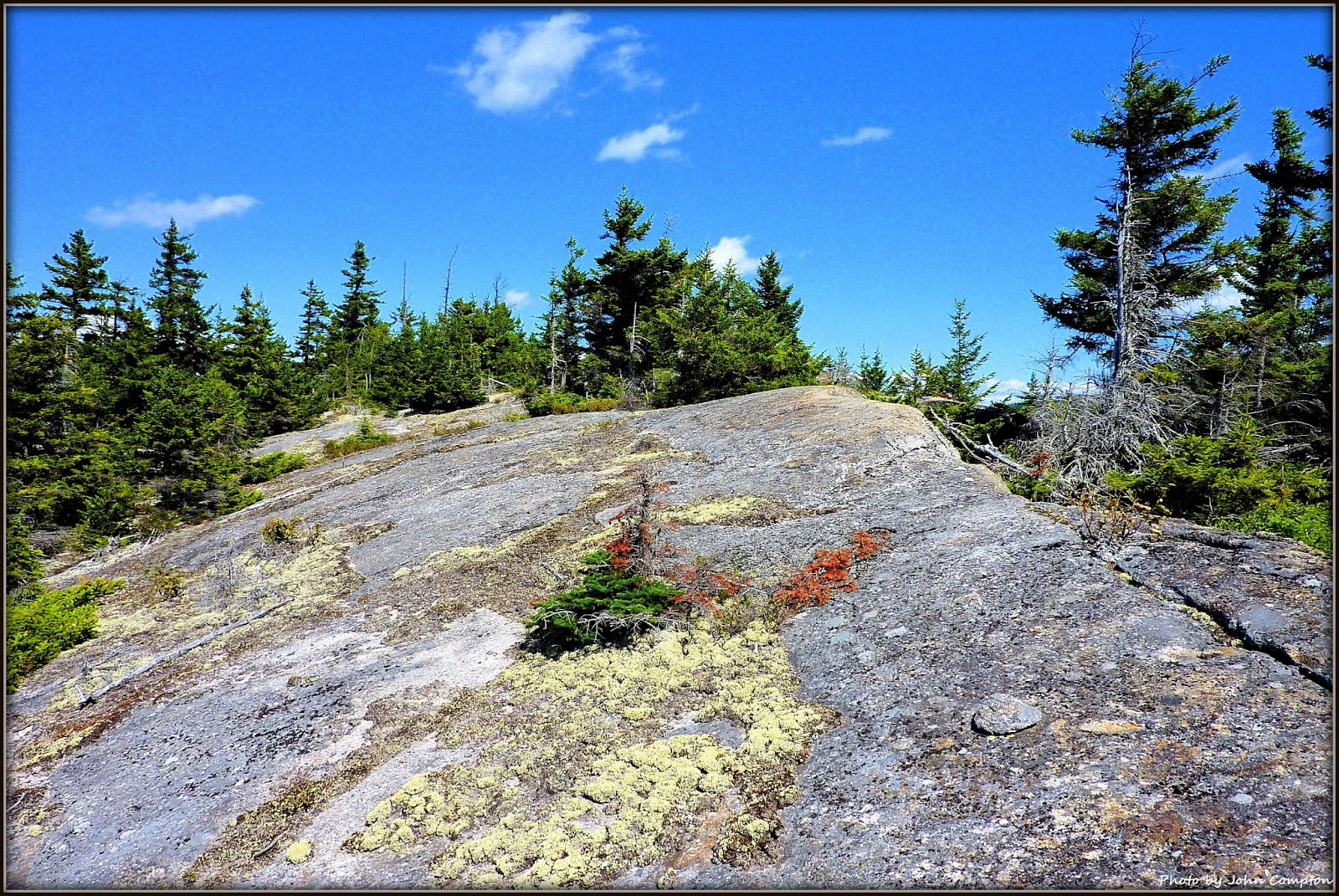 |
| Summit area of West Baldface |
 |
| The East Branch was flowing in many spots, but at other spots, it was very still and "reflective". |
This
was a relatively easy trek since most of it was done either on-trail or on old logging
roads, both of which were relatively flat with just an occasional slight pitch
here and there. The only significant
climb was the short bushwhack between a logging road and the top of West
Baldface. I would roughly guesstimate that
the hike was about 10 miles round trip.
To sum it up, this trek was done
before Tropical Storm Irene which caused significant erosion in this area. And as a result, it might now be challenging
to travel portions of the route that I used for this hiking adventure.
7 comments:
Outstanding! I've read trip reports about this peak, but I don't think I've seen photos before. Do you know if there is any way to pick up the old trail that went over Sable and Chandler from the East Branch? I'm not even sure if there's enough left to follow, but I've read about bits and pieces.
Nice oldie but goodie, John! When a friend and I went there in the 90s we didn't know it was on a list and were surprised to find a jar. We found a moose antler and dubbed it "Antler Ridge." Another cool spot is the ledgy, flat-topped knob just to the NE, which has good views into the Wild River valley. Wouldn't mind going back there...
Steve
Hi Ken . . . glad you liked the report.
Regarding the old Sable Mountain Trail that once traversed Mts. Sable and Chandler, I have no firsthand knowledge about this trail. However, I’ve read reports where folks reported spotting an occasional cairn, and remnants of a faint corridor that could have been the old trail. Based upon the following quote from AMC’s 1940 edition of the White Mountain Guide, it doesn’t sound like it was ever much of a trail, even “back in the day”:
“Mounts Sable and Chandler may be reached from Jackson via the E fork of the East Branch. The trip, largely without trail, is difficult and should be taken only by those experienced in woodcraft. A better approach to Mt. Sable is from So. Baldface.”
There was another trail in this vicinity named the South Baldface Trail. From a point near the summit of South Baldface, this trail ran westward to link up with the East Branch Trail. But once again, I have no firsthand knowledge about this old trail, nor have I ever read any reports about it.
Most likely, you’ve already looked at vintage topographic maps which show these abandoned trails. But if not, below is a link that can be cut and pasted into your browser:
http://docs.unh.edu/NH/cnwy45ne.jpg
John
Thanks Steve!
Aha! Just took a look at Google Earth, and am pretty certain that I spotted that “ledgy, flat-topped knob just to the NE” that you mentioned in your comments. It does indeed look interesting. There are so many places to explore in the Wild River Wilderness, and Baldface/Royce Range! Wish it was a shorter drive to get there! :-)
John
Yes, I love those maps. :) Thanks for that info, very informative. Perhaps I will poke around a bit out that way next year. I love that whole area, but it's a far drive from central MA!
Again, nice mountain views on a beautiful autumn day. Even if it was five years ago! Hard to believe that there are too many unnamed mountain peaks out there anymore. The reflection in the river photo is very nice.
John, it's hard to believe that any of your hikes are un-blogworthy—from what I can see you always find scenic and interesting places to go!
Thanks for taking time to view my blog, and especially thank you for your kind comments.
John
Post a Comment