
Living
in northern NH, it's a relatively straightforward matter to take short trips to
hike the mountains of ME, VT, NY, and even across the border into Canada. Recently, my wife and I did a short loop
through Canada that took us to two locations: 1) Mont Owl's Head, and 2) Le Parc
National du Mont Megantic.
The
map shown below will provide a general overview of our route of travel.
 |
| Our route of travel for our visit to Mont Owl's Head and Le Parc National du Mont Megantic (Click/tap on map to enlarge) |
1) MONT OWL'S HEAD:
Mont
Owl’s Head is located on the western shore of Lake Memphremagog in the Eastern
Townships of Quebec near the town of
Mansonville (about 12 miles over the Canadian border from North Troy, VT). Besides offering some of the best alpine
skiing in Quebec, this mountain also has a number of seasonal hiking trails developed by Missisquoi Nord in
partnership with the Owls Head Ski Resort.
 |
| Hiking Trails on Mont Owl's Head |
As
we had hoped, our visit to Mont Owl's Head occurred near the peak of the Autumn
foliage season. The next 6 photos show some of the many colorful scenes that
were experienced from various spots along the hiking trails.


From one of the ledges on
Mont Owl's Head, I was able to capture a vista looking across the U.S./Canadian border and see mountains in
Vermont's Willoughby Gap area, and also see high peaks in White Mountains of
NH.
 |
| Highly zoomed photo looking across U.S./Canadian border and seeing mountains in Vermont's Willoughby Gap area, as well as high peaks in White Mountains of New Hampshire |
In
the evening after hiking the trails on Mont Owl's Head, there was a totally
unexpected treat! We had the rare
opportunity to experience alpenglow
on autumn foliage. Alpenglow only lasts for a few precious
seconds. We just happened to be at the
right place at the right time. And more
importantly, we had a camera to capture "the moment"!
 |
| Alpenglow on Autumn foliage at Mont Owl's Head |
Here
is a tidbit of trivia associated with Mont Owl's Head. In the 1880's the luxurious Mountain House
hotel was built on the shore of Lake Memphremagog at the foot of Owl's
Head. The hotel burned in 1899 and was
never rebuilt. However, when it was in
operation, there was a hiking trail from the hotel to the summit of Mont Owl's
Head. Although I'm unable to verify it,
I'm told that remnants of this old trail are used by segments of the current
day trail named Sentier Panorama. While
hiking the upper portions of the Sentier Panorama, I spotted occasional faded
red blazes, and I wondered if perhaps these could possibly be markings from
that old trail.
 |
| On upper portion of Sentier Panorama trail, there were a few faded red blazes which might have been holdovers from an old trail from the late 19th century. |
 |
| A placard along the Sentier Panorama trail |
2) LE PARC NATIONAL DU MONT MEGANTIC:
When
viewed on a relief map, it becomes obvious why the Mont Megantic area is
considered as a good example of one of the circular mountain formations on the
east coast of North America that are of volcanic origin and known as ring
dikes.
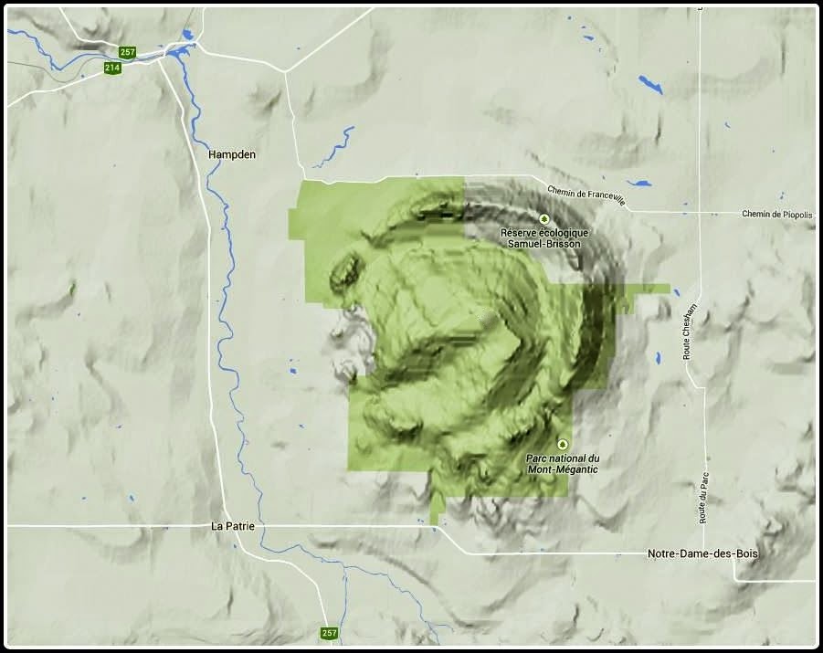 |
| Relief map showing mountains within Le Parc National du Mont Megantic |
The
mountains of Le Parc National du Mont Megantic dominate the area near the
Quebec village of Notre-Dame-des-Bois (less than 25 miles over U.S./Canadian
border).
 |
| View of Mont Megantic mountains from the Quebec village of Notre-Dame-des-Bois |
There
are maintained hiking trails to the Park's 3 main summits: Megantic (3,625 ft);
Saint Joseph (2,877 ft), and Victoria (2,866 ft). Two of those summits (Megantic and Saint
Joseph) can be reached via auto road. (On this trip, my wife and I "cheated"
and took the auto road!)
The
main summit (Mont Megantic) is part of the International Dark Sky Places Program which promotes preservation and protection
of night skies across the globe. Located
on this mountain is the Mont Mégantic Observatory which is the first such site
to be recognized (in 2007) as an International Dark-Sky Reserve.
 |
| Mont Megantic summit as viewed from Mont Saint Joseph |
On
the summit of Mont Saint Joseph is a rustic Jesuit chapel which was erected in
the 19th century to receive the patron saint’s protection against the strong
winds and storms common to this region.
 |
| Chapel erected in 19th century on Mont Saint Joseph to receive patron saint’s protection against strong winds and storms common to this region |
On
the day of our visit, it was very overcast with occasional rain showers. But even though viewing conditions were less
than ideal, there were still some nice vistas, and it was well worth the trip.
 |
| A viewing station on Mont Saint Joseph |
To sum it up, it difficult to
believe that 5 years have passed since last visiting the Eastern Townships of
Quebec (click HERE to read my report
about that trip). This most recent trip
has inspired us to make more frequent visits to Canada in the upcoming years.
4 comments:
Beautiful! Le Parc National de Mont Meguntic has been recommended to me as place to visit, but your pictures really bring it to life and will be put on my list of places to visit.
I agree with Summeset—beautiful! And I can't believe these two wonderful hiking areas are so close to your hometown of Bethlehem, NH Oh, I also love the use of the relief map; it really shows the circular, volcanic origin of Mont Megantic.
The fall colors are amazing and Lake Memphremagog is quite scenic. I read your October 2009 report and it's also a great post. It looks like you and Cheri had a very nice vacation north of the border.
You're right, John,—you'll have to make more trips to Canada in the coming years!
Thanks Summerset! As you might already know, for U.S. and Canadian citizens, crossing the border is usually about as easy as stopping at a toll booth. Assuming, of course, you have a valid passport and aren't transporting anything that might delay the process, like weapons, etc! :-)
It can be a bit intimidating when you cross over the border into Canada and suddenly have road signage in French, and the metric system being used for distances and speed limits. Also, everyone you meet is speaking French. However, no matter where we met a Canadian (on the trail, at a retail establishment, etc), if we spoke to them in English, they conversed with us in English. I'm so envious of their ability to effortlessly flip back and forth between French and English.
John
Rita, thanks so much for taking time to read this blog, as well as the report of our Canadian trip in 2009.
Regarding making more trips to Canada, in the recent past we sort of tippy toed into the Canadian Maritime Provinces. Next year we hope to further explore that area. However, it will certainly take us much further afield than our scamper across the border into the Eastern Township area of Quebec. Now of course, if one really wanted to do some unique Canadian explorations, then the territory called Nunavut would be a place to consider. It's really out there! Below is a link, in case you might be interested.
http://www.nunavuttourism.com/
John
Post a Comment