
Without a shred of doubt, my top pick for hikes
done in 2013 was my trek to Tumbledown Mountain in the vicinity of Weld, ME. The photo below is just one of the many taken on this hike. It shows Tumbledown Pond as viewed from edge of a small tarn along the Parker Ridge Trail. (Click HERE for the complete set of photos from this trek.)

Regarding my other outings for 2013, I logged a
total of 158 outdoor adventures (includes hikes, as well as X-C skiing). It was a challenge to narrow these down a
reasonable number of favorites. Regardless,
listed below (by calendar month) is the selection that was finally chosen to be
my favorites for 2013.
New
Year's Day: Cross country skiing on the Mooseway Trail at Pondicherry

Early
January: Mt. Willard as viewed from Sam Willey Trail

Mid January: Zoomed view from Jennings Peak showing Mad
River Notch with portion of East Osceola on left, cliffs on west knob of Mt.
Huntington in center, and portion of Mt. Kancamagus on right.

Early February: Bushwhack to
beaver pond complex in Otis Brook drainage (located between Rocky Branch
River and Iron Mountain). Photo shows me
having lunch at the beaver ponds (north end of Iron Mountain is in background).

Mid
February: Found an intact moose antler while trekking on Reel Brook
Trail for a day hike to Eliza Brook Shelter.

Late
February: Trek to Mt. Monroe. A
heavy cloud cover remained on the high peaks, despite some forecasters who had
predicted otherwise. Still an enjoyable
and memorable hike, but only got one worthwhile snapshot looking down the
Ammonoosuc Ravine.

Early March: Got some
BIG views from a very short hike (less than 0.5 mile round-trip) to an old
logging clearing at Fay State Forest (Lincoln/Woodstock, NH). Particularly liked eastward vista of peaks
along Kancamagus Highway corridor (Loon Mtn ski slopes on right).

Mid March: A bushwhack to various ledges and
viewpoints in Mt. Langdon area. A recent
rain followed by sustained temperatures below freezing had created a hardened
snowpack that was ideal for bushwhacking. Could walk on top of the snow without
sinking. Much the same way as walking on
a paved surface!

Mid
April: A loop hike to Mt. Crawford involving a bushwhack approach to
the summit from the west. Photo shows Stairs Mountain with Mt. Resolution to its immediate right.

Late
April: A bushwhack to South Sugarloaf (Zealand Road area). Photo shows Presidential Range on the
horizon.

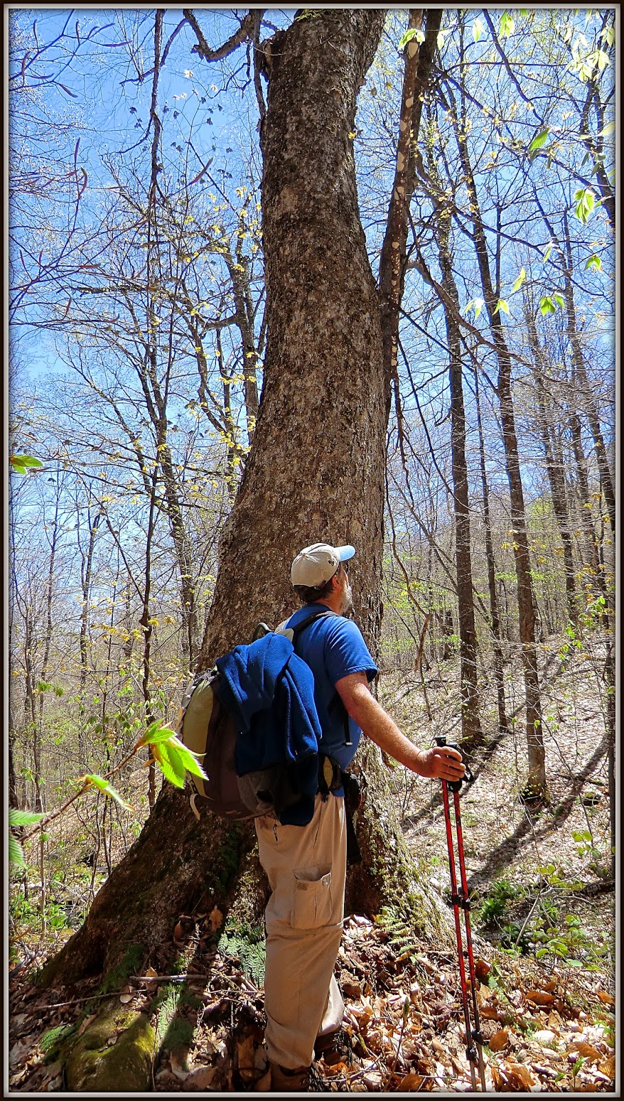
Early
May: A bushwhack off the Haystack Notch Trail with Steve Smith. Among many interesting things, we saw several
large hardwoods, some of which might be over 150 years old. Photo shows Steve admiring one of these large
trees.
Mid
May: A bushwhack to a cliff at east end of Mt. Tremont. Photo shows southeasterly view
featuring (left to right) Bear Mountain, Mt. Chocorua, Mt. Paugus.

Late
May: Memorial Day weekend in the Adirondacks with wife Cheri. Photo shows raging cascade
along West Branch of Ausable River

Mid
June: Hike to Rogers Ledge with my friend Marty. Photo shows Square Mountain and
Greens Ledge, as viewed from an off-trail ledge located just below and east of
the Rogers Ledge summit.

Mid June: A loop hike involving old logging road, a
bushwhack, the Mahoosuc Trail, and the Centennial Trail. Photo shows a view of Presidential Range from ledges on
Cascade Mountain.

Late
June: A bushwhack to an old lead mine, and an unnamed cascade in the
Lead Mine Brook drainage. Photo shows
the unnamed cascade which is a bit unusual in that the brook makes an abrupt 90
degree turn at bottom of cascade.

Early
July: A trip to Rangeley, ME for hikes in region of Saddleback
Mountain. Photo shows The Horn as viewed from a tarn in the col between Saddleback Mountain
and The Horn.

Mid
July: A bushwhack to a small unnamed pond off the Hancock Notch
Trail. While en route, did a short side
trip to get a view of The Captain.

Early
August: A bushwhack to East Hale.
Photo shows Zealand Notch with Mt. Carrigain and
neighboring peaks in the background.

Mid
August: A bushwhack to top of Eagle Cliff Ridge (Franconia Notch). Photo shows a vista from the south end of the
ridge looking southward down I-93 (Cannon Cliffs at
center right; Profile Lake at bottom right).

Early
September: My very first hike to New Hampshire's Mt. Monadnock. Photo taken as I was approaching the summit.

Mid
September: My very first hike in the Bigelow Mountain Range. Photo taken from Cranberry Peak looking eastward along the Bigelow Range toward
Cranberry Pond and The Horns.

Late
September: A bushwhack with Steve Smith to Little Tunnel Brook Ravine (located
on north side of Mt. Moosilauke). We saw
many, many cascades along the route. The
photo shows the "grand prize" which
is probably about 100-ft high. And
although this torrent of water is quite striking, it is unnamed!

Early
October: A traditional hike to Mt. Pierce via Crawford Path. The photo shows the view from the top of Mt.
Pierce looking toward the Presidential Range. The colors were so vibrant and surreal on this particular October day!

Mid
October: A bushwhack to The
Hogsback in the Benton Range. The photo
shows a vista of Long Pond with
Kinsmans and tops peaks in the Franconia Range in background.

Early
November: A bushwhack to Cape Horn (Groveton, NH). There are many picturesque and interesting
views from the ridgeline along Cape Horn.
However, my favorite image from this trek was the vista of Cape Horn itself
as I approached it while en route.

Mid
November: A hike to Mt. Cube via Cross Rivendell with my friend
Marty. The photo show a vista from North Peak. Upper Baker Pond is
in foreground; followed by Mt. Moosilauke on horizon.

Early
December: Had several
enjoyable hiking experiences in early December by poking around the recently
established Cooley-Jericho Community Forest located in Easton, NH. Photo shows a trailside vista looking northward toward
Vermont.

Christmas
Eve: Hiked to Bog Ledge in northern
Presidential Range using the following trails: The Link; Cliffway; Monaway;
Amphibrach. Photo shows King
Ravine as viewed from Bog Ledge.

End
of December: A loop hike to Middle and North Sugarloaf with my friend
Marty. Loop began and ended at parking lot for Twin Mountain Recreation Area in
the town of Twin Mountain. This hike incorporated: a segment of
the old Glacial Ridge Road; a snowmobile trail; a portion of the Trestle Trail;
entire length of the Sugarloaf Trail; and remnants of the Baby Twins Trail
(abandoned long ago). Photo shows a
vista from Middle
Sugarloaf that includes a portion of Zealand Valley with Mt. Tom and Mt. Field
prominent on the horizon.

~ THE END ~
10 comments:
Wow, John - that's a stunning set of photos from another year of great adventures! I was honored to share a couple of them with you. Thanks for posting!
Steve
Those are very kind words, Steve! Thank you! I also feel honored to have shared some hiking adventures with you in 2013. Hopefully, we will join forces for other mountain wanderings in 2014.
John
Beautiful compilation of photos and all the different places there are to explore. Like Steve said, I'm honored to have shared some of these with you and look forward to more joint adventures.
Marty
Thanks Marty! I’m very appreciative of your flexibility and willingness to accompany me on hiking adventures, including those that are unconventional!
John
Great photo of Tumbledown from Parker Ridge. Tumbledown is one of my all-time favorite hikes, except that I wish it wasn't so darn busy all summer long. Also, your photo of Cooley-Jericho Community Forest is beautiful -- I love the birch trees contrasted with the evergreens. It looks like a beautiful and peaceful spot.
Hi John,
Wow! This is an impressive summary of all your "best of" hikes in 2013. Great pictures! I'm happy to be able to re-visit these great places with you via this post.
Also, I'm impressed with the number of adventures you completed last year. Very inspirational! You're fortunate to live near public lands and trails in a beautiful part of the country.
And, by the looks of your wonderful winter hike two weeks ago (without those noisy snowmobiles—yea!) it seems that you're gearing up for more great adventures in 2014. I'm looking forward to reading about them!
Rita
Thanks Diane for stopping by to take a look at my blog and to post a comment!
Tumbledown is indeed very impressive. It’s easy to understand why it’s so popular and is often a very busy place. I was fortunate to be there at mid week in late September, and therefore I saw very few hikers.
John
Hi Rita,
Thank you for your very kind words about my photos, and a special thank you for being such a faithful follower of my blog.
I think we are both very fortunate to live in such beautiful parts of the U.S. The photos you post on your blog from the Western region of the U.S. are astonishing to me. The topography is so different from what we have here in the Eastern region of the U.S.
John
Beautiful photos! I always keep in mind "WWJD" (what would John do) anytime I' pondering where to hike. Thanks for sharing!
Thanks Lisa! Never thought of it as being an acronym, but actually I employ another “WWJD” principle for nearly all of my hikes. The difference is that my acronym stands for “What WILL John Do” for a hike today? Since I enjoying trying something different for each hike, WWJD can sometimes be a challenge! :-)
John
Post a Comment