
Following an
all-day, off-trail trek in the southern Mahoosucs with folks from the Shelburne
Trails Club, I was in the mood for some less intense meanderings using
established trails! The location I chose
was in western Maine, just a few miles over the New Hampshire border.
During my travels, I checked out several little hikes and walks. However, this report will only focus on my trek to Mount Will, plus a trek that took me to both Bucks Ledge and Lapham Ledge. These locations are all in relatively close proximity to each other as can be seen on the map shown below. (Click to enlarge.)
During my travels, I checked out several little hikes and walks. However, this report will only focus on my trek to Mount Will, plus a trek that took me to both Bucks Ledge and Lapham Ledge. These locations are all in relatively close proximity to each other as can be seen on the map shown below. (Click to enlarge.)
 |
| Circled in pink are the locations of Mount Will, plus Bucks and Lapham Ledges (CLICK TO ENLARGE) |
Hike to Mount Will:
The trail is
fully described at the Main Trail Finder website (click HERE), which includes a trail map, as shown
below.
 |
| Trail map for Mount Will |
I did this hike
as a 3.25 mile loop which includes both the North Ledges and the South Cliffs. The open ledges and cliff tops provide views
of the Androscoggin River Valley, as well as some stand-up views of Puzzle
Mountain and surroundings.
 |
| View of Androscoggin River Valley area from Mount Will |
 |
| View of Puzzle Mountain and surroundings from Mount Will |
Located sort of
midway between the South Cliffs and the North Ledges is a spur trail that leads to the Gray Memorial. Maine State Trooper Leroy Gray, 39, and his
wife, Brenda, 32, were killed when their small plane hit Mount Will at about
7:30 PM on Sept. 25, 1992. Karen Gray (Leroy's
daughter and Brenda's stepdaughter) survived the crash and spent more than
3-hours walking down the mountain to seek help. The funeral for Leroy and
Brenda Gray drew nearly 1,000 people which included more than 800 uniformed law
enforcement officials.
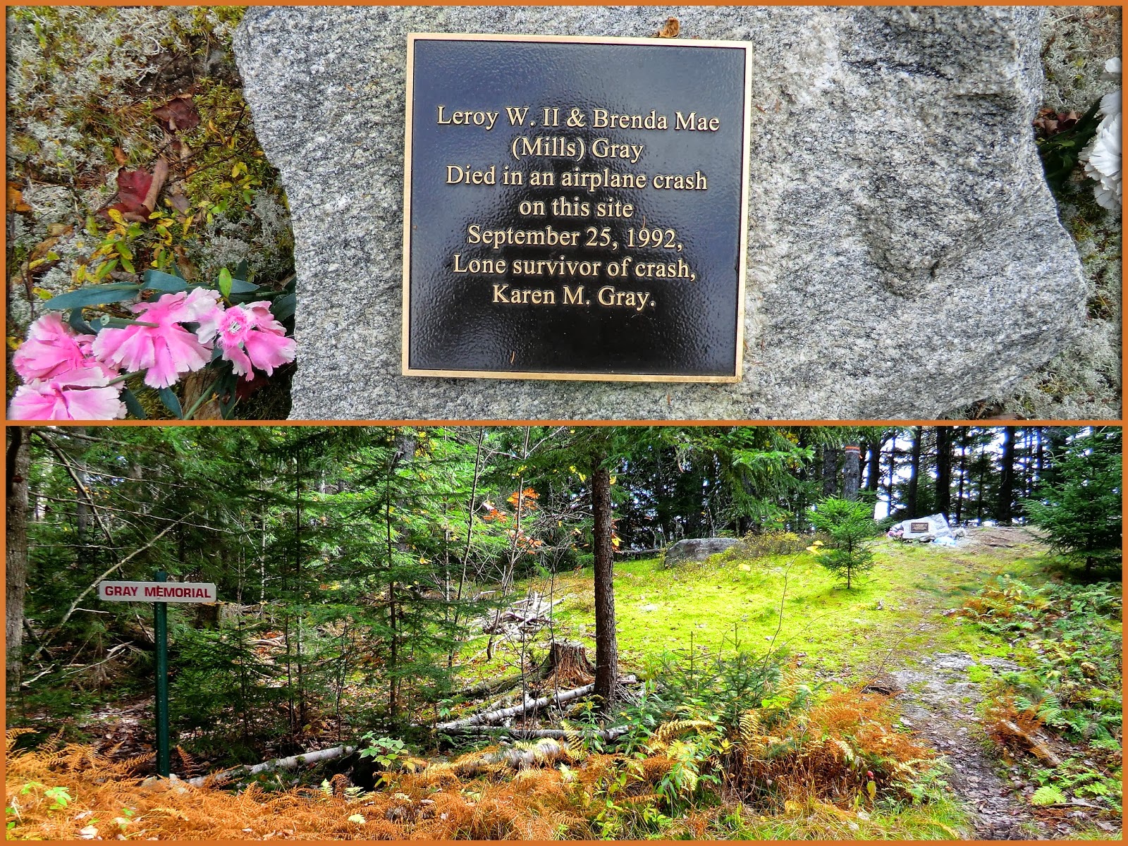 |
| Gray Memorial site located atop Mount Will |
/ / / / / / / /
/ / / / / / / / / / / / / / /
Hike to Bucks Ledge and
Lapham Ledge:
The trail used to access Bucks Ledge and Lapham Ledge is also fully described at the Main Trail
Finder website (click HERE). This website
includes a trail map, as shown below.
 |
| Trail Map for Bucks Ledge and Lapham Ledge |
This hike was done as a 2.8 mile loop. For the return leg
of the loop, it involved a 1.1 mile walk along Mann Road and a 0.2 mile walk
along Rt. 26. The road walk was pleasant
enough. However, for any future hike at
this location, most likely I'll forego the road walk and simply use the same
route for both the outbound and inbound leg of the trek.
It should be mentioned that although the trailhead is located on Rt. 26, it is a bit obscure. On the day of my hike, the only indication of the trailhead was a rather rudimentary sign stuck into the ground on a wooden stake (see next photo).
It should be mentioned that although the trailhead is located on Rt. 26, it is a bit obscure. On the day of my hike, the only indication of the trailhead was a rather rudimentary sign stuck into the ground on a wooden stake (see next photo).
 |
| Rudimentary sign at trailhead for Bucks and Lapham Ledges hike |
Lapham Ledge
provides an enjoyable view of Bryant Pond which lies at the base of Mt. Christopher, as seen on the right side of the
next photo.
 |
| Bryant Pond and Mt. Christopher, as viewed from Lapham Ledge |
Lapham Ledge is definitely worth a visit. But in my opinion, Bucks
Ledge provides better views. From Bucks Ledge, there are excellent views
overlooking North Pond, South Pond, as well as Bryant Pond a bit further to the
southeast. It was difficult to find a
spot that would include all three ponds in a single photo. The next snapshot was the best I could
do. It shows Bryant Pond (far left),
South Pond (far right), and a small piece of North Pond (bottom right).
 |
| View from Bucks Ledge:Bryant Pond (left); South Pond (right); small piece of North Pond (bottom right) |
The next photo
was also taken from Bucks Ledge. The main
intent of this photo is to highlight the dazzling Autumn foliage that was still
present at this location in mid-October.
 |
| Autumn foliage viewed from Bucks Ledge in mid-October (Bryant Pond seen in distance) |
Bucks Ledge also
provides views of peaks in Evans Notch and the White Mountains beyond. However, these views were mostly obscured by overcast
conditions on the day of my visit. Those
peaks can be seen ever so faintly on the distant horizon in the next photo.
 |
| Cloud-obscured vista of peaks in Evans Notch and White Mountains on distant horizon |
The next photo was taken from the roadside of Rt. 26. It shows Bucks Ledge as viewed over North Pond.
 |
| Bucks Ledge as viewed over North Pond |
10 comments:
Fine report on some lesser-known destinations, John! Love the shots of the late foliage over there when the higher elevations are November-drab.
Steve
Steve, thank you for the kind words about the report. Autumn is by far my favorite season of the year. It's always a treat to find lingering pockets of colorful foliage before the forests throughout the region turn to "November drab"!
John
nice report, again! I'm very familiar with these spots, bucks ledge 40 min from my house, mt. will 55 min. I'm a frequent flyer to both, love sunsets at buck's! I like to hike to buck's ledge then I whack across the ridge to the open summit of moody mt., then use a steepish skidder rd facing SE. to connect to the dirt rd. and loop back to my car.
-nate
Nate, thank you for taking time to read my report and post your comments!
Thanks for confirming my suspicions about Bucks Ledge offering the potential for some great sunsets. I'll definitely keep that in mind for future hikes there.
Also thanks for the tip about whacking to the summit of Moody Mountain. That thought crossed my mind, but obviously I didn't do it this time around. Yet another thing to keep in mind for a future hike! :-)
Got a question for you. Is it practical to snowshoe to Buck's Ledge in winter?? Guess more than anything, I'm wondering about the parking situation, and the snowmobile traffic.
John
I've actually never hiked bucks in the winter, the dirt rd, is frequently used by snowmachines, as far as parking, I want to say a small space gets plowed on the side of 26. Nice to see your enjoying some of my closer to home hiking options, what they lack in vertical feet they make up in other ways..
Thanks for getting back to me about my follow-up question to you. Much appreciated!
And yes, I’m enjoying the heck out of my forays into Maine! In terms of vertical feet, I like to choose quality over quantity for my hiking adventures. The ‘quantity’ of vertical feet climbed doesn’t always mean greater ‘quality’. :-)
John
Beautiful pics and area. I have done some hiking behind Philbrook Farm Inn, and this will get added to my "to do list" for future meanderings. I love that area, it is spectacular! Thanks for posting this!!
Hiking Lady
Hi Hiking Lady!
Both hikes (Mt. Will, plus the trek to Bucks & Lapham Ledges) are worthwhile, in my opinion. However, if your time frame is short, then the one that I’d most recommend would be the trek to Bucks Ledge. You might say it offers the biggest “bang for the buck”! :-)
Thanks for reading my blog, and for posting your comments!
John
Hi John,
I'm glad to see that you went back to Maine! Autumn is also my favorite time of year—there's so much beauty and so little time to take it all in. I love your posts because they show and tell me where to find color, should I ever get to New England during the fall season.
Unfortunately, I won't be getting out any time soon to enjoy more fall color hikes. I had right knee surgery on Wednesday (torn meniscus/cartilage) and will have to take it easy for about 6 weeks—hopefully not any longer than that!
Thanks to your blog, I can hike vicariously for the next month or so!
Hi Rita,
You have my very best wishes for a speedy recovery from your knee surgery.
It’s good to read that you’ll enjoy some vicarious hiking via my blog. However, as we both know, there’s nothing quite as satisfying as a first-hand experience.
Thank you for being such a loyal reader of my blog. I’m truly appreciative.
John
Post a Comment