
Throughout the U.S., and certainly here in
New England, there is no shortage of peaks named Bald Mountain. Within the Nash Stream State Forest near
Stark, NH there is a mountain that has been bestowed with this commonly-used
name. I've visited this particular Bald
Mountain on several occasions, and I've tried to make each visit a bit unique
by coupling it with something that is new to me.
For this trek, the "new" component
would be to include a bushwhack to a ledge located near the south spur of Long
Mountain. On prior visits to Bald
Mountain, I've gazed at this very prominent ledge and wondered about it.
Shown below is a photo of the ledge as viewed
from Bald Mountain. (NOTE: Clicking on any photo in this Blog will enlarge and enhance the image.)
 |
| Ledge on south spur of Long Mountain, as viewed from Bald Mountain |
Getting to this ledge turned out to be a
relatively straightforward one-mile bushwhack which was launched from the Bald
Mountain Notch Trail at the base of Bald Mountain's north side. The vast majority of this trek was through
open woodlands. Also, there were several
attractive fern glades along the way, such as shown in the next photo.
 |
| One of many fern glades seen during bushwhack to ledge on Long Mountain |
This is definitely "moose
country". Although I didn't see any
actual moose, their droppings were everywhere.
Plus, I encountered several antler sheds, but none were worth hauling
out of the woods as "trophy pieces" since the local rodent population
had gnawed away huge chucks.
The photo
presented below shows the most intact antler that I came across.
 |
| One of several moose antlers seen during bushwhack to ledge on Long Mountain |
A few paragraphs ago, I said that the majority
of the bushwhack was through open woodlands.
Well, as an offset to this idyllic world, there were several hundred
feet of thick conifers on the final approach to the ledge. The conifers put up a good fight, but with
some effort I was finally able to penetrate their defenses and pop out onto a
small opening at the top of the ledge.
It wasn't a very comfortable spot. It was cramped, and situated directly at the
edge of the steep ledge.
Perhaps the next photo will provide some idea
of my rather precarious perch. This is a
highly zoomed photo of the ledge which was taken from Bald Mountain. The red arrow points to the approximate spot
where I was precariously balanced.
 |
| Red arrow points to my precarious viewing spot on Long Mountain ledge |
The next photo shows the view looking straight
down from where I was "hanging out"!
 |
| Looking straight down from where I was "hanging out"! |
Despite the short skirmish with the conifers,
and my rather uncomfortable roost at the edge of the ledge, the views were very
worthwhile. The vista that I enjoyed is
shown in the next photo. Prominent
features include a piece of Bald Mountain (immediately left of Christine Lake),
Victor Head (small pointy peak to right of Christine Lake), and then South
Percy and North Percy on the far right of the photo.
 |
| View from ledge on Long Mountain |
Up to this point, the primary focus of this
report has been the ledge on Long Mountain.
So, switching gears, here are some details about the Bald Mountain
portion of the trek.
Reaching the summit of Bald Mountain can be achieved
via a pure bushwhack, which I've done. Or,
the easier alternative is to do what I did on this trek, which is to follow a
bootleg trail that begins at the far western end of the Bald Mountain Notch
Trail (about a tenth of a mile or so from the junction with the Rowells Link
Trail).
Earlier in the report, I showed a photo of the ledge
on Long Mountain, as viewed from Bald Mountain.
So in fairness to Bald Mountain, shown below is a photo of it, looking down from the ledge on Long Mountain. (In case
you don't recognize Bald Mountain. it's the green mound immediately to the
left of Christine Lake.)
 |
| View of Bald Mountain (far left, center), as seen from ledge on Long Mountain |
The photo shown above is looking at Bald
Mountain's north face. From this viewing
perspective, the mountain doesn't live up to its namesake, i.e. "Bald". However, the name was most likely given
because of the prominent bare ledges that can be seen on all the other sides of
this mountain.
Once you're on top of Bald Mountain, you can
easily move from one side of the mountain to the other via a short corridor
that is mossy and quite attractive (see next photo).
 |
| Mossy corridor providing passage from one side of Bald Mountain to the other |
The ledges on the west side of Bald Mountain
provide very nice views of Victor Head, as well as South and North Percy (see
next photo).
 |
| Victor Head, South Percy, North Percy, as viewed from Bald Mountain |
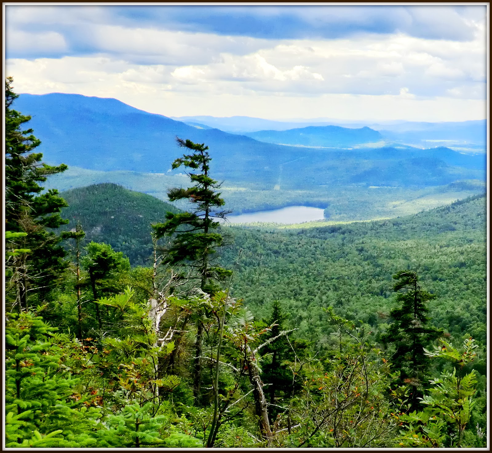
From ledges on the south side of the mountain,
there are expansive views. One of these
vistas is shown in the next photo. Rogers
Ledge and North Peak are in the foreground, and the Presidential Range is on
the horizon. South Pond is at the lower left of photo.
 |
| South Pond; Rogers Ledge/North Peak; Presidential Range |
Another vista that can be seen from the south
side of Bald Mountain is the huge lineup of peaks in the Mahoosuc Range. The next photo is a zoomed panorama showing just one slice of this colossal
vista.
 |
| Zoomed panorama of Mahoosuc Range, as viewed from Bald Mountains south ledges |
Shown below is a Google Earth image which might
provide some perspective regarding the two spots that I visited. The red arrow points to the ledge
on Long Mountain. Bald Mountain is located below and slightly to left of
the ledge.
 |
| Google Earth image showing locations of the two places visited on this trek |
To sum it
up, visiting Bald Mountain near Stark, NH is always a pleasure, especially
when there are so many opportunities to enhance the trek by visiting other nearby
locations in the Nash Stream State Forest.
///////////////////////////////////////////////////////////////////////////
///////////////////////////////////////////////////////////////////////////
ADDENDUM (added 02-Aug-2013):
Since posting this report, I've received some
very interesting comments that were posted to my Facebook page. For example, one respondent (John Higgins) stated that the
ledge on Long Mountain is the result of a slide that occurred in
1974. He indicated that he and his family
often hiked to this spot up until the mid 1980s. And he further added that "It was
much easier to get there back then as the valley had been clear-cut and skidder
roads went very near to the bottom of the slide!"
Also, I'm very thankful for a comment posted to
my Facebook page by Kim Nilsen (founder of the Cohos Trail) who stated that the
ledge actually has a name! Apparently
rock hounds sometimes venture to this spot in search of amethyst and topaz, and
they refer to this location as "Diamond Ledge".
Kim's comment prompted me to do an Internet
search, and was delighted when I found a reference to Diamond Ledge on page 205 of a book entitled "New Hampshire: Off the Beaten Path" (7th edition), by Barbara Radcliffe Rogers and Stillman Rogers (ISBN
978-0-7627-4054-3).
Chances are good that I'll be making a return visit to Diamond Ledge for further exploration and photos. And hopefully, this Blog report will encourage visits to this spot by photographers more skilled than I. It seems to me that Diamond Ledge offers the potential for some stunning images in the capable hands of a skilled professional.
Chances are good that I'll be making a return visit to Diamond Ledge for further exploration and photos. And hopefully, this Blog report will encourage visits to this spot by photographers more skilled than I. It seems to me that Diamond Ledge offers the potential for some stunning images in the capable hands of a skilled professional.
13 comments:
John,
I can see you doing battle with those conifers. Awesome antler find. Your write up was wonderful and oddly left me homesick for New England. First time in my travels to Hawaii, I've ever been made to feel homesick for the forests of New England.
Ann
Hi Ann,
Thanks for taking time from your terrific Hawaiian travels to read and respond to my Blog! Very much appreciated!
John
Terrific report, John! Isn't it great to spot an objective like that and then whack through forests thick and thin to visit it? That's a spectacular fern glade. It looks like that ledge is well-defended! You got some unique views from your precarious perch.
There are some interesting slides and what looks like a beaver pond in the valley behind the southern spur. Might take some doing to get in there.
Steve
Thanks Steve! Obviously, I totally agree with you about the joy of spotting an objective and then finding your way to it by bushwhacking through the forest. As a child, I couldn’t understand why you were instructed to never let your crayon stray beyond the lines of a coloring book. Guess this oddball notion carried over into my adult life. I relish the freedom to stray beyond the trails within the guidebooks! :-)
And yes, that valley (Roberts Brook Valley??) behind the southern spur of Long Mountain is very intriguing! The topo map I’m looking at shows a 4WD road going from Bell Hill Road up to the “mouth” of that valley. But from that point onward, guess you’d be on your own to wander where few have ever wandered! In addition to the beaver pond and slides that you mentioned, there might also be some awesome cascades where Roberts Brooks plunges down that steep headwall from Long Mountain Pond. Fun stuff to daydream about!
John
For anyone who might be following comments to this Blog report by e-mail, please be advised that an "Addendum" has been inserted at the end of my original posting.
Great report and photos John. You got some great, and unique views from that ledge. I just did the 2 NH100 Longs this past Wednesday. As I always do, I looked at Google Earth to see if I'd be near any ledges. I did not spot this but it would have been a trek from where I was. I did however see the slides Steve mentioned. I was planning on heading there but after a closer look on G.E. and topo, I decided approaching those from above would not be a good idea. So the most interesting thing I saw was Long Mountain Pond while visiting those 2 wooded summits. Here's a link to a photo of it if interested. Just copy and paste in browser.
https://picasaweb.google.com/lh/photo/S106_CNZGuWGDMKQmGzxSZFY_aBMAqfzLr_E3p5PahY?feat=directlink
But the woods in that area are beautiful. And the open fern glades such as the one in your photo are always a treat when bushwhacking.
Thanks for sharing. Looks like I'm not finished exploring in that area.
Joe
Thanks Joe!
Yes indeed, from your location last Wednesday (i.e. the NH100 Longs), it would have been quite a trek to visit the ledge that I explored on Long Mountain’s south spur. But that ledge will always be there, and I’m sure you’ll eventually pay it a visit.
I really appreciate the link you provided to the photo of Long Mountain Pond. I’ve never been there, and so that was a real treat to see it. Also, it’s really neat that you saw those slides that Steve mentioned in his comments. If you were able to get any photos of those, I’d be interested in receiving a link. You could post it here, or send me a PM at randonneur8 AT yahoo DOT com.
John
Actually John, I should have made it more clear that I spotted the slides on Google Earth. I did not end up checking them out as it did not look like a good idea from the top given the steepness.
Thanks for the follow-up Joe!
For whatever reason, I thought you might have found a spot during your travels where you got a peek at the slides from a distance.
John
John, all your posts are interesting and informative and picturesque but you've really outdone yourself with this one! The story and the pictures are absolutely astounding!
I love the fern forest. Did you know that we don't have a single species of fern that grows in Utah? The moose antler was an awesome find too. And I'm glad you were able to "hang on" while hanging out on that scary ledge!
I appreciated the google earth photo at the end—it really helped to be able to picture the terrain you explored on this trek.
Another fun read!
Hi Rita,
This was such a fun adventure, and it’s gratifying to read that you enjoyed reading about it and the seeing the photos. And thanks for letting me know that you found the Google Earth image to be of value. I was hopeful that it might add a little something to the report to help readers gains some perspective regarding the two places that I visited on this trek.
Also, thank you for adding that tidbit of information about the total lack of native ferns in the State of Utah. That is amazing!
John
That is a beautiful area! I haven't heard of the Bald Mtn you mentioned. Is it in the WMG? I used to go to Christine Lake as a kid and an old friend has a camp up in the area on a small pond we would fish on. Would love to check Bald Mtn out someday, but I'll pass on the Long Mtn whack. That certainly looks like a precarious ledge, not necessarily for sitting, or the faint of heart! Reminds me of the ledge on Percy Peaks. Sounds like you enjoyed yourself!!
You always post cool hikes!! Keeps me coming back to read more!!
Hiking Lady
Hiking Lady,
Thank you for letting me know that you enjoy reading about the hikes that I post to my Blog. It’s always good to get feedback, be it positive or negative!
The Bald Mountain that I went to is not in the WMG. However, as mentioned in my Blog, there is a bootleg trail that begins at the far western end of the Bald Mountain Notch Trail (about a tenth of a mile or so from the junction with the Rowells Link Trail). If you want more specific directions, please feel free to send me an e-mail: randonneur8 AT yahoo DOT com.
Thanks again for your comments!
John
Post a Comment