
While trying to come up with a plan for my next outdoor
adventure, I stumbled upon a scenario whereby I could combine a hike, a
bushwhack, and a mountain bike ride.
This trip would be a little over 7 miles (round-trip).
About 4 of those 7 round-trip miles would be done by mountain biking
on an old logging road. A little over 2 miles
would be spent doing an out-and-back hike on a segment of the Hancock Notch
Trail. Another mile or so would be an
out-and-back hike on a portion of a bootleg trail that heads toward a peak with
a huge cliff known as "The Captain".
And finally, about 0.2 mile (round-trip) would be spent bushwhacking
to a small pond on the south side of the Hancock Notch Trail.
Maybe the map shown below will be helpful in making some
sense out of the preceding paragraph. (CLICK TO ENLARGE)
 |
| Map showing my route of travel (CLICK TO ENLARGE) |
PART 1: Seeing
"The Captain"
When I came to the end of the 2 mile stretch of logging
road, I stashed my mountain bike in the woods.
I then continued on foot along a bootleg trail. I've previously travelled this faint pathway
and knew that it would provide a good view of The Captain, plus a nice view of
the Sandwich Range.
The huge cliff on the south side of The Captain is such a
fascinating place with a beauty that is rugged and awesome. It’s tucked away at the head of a ravine that
is south of Mt. Carrigain and east of the Hancocks. There are a few vantage points where it can
be seen from a distance. But to get an
up close view, the only vantage point known to me is from what I've dubbed as
"The Captain's Ravine". By
hiking a segment of the bootleg trail that leads into this ravine, you can get some
intimate views of The Captain.
Shown below is a photo taken of The Captain during my
12-July-2013 adventure.
 |
| The Captain! |
Perhaps it should be noted that Carrigain Pond is located
at the base of The Captain's north side, and therefore some refer to this 3,540
ft mountain as Carrigain Pond Peak.
However, most often this place is referred to as The Captain. And actually, that name has been in use for
nearly 150 years. On page 188 of the
first edition of “Forest and Crag” by
Laura and Guy Waterman, there is a short passage where it indicates that The
Captain was given its name by the Portland White Mountain Club in the mid
1870s.
 |
| Excerpt from "Forest and Crag" by Laura and Guy Waterman |
From a meadow along the bootleg trail leading to
"The Captain's Ravine" there is a pleasant view looking southward
toward peaks in the Sandwich Range, including notable peaks such
as Mt. Passaconaway, Mt. Whiteface, North Tripyramid.
 |
| Sandwich Range as viewed from a meadow on the bootleg trail mentioned above |
- - - - - - - - - - - - - - - - - - - - - - - - - - - - -
- - -
PART 2: Flirting
with the Hancock Notch Trail
Following my love fest with views of The Captain, and of
the Sandwich Range, I returned to the spot where I had stashed my mountain
bike. However, the bike would remain
there while I headed off on to the next phase of my adventure which was to
bushwhack to a pond located less than a tenth of a mile off the Hancock Notch
Trail.
One might legitimately ask why I chose to visit a pond
which doesn't even have a name! Well, my
primary objective for this portion of my trek was merely to get a feel for the
eastern end of the Hancock Notch Trail.
The only portion that I'd previously traveled was en route to the
Hancocks when I hiked the heavily-used 1.8 mile segment at the western
end of the trail. And so, the unnamed pond was merely used as
an arbitrary destination. As some might
agree, a destination can be whatever you personally want it to be. For example, it doesn't need to be at the top
of a mountain where a trail ends!
You might be curious as to how I reached the Hancock Notch Trail from
the spot where my bike was stashed. Near
the end of the old logging road, it crosses the Sawyer River on a bridge and
then continues for only a few hundred yards where the road terminates at what I
presume was once a log landing site.
From the backside of the log landing there is a faint pathway which is
only a few hundred yards in length, and it leads you to the Hancock Notch
Trail.
Upon stepping foot on the Hancock Notch Trail, I was
immediately favorably impressed! Since
this trail is lightly traveled, the footway is relatively smooth, rather than
being choppy with exposed roots and rocks, as is the case with high-traffic
trails that have become eroded.
Of course I can only speak about the approximate 1-mile
segment of trail that I traveled.
However, it was in great shape, and had just recently been
maintained. There was fresh evidence of
brushing and removal of downed trees from the trail.
Shown below are a couple of snapshots taken along the
Hancock Notch Trail.
 |
| Snapshots taken along Hancock Notch Trail |
Okay, that was the good news, the other news (which is
really old news) is that portions of the Hancock Notch Trail sustained
significant damage in August 2011 when Mother Nature threw a temper tantrum in
the form of Tropical Storm Irene. There
are some sections of the trail along the Sawyer River where there is still
evidence of washouts and erosion caused by this storm. The next photo shows an example of the
damage.
 |
| Example of Tropical Storm Irene damage to trail along the Sawyer River |
The next photo is basically the same as the one shown
above. However, it provides a closer
view of the area where the Hancock Notch Trail is located. The pink line and arrow shows the trail's
corridor.
 |
| Pink line and arrow shows Hancock Notch Trail's corridor (after Irene's damage) |
After a trekking for about a half hour, I arrived at a
likely spot to leave the Hancock Notch Trail to do the short bushwhack to the
unnamed pond, which clearly shows up on Google Earth (see next photo). CLICK TO ENLARGE.
 |
| Unnamed Pond as seen on Google Earth image (CLICK TO ENLARGE) |
This body of water is probably nothing more than a beaver pond,
and it covers only about an acre of ground. Nonetheless,
some of the backcountry ponds of this type have an innate beauty. And some, like this one, provide a window in
the forest for some interesting views of
mountain peaks.
The next photo
shows my first view of the unnamed pond as I approached it. The yellow-colored specks on the pond are water lilies in bloom.
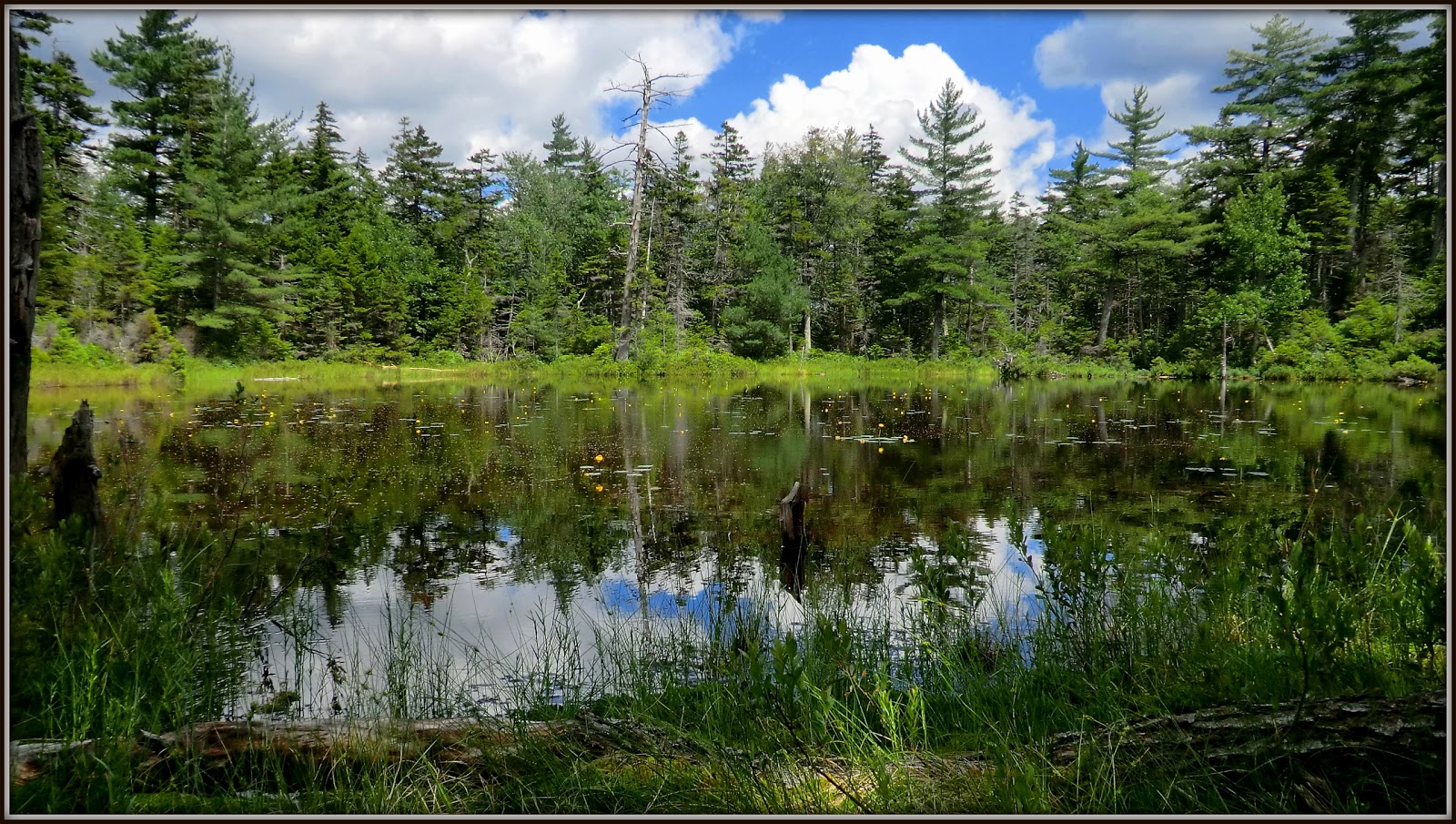 |
| First view of unnamed pond as I approached it |
As I walked around the pond, I could see ridges and peaks in the Hancocks.
 |
| Ridges and peaks in the Hancocks as viewed from unnamed pond |
 |
| View of Mt. Carrigain (nearly dead center, on the horizon) |
 |
| Left panel: view with binoculars. Right panel: enlargement of viewing platform |
To sum it up, this adventure lasted only about 4 hours. However, it was truly a fun experience. Not only did it include a trail and a destination that was new to me, but it also provided a varied experience of hiking, biking, and bushwhacking. And I can honestly say that it whet my appetite to travel and explore more of the Hancock Notch Trail.
6 comments:
That was a varied and imaginative exploration, John, and well-chronicled! I remember passing through that meadow many years ago en route to Carrigain Pond. I think it was more gravelly and less meadow-like back then. I wonder if the Forest Service is maintaining it as a "wildlife opening"? That little pond is a gem. I went there a couple times in the 90s after spotting it from South Hancock. There was an unusual view of "Juno peak" and South Hancock from somewhere along the edge. That area on the SE side of Hancock is pretty wild!
Steve
Thanks for your kind remarks, Steve.
With all the wet weather we’ve had, things were pretty soggy/boggy around the perimeter of the pond. Without sinking into the mire, I was unable to maneuver to a point where I could get a good photo of the Juno Peak/South Hancock combination. Please correct me if I’m wrong, but I think South Hancock is visible in my 3rd photo from the end??
Further regarding our wet weather, perhaps it might have caused the meadow to have become more meadow-like this year?? This was probably about the 3rd time I’ve visited this spot over the years, and like you, I seem to recall it being more barren than it is now.
John
I like the fact that you picked an unnamed pond as an arbitrary destination! And the pond is quite a beauty too.
This outing sounds like a fun, "multiple use" adventure. Is mountain biking popular on the old logging roads of New England?
I can tell by the intense greenery in your photos that you've had quite a bit of rain this summer. Hancock Notch Trail looks interesting—what is its total length?
I was surprised to see all the damage done by "Irene". That trail could use a good maintenance person... such as yourself!
Thanks for another interesting look at New Hampshire's forests, peaks and ponds, John!
Oh, and it's wonderful to know that hiking was in vogue 140 years ago!
Hi Rita,
As always, I appreciate the time you take to read and comment on my blog reports.
You asked about the popularity of mountain biking on old logging roads. It’s difficult for me to say with any authority as to how popular it is. I have the good fortune of being able to do most of my outdoor explorations during mid-week, rather than weekends. At mid-week, I rarely meet others who are mountain-biking on the logging roads. However, weekends might be an entirely different story! :-)
You also asked about the total length of the Hancock Notch Trail. It runs for a distance of 6.9 miles. And so, percentage-wise, this particular trek only involved about 16% of the trail. However, as mentioned in my report, I have hiked the 1.8 miles at the trail’s western end which is heavily used as part of the route to two popular peaks known as North and South Hancock. I’m hoping that perhaps my mini-adventure was enough to give me a sense for what the trail is like at its eastern end. Don’t know when I’ll get around to it, but I have some ideas for hiking additional segments of this trail, both from its eastern, and its western end.
And finally, yes, Tropical Storm Irene really did significant damage to many of the trails in the White Mountains. The trail maintenance crews have done a great job of doing what they could to repair the trails in the aftermath of this horrific weather event.
John
Very cool idea to combine everything into one hike. I suppose in the winter you could replace the biking with skiing and still have a trio of fun activities in one hike. New trail is also a fun thing!
Thanks Summerset!
Perhaps the concept for this trek was subconsciously inspired by the “bundling” that goes on with certain service providers whereby your TV, Internet, and phone service are all bundled into one package! :-)
And yes, your idea of replacing biking with XC-skiing certainly has merit. Actually, I have done a few “bundled” winter adventures by combining XC-skiing with snowshoeing (both on and off-trail) all on the same trip. As with my bike, I stash the XC-skis in the woods, and then head off on my snowshoes.
Thanks again for taking time to read my blog and post your comments.
John
Post a Comment