
The title of this report might conjure up the image of me
hanging off the side of a cliff on Vose Spur, or something of that nature. Most assuredly, that was not the case! Instead, I paid a visit to the massive talus
fields on the south side of Vose Spur, and hung out there for a while to enjoy the
views and take a few snapshots.
Circumstances were such on this particular day that my available
time for hiking was compressed. However, a visit to the talus fields on Vose
Spur seemed doable (barely), and so a decision was made to give it a try. I left
home at near 1 PM and was back home by 7 PM. This was
made possible by averaging about 3 mph on the lower end of Signal Ridge Trail
and on the Carrigain Notch Trail. Also,
living within a 40 minute drive of trailhead is very helpful!
For anyone who might be unfamiliar with these talus
fields, perhaps the photo shown below might be helpful. This image was taken a couple years ago
from Signal Ridge while en route to Mt.
Carrigain.
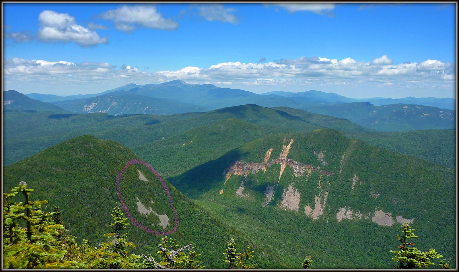 |
| Encircled on this photo are the talus fields on south side of Vose Spur |
The route that I used to the talus fields was different
from what I understand to be the traditional route used by most peakbaggers who
are intent on conquering the summit of Vose Spur. I think that particular route leaves from a
point not far from the boundary of the
Pemigewasset Wilderness and then heads up the east side of Vose Spur. However, I could be wrong about that. Regardless, I left the Carrigain Notch Trail
at about 1.3 miles, and then headed up a ridgeline on Vose Spur's south side.
A rough depiction of my bushwhack route is shown in the map below.
 |
| Rough depiction of my bushwhack route to talus fields on Vose Spur |
The climb to talus fields covered a distance of about
0.75 miles. It was generally a gradual
climb, but became moderately steep on the final approach. The forest was predominately hardwoods for the entire
distance. There were some obligatory
patches of hobble bush lower down. :-)
So what did I see once I arrived? The next 5 photos will hopefully provide some
general idea of the vistas that can be seen from this location.
If I'd taken the time to work at it, I probably could
have done a better job of composing a shot which more accurately portrayed the
vastness of the talus fields.
Nonetheless, the next photo will perhaps at least provide some idea,
even though it shows only a small corner of these massive piles of boulders.
 |
| One small corner of talus field on Vose Spur |
The next photo shows the main
view looking southward. In the center
are peaks such as Bartlett Haystack, Bear Mountain, Mt. Tremont, with pointy Mt.
Chocorua on the distant horizon. On the far right is Mt. Passaconaway.
 |
| Un-zoomed photo showing the main view looking southward |
The next photo is a zoomed shot which features peaks such as
Bartlett Haystack, Bear Mountain, Mt. Tremont, Owls Cliff, and pointy Mt.
Chocorua on the horizon on the right side.
 |
| Jumble of peaks surrounding Mt. Tremont, plus Mt. Chocorua is on far right |
The vista shown in the next photo is looking nearly due
south. Some of the prominent peaks are Mt.
Chocorua (at top on far left), and the backside of Green's Cliff (center,
right) with Mt. Passaconaway to the right of it (on the horizon).
 |
| Prominent peaks include Mt. Chocorua; backside of Green's Cliff ; Mt. Passaconaway |
Looking due west of the talus fields is the prominent
view of Signal Ridge leading to Mt. Carrigain.
 |
| View of Signal Ridge leading to Mt. Carrigain |
To sum it up, this was very enjoyable romp. The views were unique, and it was a fun
challenge to accomplish this hike within the time frame available to me.
6 comments:
Wow, great report and photos, John! Amazing that you were able to squeeze that in during your time frame. Love the way the view south is framed by the Carrigain Brook valley.
I take it you were on the lower, paired talus field shown in your photo from Carrigain. The upper one is the one Vose peakbaggers hit, I believe. Mike D. and I hit that one when we did Vose.
Talus fields like this and the ones on Zealand, Owl's Head (east side), West Bond and West Tecumseh are interesting in that there are no obvious cliffs above them. I'll have to ask Thom Davis how these develop in the midst of thickly wooded slopes.
Steve
Hi Steve,
Thank you for the compliments.
It was “risky business” trying to make this hike fit into my time frame. Actually, on the way out, I’d already resigned myself to being ‘in trouble’ for a late arrival at home. But, as often happen on the return leg, things can happen quicker than anticipated. Wouldn’t want to make a habit of doing things like this on such a tight schedule. The pressure is a twin-edged sword, i.e. exhilarating, and nerve-racking! The nerve-racking component removes a bit of joy from the adventure. :-)
Please shoot me an e-mail and/or post what you find out from Thom about talus fields that form in the midst of thickly wooded sloped with no obvious cliffs above them.
John
I'll have to second the kudos on accomplishing such an adventure in your time frame. I too have hit the higher talus when summiting Vose Spur. Beautiful photos. I love cloud shadows for some reason.
And I too would be interested in knowing how talus forms from no obvious source.
Thanks for sharing,
Joe
Thanks Joe! Not sure if I deserve praise or ridicule for this rather bizarre adventure! :-)
Probably would never have even considered doing this in such a compressed time frame if I was unfamiliar with the trails to be travelled. From previous experience, I knew it was possible to average about 3 mph on the trails I’d be travelling. Also, knew that generally can average about 1 mph when bushwhacking through hardwoods. This trek involved about 6 miles on-trail + about 1.5 miles off-trail. So, 6 miles on-trail @3mph = 2 hrs + 1.5 miles off-trail @1mph =1.5 hrs, which gives a total hiking time of 3.5 hrs. Adding 1.5 hrs for driving to/from trailhead gives a grand total of 5 hrs. Since I had 6 hours to play with, that left an extra hour for photos, unknowns, etc.
Admittedly, this was a very tight schedule which could have been ‘blown out of the water’ even if just one thing went slightly wrong! This type of “speed hiking” is unlikely to become my norm. But, I’m very happy that I did the hike, and even happier that things went as planned! :-)
John
From your first photo it looks like these talus fields are nearly vertical! This was definitely a case of speed hiking by my standards. But I can see why you attempted this hike on such a gorgeous day. The sky and the clouds are so perfect it looks like they could have been photo-shopped onto your pictures!
I've hiked on talus more than a few times and found that the footing can be very tricky. Luckily you didn't have any "slip-ups"—it could have added considerably to your time!
I enjoyed this read about another of your adventures, John!
Hi Rita,
Yes, regarding that first photo, “what you see, is what you get”! The talus fields on Vose Spur are indeed VERY vertical!
And yes, I know what you mean about the sky and the clouds being almost too “picture-perfect”. Even when viewing these scenes in-person, it appeared as if Mother Nature was doing a bit of ‘photoshop’ work right before my eyes!
And lastly, you’re so astute in guessing that the gorgeous day played a role in my decision to launch such an adventure on a very tight schedule. I felt compelled to at least give it a shot, especially since it might be several days before we see the sun again due to the rain that is forecasted for the upcoming days.
As always, thank you for taking time to read and comment on my Blog reports.
John
Post a Comment