
Nearly a month
ago when an appointment was made for 04-April, I predicted that this day would
be ideal for hiking. Yup, sure enough
it was! Oh well! The appointment was kept, but it left only a
few hours for hiking on a rare day filled with abundant sunshine.
I opted to spend
my precious few hours by doing a hike to Boy Mountain. This little mountain tops out at only 2,234
ft, but it provides some remarkable views from a ledge near the summit. The hike also provides a decent workout. Although the one-way distance is only 0.7
mile, there is an elevation gain of 650 ft over that short distance. It will definitely get your heart-rate up!
Boy Mountain has
appeared on some older maps as Ball Mountain.
Some feel that the name of this mountain is a corruption of the French
word for woods, i.e. "bois".
To access the
trailhead, I drove a slightly indirect route in order to enjoy the roadside
view of the Presidential Range at Jefferson Meadows on Rt. 115A, as well as the
vista
from Jefferson Highlands when driving east on Rt. 2 near the junction of Rt.
115. The next two snapshots show the
scene from each of the locations just mentioned.
 |
| Vista on Rt. 115A at Jefferson Meadows |
 |
| Vista from Jefferson Highlands when driving east on Rt. 2 near the junction of Rt. 115 |
There is no sign where the trail to Boy Mountain leaves Rt.
2, (1.1 mile east of the junction of Rt. 2 and Rt. 115). You need to park on the elevated grassy shoulder
of the south side of the highway (just west of Carter Cut Road). Cross the highway, walk a hundred feet or so
west along Rt. 2 and go up the first driveway on the north side of the road. As you pass between a house and a barn you
will see a trail sign attached to a small shed (see photo below).
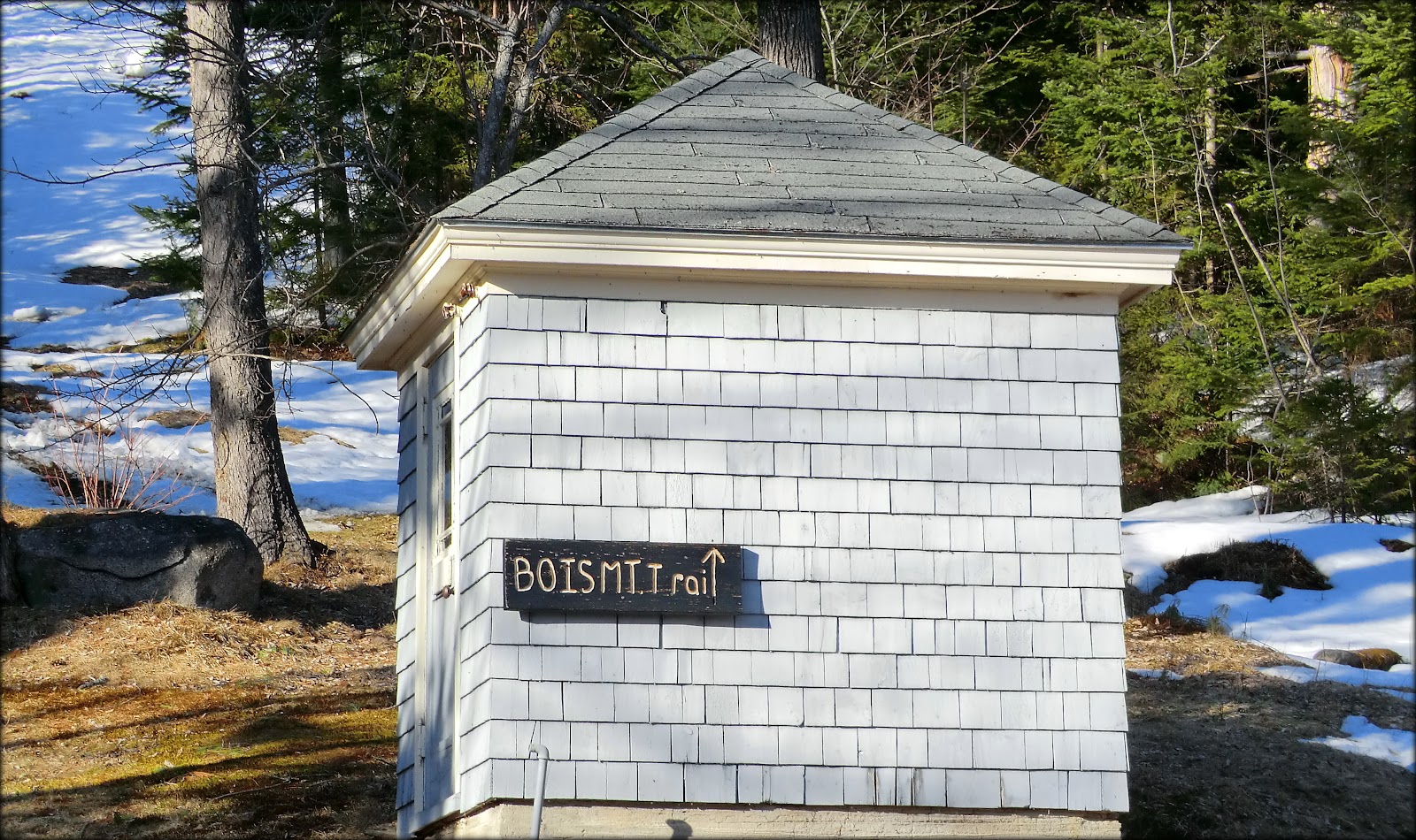 |
| Starting point for trail to Boy Mountain |
It's always a bit uncomfortable to walk up
a private driveway to access this trail. But apparently the Carter-Bridgman family who maintains this trail on their private land has no
problem with it.
Beyond the sign on the shed, you walk a few yards up a slope to the point where the trail enters the woods to the right and then begins to ascend. The trail isn't blazed, but is generally easy to follow. Abrupt changes of direction are marked with a wooden arrow attached to a tree. If there is no arrow, and you're unsure which way to go, chances are good that the proper course of action is to just continue straight ahead.
Beyond the sign on the shed, you walk a few yards up a slope to the point where the trail enters the woods to the right and then begins to ascend. The trail isn't blazed, but is generally easy to follow. Abrupt changes of direction are marked with a wooden arrow attached to a tree. If there is no arrow, and you're unsure which way to go, chances are good that the proper course of action is to just continue straight ahead.
As you approach the viewpoint near the top of the
mountain, there are (or were at the time of my hike) a series of pink flagging-tape
markers to lead you to the viewpoint (see photo below).
 |
| Flagging-tape markers on the final approach to the viewpoint |
I was surprised that the trail corridor was snow-covered (with
a depth of about 7+ inches) all the way from the trailhead to the viewpoint
near the top of the mountain. Since I
had not brought snowshoes, I was thankful that the snowpack was firm enough for
bare-booting without creating postholes.
The preceding photo, plus the next photo shows the snow conditions encountered during this hike.
 |
Representative
segment of trail corridor leading to Boy Mountain
|
Since the viewing ledge itself has direct exposure to the
sun, it had very little snow. The bare
rocks provided a choice of great places to sit and enjoy the view!
 |
| Viewing ledge on Boy Mountain |
Although there are other views from the ledge on Boy
Mountain, the star attraction is the vista of the Presidential Range
(next photo).
 |
| Presidential Range as viewed from Boy Mountain |
The next two photos are highly-zoomed images and are
representative of what can be seen with binoculars.
 |
| Zoomed image of the summit of Mt. Washington as viewed from Boy Mountain |
 |
| Zoomed image of Castle Ravine (left) and Mt. Jefferson (right) as viewed from Boy Mtn. |
It has been nearly 9 years since I last visited Boy
Mountain. At that visit, I don't recall
an opening (just a few hundred feet north of the viewing ledge) which provides
a view of the Pliny Range. I suspect
this opening was created by logging operations that have occurred since my last
visit. Regardless, the next photo shows
the view that I'm referring to.
 |
| View of Pliny Range from opening located just north of viewing ledge on Boy Mountain |
To sum it up, this short hike to Boy Mountain provided me with an
opportunity to enjoy the few hours that I had available for hiking on a
beautiful sunny day. I'm grateful to
live in an area where there is such a variety of hiking opportunities.
6 comments:
Great shots and a perfect day with bluebird skies! It is a great hike. I agree it feels weird walking through someone's yard. When we did it a couple of yrs ago a man was working outside at the time and helped us find the start of the trail. IIRC there was some type of old road you pass part way up as well as some bootleg trails, but no views of the pliny's. I have to admit it took me yrs to get the courage up to do that hike because it goes through someone's property. I agree it was a steep one! Thanks for posting this!
Hiking Lady
Hi Hiking Lady,
As always, your comments are appreciated, and they are right on the mark! It’s especially good to read that you are in agreement about Boy Mountain being a relatively steep hike.
It’s so uplifting that there are still people here in the North Country of NH who are willing to share their property with others, and who are genuinely friendly folks. Of course, I’m referring to the family who graciously allows hikers to access Boy Mountain via their property. I was reminded of this type of friendliness upon my return to Bethlehem from my recent trip down South. When I stopped by my local bank, two of the tellers immediately greeted me, welcomed me back home, and engaged in friendly conversation. Southern hospitality is nice, but small-town New England hospitality is magnificent!
Thanks for your compliments about my photos!
John
Beautiful pics, John! Haven't been up there in a long time, and forgot how good the view was. I agree that it's a bit uncomfortable starting up the driveway. But it's great that those folks are willing to provide access.
Steve
Steve . . . thank you for the compliment about the photos!
Like you, I also had forgotten what a nice view there is from this location. Let’s keep fingers crossed that the kind-hearted folks at the trailhead continue to allow access for many years to come!
John
I had never heard of Boy Mountain before—your post was a great introduction to this wonderful little hike. That is quite an elevation gain over such a short distance. We have one of those short-but-steep hikes near here and, in addition to being a lung-buster, it's also pretty hard on the knees!
Yes, it's so nice that some private property owners are gracious enough to allow hikers to travel through their property to access trailheads. Glad to hear that New England hospitality is alive and well!
April 4th was indeed a beautiful day for a hike. Thanks for sharing, John.
Thanks for your comments, Rita!
I drive by the trail to Boy Mountain many, many times on my way to other destinations. Although the property owners themselves never present a reason for discomfort in walking up their driveway to access the trail, it’s still uncomfortable to do this. This self-imposed discomfort is the main reason why it has been 9 years since I last did this hike. Perhaps now that I’ve ‘broken the ice’, I’ll make it a point to not let another 9 years pass before doing this hike once again! :-) Regardless, I (along with others in the hiking community) are grateful the landowner’s ‘New England hospitality’ by continuing to allow access to this marvelous little mountain.
John
Post a Comment