
The Benton Range is a collection of six low-elevation mountains,
none of which attain even a 3K status. These
mountains are: Jeffers Mountain (2,994 ft); Black Mountain (2,830 ft); the
Hogsback (2,810 ft); Blueberry Mountain (2,662 ft); Sugarloaf Mountain (2,609
ft); Owls Head (1,967 ft). Other than
Owls Head, I've visited all the mountains in this range. This involved some bushwhacking since Black
Mountain and Blueberry Mountain are the only two peaks in this range that have
maintained hiking trails.
The hike that is the subject of this report was launched
from the east terminus of the Blueberry Mountain Trail which is located on Long
Pond Road near the small settlement of Glencliff, NH. On several occasions I've hiked to Blueberry
Mountain via this approach route.
Therefore, this would not exactly
be a new hike for me, but it was "new" in the sense that it would be
the first time I've been on this trail since the logging operations have come
to an end at that location. I was
curious to see the impact of those operations on the trail corridor.
Although the trek to the top of Blueberry Mountain is
only 1.7 miles from the trailhead, in the winter months you need to tack on
about another 0.6 miles since Long Pond Road is closed to vehicular traffic
during the wintertime. There are several
option for parking during the winter months.
You can park at the point where Long Pond Road is gated, but this can be
a tricky proposition, and I personally would advise against doing so unless you
have a 4WD/AWD vehicle equipped with snow tires. The other two parking options are: a plowed
bump-out on the shoulder of High Street (adjacent to High Street Cemetery); or the
trailhead parking lot for the Glencliff Trail.
After walking the approximate 0.6 miles (mostly uphill)
along Long Pond Road, I came to the trailhead for the Blueberry Mountain Trail.

Trailhead Sign for
Blueberry Mountain Trail
Beginning at the trailhead, you hike along a logging
access road for a very short distance (only about 5 minutes), and then the
hiking trail splits off to the right.
The snapshot below shows this departure point.

Point where hiking
trail departs logging road
You will also note in the photo shown above that there is
only a light covering of snow on the hiking trail. As you might suspect, there is a more of a snow
cover as you gain elevation. However, on
the day of my hike, you really could have done this entire trek without
snowshoes. However, I wore them anyway
since they provided a more stable platform on an uneven surface. Plus, I kept thinking that as soon as I
stopped to remove them, then it wouldn't be long before I'd need them, which
would involve stopping again to put them back on!
The hiking trail weaves its way through the various
logging cuts, as shown in the Google Earth image presented below. Although the imagery date for this satellite
view is November 2011, I think it's a fair representation of what currently
exists.

Google Earth
imagery of logging cuts on either side of Blueberry Mountain Trail
As can be seen from the image shown above, there is a
wooded buffer between the hiking trail and the logging cuts. However, especially at this time of year when
the leaves are down, you can clearly see some of these cuts from the
trail. In an attempt to put a positive
spin on this, if you care to venture a short distance off-trail, these
clearings do provide some views, such as shown below in the next photo.

View of South Peak
area of Mt. Moosilauke from logging cut off the Blueberry Mtn Trail
But
of course the best views are from the ledges higher up on Blueberry Mountain. And
particularly nice is the vista of Mt. Moosilauke, as shown below.

Mt. Moosilauke as viewed from
ledges on Blueberry Mountain
And
shown below is a zoomed view of Mt. Moosilauke.

Zoomed view of Mt. Moosilauke
The
next series of photos show some other mountain vistas that can be seen from the
ledges on Blueberry Mountain's east side.
(NOTE: As always, I won't be offended in the least
if a reader corrects me on features that I've misidentified.)

Carr Mountain

Wachipauka Pond/Webster Slide
Mtn (foreground) + Mt Cube ledges (upper right horizon)
Zoomed photo of Wachipauka
Pond/Webster Slide Mtn
In
addition to visiting the ledges on the east side of Blueberry Mountain, I
continued for a short distance along the trail to the west side of the
mountain. Along the way there is a huge
cairn. Perhaps a reader can enlighten me
as to the reason for its large size. I
know for certain that it's NOT located at the summit of Blueberry
Mountain. The only thing I can figure is
that since the trail does begin to descend at this point, perhaps this cairn
marks the high point of the trail itself?

Large cairn located on Blueberry
Mtn Trail (perhaps it marks highest point of trail??)
Regardless
of the purpose of the large cairn, as I began descending the west side of
Blueberry Mountain, it wasn't long before I came to a spot where there was a
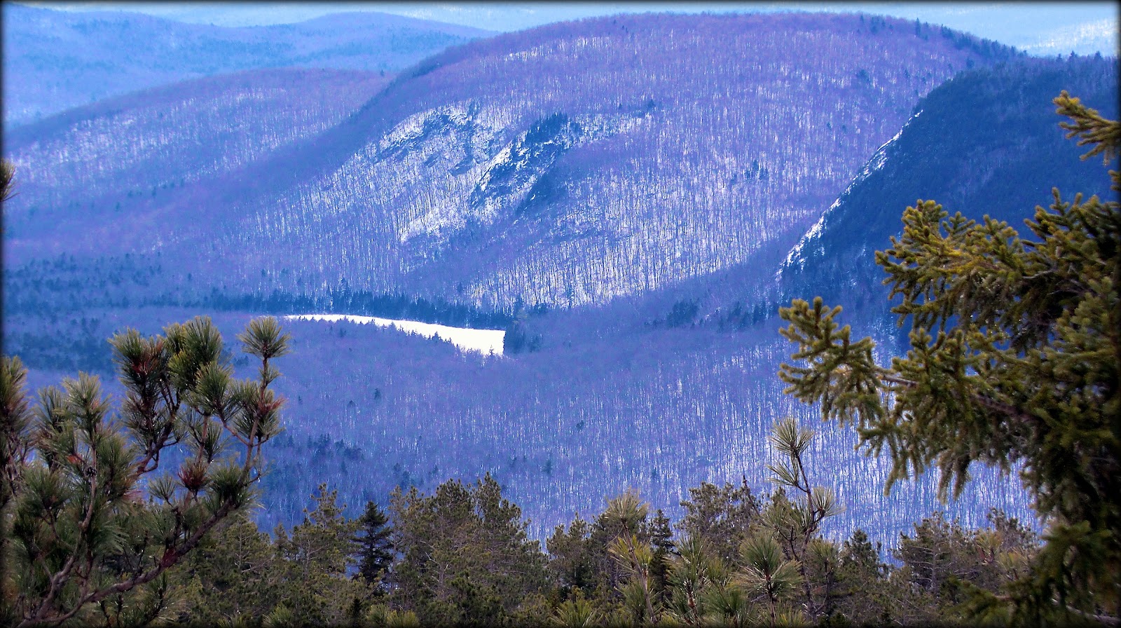
vista of three of the other peaks in the Benton Range. This vista is shown in the next photo. From left to right, you can see the ledges on
Sugarloaf Mountain, Black Mountain, plus a small sliver of the ledges on the
Hogsback (just below and slightly to the right of Black Mountain).

Sugarloaf Mtn; Black Mtn; the
Hogsback (as seen from ledges on west side of Blueberry Mtn
And
of course, what's a visit to Blueberry Mountain without a photo showing some of
the blueberry bushes! Shown below is
close-up snapshot of one of the countless number of blueberry bushes on this
mountaintop.

Close-up snapshot of blueberry
bushes on Blueberry Mountain
On
my way back down the mountain, I stopped to take a zoomed snapshot of the
Glencliff Home which was visible through the trees. This facility is nestled on the side of Mount Mooselauke.
Its goal is to provide a continuum of services for New Hampshire's
developmentally disabled, and/or mentally ill population in a home-like
atmosphere.

Glencliff Home as
viewed through the trees during descent from Blueberry Mountain
Then,
once I arrived back at the spot where I'd parked my car, I decided to walk a
few more steps to take a look at the High Street Cemetery which is listed on
the New Hampshire State Register of Historic Places. This cemetery is the last remaining resource that
conveys the history of the town’s early High Street area settlement, which was
bypassed by most industry and transportation. Stories of the pioneers who
settled this remote and rugged area are told by the cemetery’s 46 grave markers,
the oldest of which dates to 1812 and the newest to 1877.

To sum it up, even though this venture wasn't a
new hike for me, it was "new" in the sense that it provided the
opportunity to check out the east side of the Blueberry Mountain Trail
following the logging operations that have recently ended. Despite the logging cuts made on the side of
the mountain, I can say that Blueberry Mountain remains as a worthy
destination for a short hike at any season of the year.
12 comments:
Thank you John, maybe we will go there soon. And I will maybe do Black also.
Yvon, doing a combination of Blueberry Mountain + Black Mountain would provide a day filled with wonderful hiking! It is only about a 15 minute drive between the launch point for the Blueberry Mountain Trail (Long Pond Rd) and the trailhead for Black Mountain's Chippewa Trail (Lime Kiln Rd). I will look forward to reading a report of your adventure! :-)
John
Great report John. I did Blueberry Mtn for the first time last May. And pretty much the same way you did it. From the east passing over the summit to the west-side for more views. Other than that great ledge with the view of Moosilauke, I liked the views on the west side better. At any rate, which ever side you climb it from, it's worth passing over the summit to check out the other side. Great Photos.
What day did you do this? I came very close to doing this hike Monday and adding Jeffers & Hogsback to the mix.
Thanks for sharing,
Joe
Great photos and report, John! Love the photos of the Moose. Looks like the snow cover is pretty sparse over there.
Steve
Hi Joe! To answer your question, I did this hike on Monday (21-Jan), and so it sounds like we came very close to meeting each other. But then again, maybe not. By the time I finally decided where to hike and got on the road, it was about 11:30 AM before I arrived at the trailhead. You likely would’ve been there much earlier than me. Regardless, now that I see how sparse the snow is in the Benton Range, bushwhacking would be very easy in that region of the Whites . . . unless things change! :-)
Thanks for posting your comments, Joe!
John
Thanks Steve! I appreciate your kind words about the photos and report. And yes, the snow cover seems to be a bit meager in that area. I think one could do some significant off-trail travel without concern for easily tiring from wading through deep, unbroken snow! :-)
John
Thanks for this trip report, I know this one is on the 52 With-A-View list, and getting any info on these peaks is really nice. Pictures great as always, the one of the Glencliff Home is good because it gives an idea of where exactly you are in relation to the landmark. I'm guessing that particular photo is best taken at this time of year when the leaves are down. Now, if the temperature would come up out of the basement, it might be ok to venture outside and even hike!
Hi Summerset,
Glad you liked the report. You’re right about there being sort of a scarcity of reports concerning those peaks that are on the “52 With-a-View” list, especially as compared to the abundance of reports on the NH48 list.
And yes, you’re correct that the leafless seasons of the year are the prime time for taking images of the Glencliff Home from Blueberry Mountain.
Yup, the below zero temps + wind has put a temporary hold on any significant hiking, at least as far as I’m concerned. But, did you see that there is a possibility of RAIN in the forecast for next week! Yikes!
John
Hi John,
I'm pleased to see that the logging cuts haven't detracted appreciably from the scenery and views on this hike.
As for that large cairn, it could be that it's the high point on the trail. Or it could be that—as sometimes happens in the west—hikers have kept adding their own stones to the cairn to see how large and high they can build it before it topples!
Thanks for another nice report!
Hi Rita,
Your thoughts about my blog postings are always most appreciated!
Regarding that large cairn, I do know what you mean. There are some areas here in New England where hikers also add their “2 rocks worth” to a cairn. Something that immediately comes to mind is a cairn along a trail in VT where this is somewhat of a tradition. However, the cairn along the Blueberry Mountain Trail seems NOT to be one that falls into that category. It appears (to me at least) to be “purposely” constructed to be rather large, rather than haphazardly built by hikers adding rocks to it in a whimsical manner.
John
Hi, John!
Thanks for a great trip report. This is one of my favorite hikes in that area, and I had some concern about how the logging would affect the trail and views. Looks like it is still as beautiful as before. We will definitely plan to get out there this winter.
Thanks and happy hiking!
Kathy
Kathy, it was indeed reassuring to discover that the logging didn’t have a devastating impact on the Blueberry Mountain Trail.
Glad you liked the report, and thank you so much for taking time to post your comments. Very much appreciated!
John
Post a Comment