
My wife was unimpressed with the venue that I selected for the hike which I undertook on Valnetine's Day. Why could I not have included a destination in my itinerary with a romantic-sounding name such as Lovequist Loop, or Hart Ledge? Where was the romance in my decision to go to yet another spot in the White Mountains that is named Mud Pond?
There was only a roll of the eyes when I proffered that the trail leading to this particular Mud Pond is called the Tunnel Brook Trail. You know, "tunnel", as in "tunnel of love"! Ah well! I suppose I'll never be accused of being a hopeless romantic, perhaps just hopeless! :)
In the title of this report are the words "Missile to Grave". There is a reason for this!! I started my day with a visit to a missile, and finished the day with a visit to an old graveyard. The trek to Mud Pond is merely what I did in between!
As to why I began my day with a visit to an old Redstone missile, it just so happens that Warren, NH was on my route of travel to the trailhead for Mud Pond. I can safely say that Warren is the only New England village to have such an adornment on its town square. As to why the missile is here, please read the inscription included with the next photo. (And if you're really interested in learning more, then click HERE for more information.)

My day ended with a visit to an old graveyard in the tiny village of Glencliff, NH. (Shown below is a snapshot of the graveyard which was taken as the sun was setting.)

The majority of the headstones are unreadable since the inscriptions have succumbed to centuries of weathering. And I do mean centuries! On one of the headstones that was readable, the year 1813 is inscribed as the date of death. (Clicking on the image will enlarge it.)

As to why I ended my day with a visit to a graveyard, that is a bit complicated. I wanted to hike to Mud Pond by starting from the southern trailhead for the Tunnel Brook Trail. However, this trailhead isn't safely accessible due to the intense logging operations that are now in progress on Long Pond Road. So, to reach the Tunnel Brook Trail, I parked on a widened area on the shoulder of High Street, and from there I launched a short bushwhack through the Benton State Forest. The area where I parked is close to the old graveyard. Since I had some remaining daylight at the end of my trek, I decided to visit this spot.
Okay, now I'll finally describe the middle part of my day, which was the trek to Mud Pond. The short bushwhack (about 0.2 mile) at the start of my hike had an unexpected surprise. Just before crossing frozen Slide Brook to reach the Tunnel Brook Trail, I happened upon the ruins of what I presume to be an old sawmill (see photo grouping below).
[NOTE: Subsequent to posting this Blog, some well-founded speculation about this structure was received from a knowledgeable person in Gorham, NH. There is a strong possibility that this was an early 1900s electric-power plant. Please click HERE for a discussion about these ruins.]

Upon reaching the Tunnel Brook Trail, there was no evidence of human foot-traffic. This was no surprise, not only due to the logging operations, but also because this route isn't heavily travelled in the winter months anyway. The trail was in great shape with no major blowdowns. The snow depth was minimal and I was able to wear Microspikes for the entire trek.
For those who are unfamiliar with the location of Mud Pond, it is situated in a deep valley (the "tunnel") between Mt. Moosilauke and Mt. Clough. This area is sometimes referred to as Tunnel Brook Notch.
My previous treks to Mud Pond have all been launched from the northern trailhead, and they have all been done during summer months. And so, the southern approach route was new to me, as was the trek to this spot during the winter. As you might expect, the scene at Mud Pond during the winter is quite different from the summertime view. This stark contrast is shown in the next photo which compares a snapshot taken during this trek versus one taken during one of my summer hikes to Mud Pond.

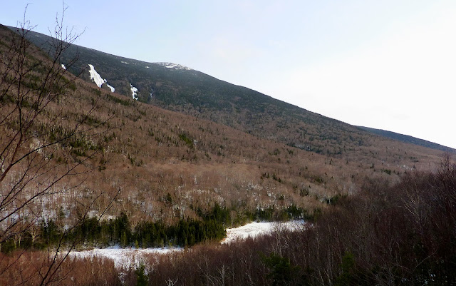
There is a chain of about 7 other smaller ponds just a short distance to the north of Mud Pond. These ponds are the result of beaver activity, and the collection is sometimes referred to as simply the Tunnel Brook Ponds. From many locations along these ponds, there is a view Mt. Moosilauke's South Peak (snow-capped peak seen in the next two photos).


Since there was so little snow in the area around the ponds, and since I had some extra time, I decided to go part way up one of the many slides on the east side of Mt. Clough. This provided me with a birds-eye view of a couple of the ponds, as well as another look at snow-capped South Peak (see photo below).
To sum it up, my "missile to grave" hike was another one of my rather curious adventures. Although it was fun for me, perhaps for others, not so much. :))
/////////////////////////////////////

There is a chain of about 7 other smaller ponds just a short distance to the north of Mud Pond. These ponds are the result of beaver activity, and the collection is sometimes referred to as simply the Tunnel Brook Ponds. From many locations along these ponds, there is a view Mt. Moosilauke's South Peak (snow-capped peak seen in the next two photos).


Since there was so little snow in the area around the ponds, and since I had some extra time, I decided to go part way up one of the many slides on the east side of Mt. Clough. This provided me with a birds-eye view of a couple of the ponds, as well as another look at snow-capped South Peak (see photo below).

To sum it up, my "missile to grave" hike was another one of my rather curious adventures. Although it was fun for me, perhaps for others, not so much. :))
/////////////////////////////////////
POSTSCRIPT NOTATION (Added 17-Mar-2012): It just came to my attention that in February 2012, the High Street Cemetery in Benton (photos above) was added to the New Hampshire State Register of Historic Places. This cemetery is the last remaining resource that conveys the history of the town’s early High Street area settlement, which was bypassed by most industry and transportation. Stories of the pioneers who settled this remote, rugged area are told by the cemetery’s 46 grave markers, the oldest of which dates to 1812 and the newest to 1877.
12 comments:
I have driven by that missile dozens of times, thanks for finally shining some light as to how it got there!
Very cool, John! There is logging on Tunnel Brook Road? That's a shame, it's such a beautiful area. I know the entrance from NH112 was closed in October because of damage from Irene...guessing it's still that way.
I've always loved the view of the scarred face of Clough from South Peak...nice to see the view from the scar.
Hi Grant,
I know EXACTLY what you mean! I also have driven by that missile on many occasions. Since I had some extra time, I decided to actually stop by the missile and take a photo of it PLUS read (and photograph)the informational piece that's posted nearby.
John
Hi Owen,
Glad you liked the posting!
By the way, I've since corrected it, but I made an error. The road where the logging is taking place is Long Pond Road. I incorrectly identified it as Tunnel Brook Road. Sorry for any confusion!
John
I always thought NH has a missile base or something but this clears it up. I never thought to actually get out of my car and read the sign!
Very cool post! As I drove to Moosilauke last week, I wondered about the Warren rocket. With a military background, the rocket was interesting to see here in NH. I wondered about that cemetary, too, thanks for sharing.
Hi John, I enjoyed reading this post - as always. However, not a single picture showed up on my screen, only a large black rectangle with a circle in the center; inside the circle was a white line, kind of like a horizontal "pause" button. Any idea what this could be?
Rita
Rita,
I first noticed this happening last evening. I deleted and reloaded all my photos into my Blog. Everything seemed OK when I checked things this morning. I've deleted and reloaded my photos once again. For now, things appear to be OK.
I have no clue what the problem is. Perhaps my album for this trek is corrupt and I'll need to recreate the album. In the meantime, I'm going to do some Internet research to see if others have experienced this problem, and if so what the solution might be.
Thanks for alerting me to this.
John
Hi John, I chuckled when I read the first paragraph as I thought that your blog post titles are so enticing and what follows in the post is always so interesting. Isn't mud pie a chocolate dessert? Maybe you could have brought one home for Valentine's Day! On another note, I too got the black squares with a white line when I first checked your blog, but of course now it is okay. Hope you are able to find the cause. Ellen
Hi Ellen,
Perhaps I need to have you become my “cupid advisor”!
Darn! I didn’t think of Mud Pie! That is indeed a chocolate dessert which would be “Valentine-appropriate”!
However, I tend to think that this analogy might have elicited the same roll-of-the-eyes, as did my “tunnel of love” idea. :)
Glad you enjoyed the Blog report. Sorry about the problem with the photos. Still don’t know what caused it. Hopefully, it will stay fixed!
John
Hi John ~ I've been red lining this winter, and when I read your post this morning I was thrilled!!! As of Monday, I had 4.9 miles left to cover in the Moosilauke section; approx .5 of the east end of the Blueberry Mtn trail (Steven & I hiked from the west end to just before the recent logging crossed the lower / eastern part of the trail last Saturday), and the length of the Tunnel Brook trail. I had pulled up to the gate about 2 weeks ago, and I noted the snowmobiling reference
- no snowmobiling Mon - Fri, snowmobiling allowed Saturday & Sunday - so I figured I could wander up the road to hike those trails some weekend. I was surprised to see the loggers working last Saturday, but due to the lack of snow, there probably isn't snowmobiling taking place there anyway. When I might look to hike the last remaining 4.9 miles was totally up in the air due to what I saw last Saturday. So this afternoon, I followed your brilliant idea, and bushwhacked from the old cemetery to the Tunnel Brook trail, and on the return trip, the loggers were done for the day, and I was able to wander-up-the-road and finish the last remaining segment of the Blueberry Mtn trail. Like you noted, the Tunnel is a gorgeous area indeed. A big thank you John! Cath Goodwin
And a big ”thank you” to you Cath for taking time to tell me that my post was helpful. That is very gratifying to know!
Congrats on completing your red lining in the Moosilauke section!
John
Post a Comment