
On 14-July-2011, I set off on an attempt to find evidence of the Stairs Brook Trail which had been abandoned in 1947 according to the 1948 edition of the White Mountain Guide (WMG). To assure that I got some reward for doing this trek, this adventure was designed as a loop hike to include Stairs Mountain. This would at least provide me with some views in case the "trail-finding" portion of my expedition was a complete failure!
Shown below is my route, which was about 12 miles round-trip.


Shown below is a side-by-side comparison of the two maps. The topo map is on top, and the WMG map is on the bottom. (Clicking on the image will make it slightly larger.)

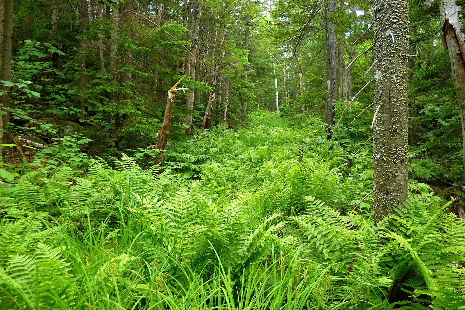
Not knowing for certain which side of the brook the old trail was actually located, I did some exploring along both sides. It was on the south side of the brook where I found the strongest evidence of a trail corridor. The photo shown below was taken from the south side of the brook. It shows a fern-laden corridor that is somewhat reminiscent of the old jeep road (a.k.a. Fire Warden Trail) leading to Mt. Hale. This similarity makes me wonder if perhaps the Stairs Brook Trail might have made use of a logging road, at least in part.
The next photo I thought was an interesting comparison. On the left is an area of hobble bush along the "possible corridor" for the Stairs Brook Trail, and on the right is an area of hobble bush along a short segment of the present-day Davis Path. Please understand that by showing this photo, I mean no disrespect to the Trail Maintainer for this portion of the Davis Path. I'm also a Trail Maintainer and I know how quickly hobble bush can take over a trail!

Also, I can say that Stairs Brook has some small, but nonetheless picturesque cascades such as the one shown in the snapshot below.

There have been numerous Trip Reports written about Stairs Mountain, and many of those reports contain photos more beautiful than I can ever hope to take. So, I'll just show two snapshots that I took during my visit.
The photo below shows the view as you approach the overlook at the end of the trail.


To sum it up, this was a fun adventure, at least from my perspective. It's completely understandable that others might find more pleasure in doing more conventional hikes.
12 comments:
Outstanding trip and report, John - I'm really sorry I missed this one! Interesting that this was called the Stairs Brook Trail, yet Upper and Lower Stairs Brooks are the next two brooks to the south!Perhaps this is Uppermost Stairs Brook?
Steve
Thanks Steve! As with so many of my trips, this was a last-minute impulsive decision to attempt this hike. I would loved to have had you along with me during this trek!
At many times during the hike, I was thinking of you, especially since I know that at one time you maintained a portion of the Davis Path. From previous conversations with you I know that you have done another trek similar to one that I've done by bushwhacking between the Davis Path and the Dry River Trail. And therefore, I wondered if you had also investigated the corridor for the old Stairs Brook Trail, as was reported here at this Blog.
Thanks again for taking a moment to post a comment.
John
White Mountain Trails was written by Winthrop Packard in 1917 and is accessible via the googlebooks website.
Chapter 16 is titled Up the Giant's Stairs. It describes the author trip from Jackson over the NE shoudler of Iron Mountain and than "up the back stairs". It is not clear to me whether he is referring to the route you explored or he actually went up south of you, but his trip ends at the col where your route ends.
Good luck.
Tom Murphy
PS I think the blog format better suits you as opposed to trail reports on VFTT.
Hi John,
Never been up that old Stairs Brook Trail corridor. I once did a late spring whack up the Upper Stairs Brook valley. Had hoped to follow the valley all the way up and approach the summit of the "Back Stair" from the col to the west, between it and Stairs Mountain. But there was still deep snow on the valley floor, so I ended up taking a direct route up to the Back Stair summit, and it was thick! There was a neat upthrust ledge at the summit with a great view. For descent I went directly down to Stairs Col Trail and luckily hit no impassable cliffs, as I had run out of water. It might be a more pleasant trip if you could follow the brook all the way up.
Steve
Tom, thank you for that terrific reference. I just finished doing an online read of Chapter 16. That is a truly fascinating story!
The following is pure speculation on my part. Even though the author mentions "Stairs Brook Valley" on page 243, I think he was likely referring to what is known today as "Lower Stairs Brook Valley", and located in that valley is the current-day Stairs Col Trail. Regarding his reference on page 244 to the "back stairs", I think this is probably a spot which today is referred to by the very same name by the rock-climbing community.
Thanks again Tom for taking a moment to post your comments!
John
Steve, thanks for your follow-up comment!
Well, even though you haven't visited the corridor where the old Stairs Brook Trail was located, it sounds like you had an amazing adventure while exploring the Upper Stairs Brook valley!!
John
Very nice John. Yesterday, I played around on the slides of Mt. Clough, retracing some of your footsteps from June and last year as well. Looks like I now need to add this hike to my list of things to do. I need to figure out how to move up north to cut the travel time to the trailheads. heh.
Congratulations John! That you found such a corridor (or segments thereof) so close to the mapped location of the Stairs Brook trail convinces me it's the real McKoy.
And why are some parts still so open, as shown in your great photo? Check out those ferns! As Steve Smith noted on his blog regarding his birch glade explorations some months back, these ferns (possibly hay scented?) and others are allelopathic, meaning they release chemicals which suppress the growth of other plant life.
Here's a good, short reference on how ski trail cutters use ferns to advantage:
http://www.treeskier.com/forestry/guidelines_allelopathy.html
Cheers, Cliff
Tobit,
Thanks for posting your comment, and most of all . . . congratulations to you for getting out there and exploring on what I alliteratively refer to as the "Cliffs of Clough"!
I'm assuming you crossed over the beaver dam that is nearly adjacent to the Tunnel Brook Trail, and then located the faint little herd path that sort of gets you started up the cliffs. Regardless, I'm sure there are any number of other access points.
John
Ah Cliff . . . thank you so much for posting the comment regarding allelopathy! At one point in the preparation of my Blog report, I even considered mentioning that botanical phenomenon. However, after all was said and done, I simply forgot to do so!
So, thanks again for a terrific reply, and also thank you for the link to the very interesting article.
John
John, negative on the beaver dam. We found a faint drainage further up the trail past the third pond and before Mud Pond. Followed this up to a really nice slide. I will definitely be going back in the fall when temps are a tad cooler. It looks like there are some nice stealth camping opportunities in the area as well.
John,
BTW, there are some pics of the slide I ascended on my blog... http://www.teamtobit.net/
- Tobit
Post a Comment