Pages

About Me

My photo
Bethlehem, New Hampshire, United States
E-mail contact: randonneur8@yahoo.com | Facebook: facebook.com/1HappyHikerNH

Text Above Search Box

SEARCH MY BLOG USING TEXT BOX SEEN BELOW:

25 June 2012

Mt. Willey: A Ladder Matter

The  "ladder matter" in the title of this report refers to the complex of ladders on the south end of the Willey Range Trail.  Anyone reader who has hiked this segment of trail is keenly aware of that which I speak! :-)

Those who follow my postings on Facebook have already seen photos of this trek to Mt. Willey via the ladders.  These same photos are presented here as a courtesy for followers of my Blog who choose not to participate in the Facebook experience, but who might have an interest in seeing the snapshots.

There's really not much of a story to go along with these photos.  It had been nearly 8 years since I'd clambered to the top of Mt. Willey (4,285 ft elevation) via the south end of the Willey Range Trail.  The afternoon of 24-June-2012 seemed like an opportune time for a reunion party to reacquaint myself with this route.

It was already beyond noon by the time I'd made the final decision about doing this hike.  However, I knew it was less than a 30-minute drive to the trailhead. Also, with the long days of June, there would be more than enough daylight hours to complete the mission.

The Willey Range Trail was accessed by hiking a combination of the Kedron Flume Trail and Ethan Pond Trail.  
The round-trip mileage for this trek was about 5.4 miles.  The elapsed time from the trailhead to the summit of Mt. Willey was about 2.25 hours.

The composite photo below shows the infamous "Willey Ladders".  Some of the photos in this collage were taken on the ascent, and some on the descent portion of the hike.
(As always, to enlarge a photo, simply click on it.) 
The "Willey Ladders"

The views from the top were as marvelous as ever.  The photos below show some of the vistas from this peak.
Looking Down Crawford Notch from Summit of Mt. Willey

Mt. Carrigain as Viewed from Mt. Willey

Crawford Cliffs and Presidential Range

Zoomed Photo of Mt. Washington and Surrounding Peaks

Mt. Willey's Summit Cairn

To sum it up, this was a very enjoyable adventure!  The views were wonderful, and climbing the ladder complex was an experience which was as invigorating as I had remembered it to be when I did it 8 years ago. 

23 June 2012

Hiking to Mt. Agassiz the Old-Fashioned Way


Back in the day before the automobile was commonplace, I assume that the folks in Bethlehem would merely step out the door and hike to the top of Mt. Agassiz.  Regardless of whether that was indeed the case, it is something that I occasionally do.  It's about a 5 mile round-trip jaunt from my doorstep to the top of the mountain.   As will be explained later, there is a more direct route available to the public which does not involve leaving from my doorstep. :-)

And so, the journey from my doorstep begins by walking into the woods at the edge of my property. 
(As always, click on any of the photos for enhanced viewing.)
Where my journey begins

A short walk on a pathway through the woods brings me to a rail corridor that once ran through the village of Bethlehem up until the early 1900s.
Old rail corridor

In certain places along the rail corridor, you can still spot some of the old wooden ties.
An old railroad tie

Most of the old rail corridor is wooded on either side, but there is one spot where you can gaze across an opening and see mountains in the Dalton Range.
Dalton Range viewed from old rail corridor

The old rail corridor eventually peters out, and then I head toward Main Street (US 302) where I emerge nearly opposite an eatery called Rosa Flamingos.  Once upon a time, at a spot just a few hundred feet from Rosa's, was the trailhead for Turner's Path which led to the top of Mt. Agassiz.  And actually, at one time this was one of four (4) trails from various locations in Bethlehem that would lead you to the top of this mountain!  In addition to Turner's Path, there was the Maplewood Path, the Strawberry Hill Path, and the Agassiz Carriage Road.
Rosa Flamingos (Turner's Path to Mt. Agassiz once left from a spot nearby)

My walk down Main Street takes me past a picturesque church which has been decommissioned and no longer in use.  It's for sale!  Anyone in the market for a church?
Church for sale

And as I continue down Main Street, I walk past a variety of businesses, such as those shown in the next two snapshots.
Antique store

 Auto repair shop

My amble down Main Street also takes me past a building that has been an eyesore for years.  Finally, the legal and financial obstacles have been overcome, and it will be demolished over the next several weeks.  The current plans are for the property to become the site of a new Public Library for the village of Bethlehem.

This building was built in 1876 as a hotel which was originally called the Avenue House, and later was named the Gramercy.  However, when it was last operational as a hotel it was known as the Maplehurst.  Before its demise it operated for a number of years as the Chase Golf and Tennis Camp.  When John Kennedy, Jr was 15 years old, he stayed at this camp for a month in the mid 1970s.

Here is a composite photo of this old building as it is readied for demolition. (This will eventually be the site of the new Bethlehem Public Library.)
Maplehurst Hotel as it appears in June 2012

And shown below is how this building appeared in its heyday.
Maplehurst Hotel in its heyday

Eventually, I leave Main Street and head up Agassiz Street (NH 142) which will take me to the entrance to the former Agassiz Carriage Road that leads to the top of Mt. Agassiz.

As I walk along Agassiz Street, I can catch glimpses of my destination.  In the next photo, Mt. Agassiz (with communication tower barely visible) can be seen on the horizon just to left of the house seen in the foreground.
Mt. Agassiz (with tower on top) on the horizon

The point at which I leave Agassiz Street (NH 142) is also the where the public can begin a hike to Mt. Agassiz by parking at a wide spot along the shoulder of the east side of road, exactly one-mile south of the junction of NH 142 and US 302 in the center of Bethlehem village. The next photo shows the "trailhead" parking on the shoulder of the road.
"Trailhead" parking for Mt. Agassiz

As you begin your trek, you might think you're at the wrong spot!  On the first 100 ft or so of the road to Mt. Agassiz there are some rusting abandoned cars, plus a couple of rundown buildings.  However, just keep walking and very soon you'll see the sign shown in the next photo. (If you don't soon see this sign, then you're on the wrong road!)
Sign near beginning of road to Mt. Agassiz

Most of the road leading to the top of Mt. Agassiz looks similar to what is shown in the next photo.
Typical section of roadway that you walk to top of Mt. Agassiz

Rather than hike the road, there is a path through the woods for the lower portion of the trek.  However, it's too complicated to explain as to how to access it, and besides you eventually need to emerge back onto the road for the final push to the top.
Path through the woods at lower end of route to Mt. Agassiz

On the way up to the mountain, there is a short side-path that leads to a spot where you can sort of get a preview of the vista available from the top of Mt. Agassiz.
View from short side path along route to top of Mt. Agassiz

When you get to the top of the mountain, the owner has kindly placed a sign which provides a brief history of Mt. Agassiz.
Sign providing a brief history of Mt. Agassiz

Besides the owner's generosity of allowing access to his property, plus providing an informational sign, he also maintains a gorgeous viewing area for hikers to enjoy, as seen in the next photo.
Viewing area at top of Mt. Agassiz

From this viewing area are several vistas including mountains in the Franconia Range and Twin Range.  A sampling of these views are seen in the next two (2) photos.
View toward Franconia Range

View toward Twin Range

While at the viewing area, I took a zoomed photo of the rocky summit of Mt. Lafayette (5,260 ft)  which I had just visited earlier in the week when hiking the Franconia Ridge. (Click HERE for a report of that hiking adventure.)
Zoomed photo of Mt. Lafayette from Mt. Agassiz

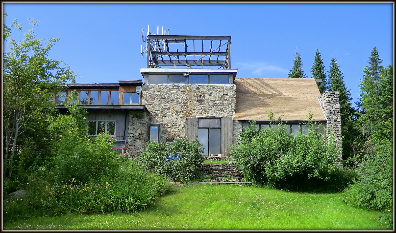
Directly behind the viewing area sits the owners house, as shown in the next photo.
Owner's house atop Mt. Agassiz

I didn't linger for very long at the viewing area.  The biting insects were out in force!  And so, I descended the mountain and returned home via the same route as was taken for the outbound leg of my journey.

To sum it up, it's terrific to be able to launch this trek from the convenience of my doorstep.  As indicated in the title of my report, perhaps this is the old-fashioned way of hiking to Mt. Agassiz, back in the days before automobiles were commonplace.  This is an enjoyable hike, and it also has enough distance and elevation gain to keep you in shape for ramblings farther from home.

19 June 2012

Franconia Ridge Loop: Nothing New, Just a Déjà Vu


Unlike many of my treks, this was nothing new, but rather just a "déjà vu hike" that I've done many times in the past.  Actually, this Franconia Ridge Loop hike has been done many times by many people.  Because of the remarkable views, it's a very popular hike.  And, as a result,  there are countless trip reports and blog postings about this trek.   Okay, so here's yet another one!

This is one hike that I don't mind repeating, but only on an occasional basis.  For it to remain special, I like to do it only sparingly.  For me,  a steady diet of the "extraordinary", makes it become merely "ordinary".  Well, that's enough philosophy, and so here is my report of the trek done on 18-June-2012.

For whatever reason, I prefer to do this loop in a counterclockwise fashion, which means ascending via the Falling Waters Trail and descending via the Old Bridle Path.  This route (as well as the clockwise route) takes you on a roller coaster ride of going up and down over peaks at the northern end of the Franconia Range, i.e. Little Haystack Mountain, Mt. Lincoln, and Mt. Lafayette. 

As the name implies, there is a lot of "falling water" on the Falling Waters Trail.  The photo collage below shows just a few of the watery scenes along the lower portion of this trail. (NOTE: To enlarge any photo, click on it.)

Upon reaching the top of the Franconia Ridge, I began taking the "touristy" photos that many readers have taken and seen many times over.

The first thing I did upon arrival at Little Haystack Mountain was remove my backpack and take a snapshot of Mts. Liberty and Flume, which reside at the Franconia Ridge's southern end (not where I was going today!).

Another photo I took upon arrival was the vista that includes Owl's Head (with the famous Owl's Head Slide in the center foreground), and the Bond range (peeking over the top of Owl's Head to the photo's left side).  Here in one photo are two destinations which are among the longest and most difficult hikes to New Hampshire's 48 highest peaks.

Just before descending Little Haystack, I met a Dartmouth College research team.  As I understand it, they are conducting an experiment designed to study the effects of wind-shielding on the interrelationship between diapensia and alpine bilberry.  Best wishes to the team for uncovering some interesting data!

Speaking of alpine-zone wildflowers, there were a lot of little "bouquets" tucked into nooks and crannies all along the route.

As I moved further northward along the ridgeline, I took several "ridge shots" such as the one that is shown below.

Along the way, I spotted two ravens who seemed to be enjoying the views.  Perhaps they were peak bagging.  They could probably do several peaks in one day since nothing would be very far apart "as the crow flies"! :-)

Somewhere between Mts. Lincoln and Lafayette, a bank of clouds began to move in and out, sort of like waves at the beach.  The next two photos show the clouds as they partially obscured Mt. Lafayette (1st photo), and Mt. Lincoln (2nd photo).


Once the "cloud wave" withdrew from Mt. Lafayette, I took a zoomed photo of hikers atop this mountain who were probably happy that the views had been re-opened.

When I made it to the top of Mt. Lafayette, there still was no cloud cover.  I was able to get the classic photo looking southward along the Franconia Ridge.

I also took a snapshot of the foundation for a structure which once stood there toward the end of the 19th century, as I understand it.

After summiting Mt. Lafayette and lingering there for awhile, it was time to begin the descent leg of the loop.  Once again, the usual snapshots were taken.

Here is the Greenleaf Hut as seen during the descent from Mt. Lafayette.

And, here is Eagle Lake as seen from the Greenleaf Hut.  As can be seen, clouds had once again moved in over the Franconia Ridge.

A trailside photo was taken of the Agony Ridge which would be my next destination on my descent.

And finally, from a viewpoint along the Agony Ridge, I took a snapshot which shows a major portion of the area that I had travelled earlier in the day.

With frequent stops for photo taking, it took me just under 6 hours to complete this loop of nearly 9 miles.  I started at noon, and was back at the trailhead just before 6 PM.  I had forgotten what bad-timing it is to arrive at this particular trailhead at that hour of the day.  There are mouth-watering aromas coming from folks at the Lafayette Campground preparing their evening meal over an open fire.   Being famished after 6 hours of hiking, it's so tempting to walk across the road and become an uninvited dinner guest!

To sum it up, as Yogi Berra is quoted as saying, this hike was like "déjà vu all over again".  Nonetheless, it was still a joy to re-experience the awesome views that this loop hike provides. 

16 June 2012

A Visit to Peyton Place (Camden, Maine)


The 1956 novel named "Peyton Place" was written by Grace Metalious. It is an exposé of the love-lives of the residents of a small New England  town where scandal and moral hypocrisy hide behind a tranquil façade in the years immediately preceding and following World War II.  The movie version was filmed primarily in the quintessential New England village of Camden, Maine.

I swear to you that the recent visit which my wife and I made to Camden had nothing  to do with scandal or moral hypocrisy!  It was all about sight-seeing and hiking in this lovely coastal region of Maine.

Much thought has been given as to how to best present our multi-day stay in the Camden area.  In the end, it was decided that it might be best to simply let the photos tell the story.  However, the downside to that approach is that nearly two-hundred photos were taken.  And so, I've decided to just present what I consider to be the "best of the best", and to categorize this handpicked selection of snapshots into six (6) groups as follows:

_ Downtown Camden and nearby shoreline
_ Views from Bald Rock Mountain, Camden Hills, ME
_ Rockland Breakwater, Rockland, ME
_ Mt. Battie and Mt. Megunticook, Camden Hills, ME
_ Views from Maiden Cliff, Camden Hills, ME
_ Beech Hill Preserve, Rockport, ME

(PLEASE NOTE: Clicking on photos will provide an enhanced view.)


Downtown Camden and nearby shoreline
Upon arrival, it was an overcast day, with rain threatening to happen almost at any moment.

Harbor in Downtown Camden:

Another Harbor Scene:

Camden Public Library Building:

Shoreline Near Camden, Maine:

Views from Bald Rock Mountain, Camden Hills, ME
Although it was overcast, a quick scamper was done up to Bald Rock Mountain located in the Camden Hills State Park where there are over 30 miles of hiking trails.  There were no blue-sky views, but the vistas overlooking Penobscot Bay were still very nice (see next 2 photos).


Rockland Breakwater, Rockland, ME (Click HERE for more details.)
On the second day of our visit, it rained all day.  Nonetheless, we still managed to do some sightseeing, including a short drive to the Rockland Breakwater.  We were not the only people trying to make the best of a damp situation.  Other folks were also out and about with their umbrellas.

Rockland Breakwater on a Rainy Day:

On the following day, we made a return visit to the Breakwater, and conditions were 100% better than the day before!

Rockland Breakwater on a Bright Sunny Day:

 Snorkeling for Star Fish at Edge of Rockland Breakwater:

 Star Fish Catch from Snorkeling at Rockland Breakwater:

Mt. Battie and Mt. Megunticook, Camden Hills, ME
From Mt. Battie, there are excellent views overlooking the village of Camden and Penobscot Bay.  And, it is a relatively easy hike to the neighboring Mt. Megunticook from Mt. Battie.  From the Ocean Outlook viewpoint on Mt. Megunticook, there are vistas overlooking Mt. Battie and the Auto Road leading up to it.  Plus, there are views of Camden and Penobscot Bay which are similar to those from Mt. Battie, only further away!

Camden Viewed from Mt. Battie:

Zoomed View of Camden from Mt. Battie:

Penobscot Bay from Mt. Battie:

View from Mt. Megunticook overlooking Mt. Battie, Camden, Penobscot Bay:

Views from Maiden Cliff, Camden Hills, ME
Maiden Cliff rises abruptly above Megunticook Lake.  On top of the cliff is a huge metal cross located near the spot where a 12-year old girl fell to her death way back in 1864.

Metal Cross Atop Maiden Cliff overlooking Lake Megunticook:

Lake Megunticook viewed from Maiden Cliff:

Beech Hill Preserve, Rockport, ME (Click HERE for more information.)
The final stop of our multi-day visit was at the Beech Hill Preserve.  At the top of this hill, there is a stone hut with a thatched roof.  It is known as "Beech Nut", and it was built in the winters of 1913 -1915 as a place for picnics and afternoon tea.  From this location, there are awesome views overlooking Rockport Harbor and Penobscot Bay.

Thatched Roof Building atop Beech Hill:


View from Beech Hill:

Another View from Beech Hill:

To sum it up,  our mini-vacation in the Camden area was terrific!  There is still much to explore in this picturesque area.  My strong suspicion is that we will make a return visit at some point!