Pages

About Me

My photo
Bethlehem, New Hampshire, United States
E-mail contact: randonneur8@yahoo.com | Facebook: facebook.com/1HappyHikerNH

Text Above Search Box

SEARCH MY BLOG USING TEXT BOX SEEN BELOW:

31 May 2011

C'est Fini! Martha's Mile on Cherry Mountain

It's unclear to me why the French phrase of "C'est fini" popped into my head upon finishing my trail-adopter work on the Martha's Mile trail located high upon Cherry Mountain.   Perhaps it's because subconsciously I know that it was the early French explorers who had originally named the current day Cherry Mountain as Pondicherry Mountain.  Or maybe my mind was making a "French-connection" with the upcoming Bruins vs. Canucks games at the Stanley Cup!

Regardless, I have adopted several trails in the Whites, and with the completion of the work on the Martha's Mile trail, my spring clean-up duties are finished.  I enjoy doing trail work and so my "C'est fini" is not said with a sense of relief, but more as a sense of accomplishment.  I'm already looking forward to starting the whole process again when putting all my trails to bed in the autumn and seeing how they fared over the summer months.

I try not to play favorites with my adopted trails, but I must say that Martha's Mile is my favorite!   To continue with the French theme, this trail has a certain "je ne sais quoi" quality about it which is appealing to me.  Perhaps it's because this trail has such a cozy feeling.  It's a narrow 0.8 mile long strip that runs along the forested ridgeline of Cherry Mountain and it serves to connect the peaks named Mt. Martha and Owl's Head.

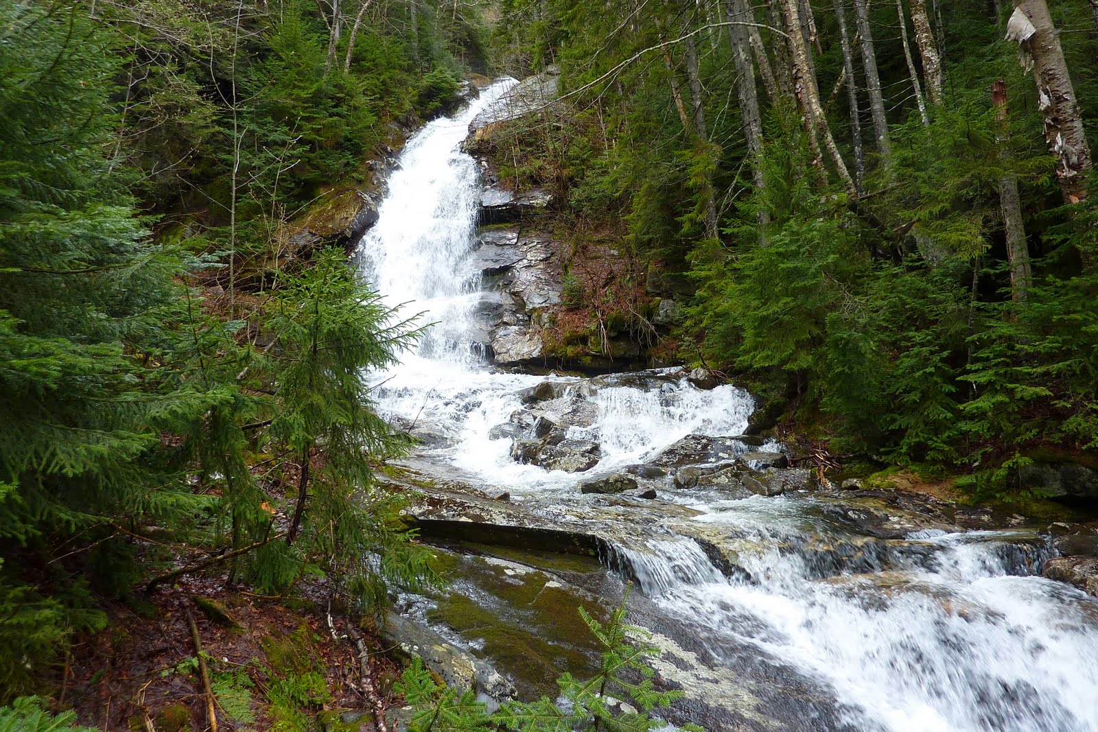
Shown below is a segment of the Martha's Mile Trail.
Besides the coziness of the trail, another source of appeal is that there are views at both end of this trail.  The Mt. Martha end of the trail offers views of the Presidential, Franconia, and Pilot mountain ranges.  But, for whatever reason, the view I find most pleasing is the vista of Crawford Notch with the pointy profile of Mt. Chocorua in the background (on the right-hand side). 
Once again, I'm playing favorites, but I prefer the Owl's Head peak over Mt. Martha.  For one thing, there are some very comfortable ledges at this location where one can sprawl out.  And the view toward the Presidential Range is outstanding (at least in my opinion).
From this location, you are close enough to make out many of the details of the Presidentials even with the naked-eye.  However with binoculars, or a zoom camera lens, even more detail is visible.
Also at Owl's Head, you are frequently entertained by turkey vultures that swoop and sway while riding the thermals in search of stuff (or just to have fun).  I wasn't disappointed on this trip.  The "big birds" put on quite a show!
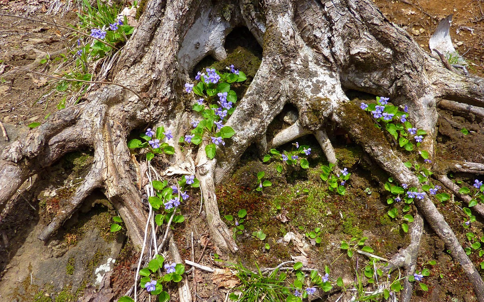
I'll just bore you with one more reason why I find Martha's Mile to be my favorite adopted trail.  I access Martha's Mile via the Cherry Mountain Trail.  In the spring, this access route has quite a number of wildflowers along the way.  We've all seen tons of wildflower photos, and so I've selected just one snapshot taken during my trek on 31-May-2011.  I'm no expert on wildflowers, but I think the one shown below is called the Foam Flower.
Oh!  Shown below is one more photo of a plant, but it's not a wildflower!  Someone can correct me if I'm wrong, but I think this colorful image is the immature pine cone of a Red Spruce tree. 
Besides the usual trail work activities (such as brushing, removal of downed trees, etc), the other thing accomplished on this work trip was to paint some additional blazes along the Martha's Mile corridor.  This will (hopefully) make for easier trail navigation during winter.  You might recall my Blog report from earlier this year where even I (the trail adopter!) had difficulty locating the trail during snow season! (Click HERE to view that report.)

To sum it up, my trail work for this spring season is completed.  Hopefully, the work done by trail adopters such as myself will serve to enhance the experience of the many folks who hike the trails within the White Mountain National Forest. 
--------------------------
Leaving a comment via this Blog is always appreciated. However, if you prefer to ask a question or make a comment via a personal E-mail, then you may contact me at: randonneur8@yahoo.com.

29 May 2011

Hiking Up a Hill, Painting Trees, Cutting Brush, Clearing Ditches . . . and Such

On 29-May, my friend Marty and I spent the day hiking up a hill, painting trees, cutting brush, clearing ditches, and such.   The "hill" we climbed was Mt. Tremont, and the "painting", "cutting", and "ditch-clearing" activities were all associated with my trail-adopter duties for maintenance of the 2.8 mile Mt. Tremont Trail.

It was great to have Marty's help, especially on this particular trip since there was a need to do some intense brushing on the upper 1.5 mile of trail, and also the need to do some blazing since several hikers had reported some difficulty with following the trail during winter travel.   With Marty doing a lion's share of the brushing, it made the dual tasks of blazing and brushing go so much faster.  

Also, it was very helpful having another set of hands to assist with removal of downed trees from the trail corridor.  There are still a few blowdowns that remain, but hikers should find these easy enough to duck under.  The trunks of these trees are quite large and require either a chainsaw for complete removal, or certainly a lot more time than we had available to hack away at them with an ax!  

Other than a snapshot taken of a blaze being painted, we didn't take time to photo-document our other trail-work.  We waited until we got to the top of Mt. Tremont to take most of our snapshots.  Well, let's say we took snapshots once the rain subsided and eventually stopped!  At the very moment we arrived at the summit, it started to rain.  It was just a bit comical that not a single drop of rain had fallen while we were clearing brush, painting blazes, etc.  But mind you, this was NOT a bad thing!   

The rain didn't last long, and besides, perhaps that was simply Mother Nature's way of cooling us down and washing away some of the sweat!  It's one way to look at it! :-)

I'll just bore you with a few snapshots taken during our Mt. Tremont trail work adventure.

The first photo shows Marty taking a well-deserved rest along the way.
The next snapshot is a collage of two photos taken by Marty.  One obviously shows a tree being blazed, and the other shows an umbrella being put to good use atop Mt. Tremont.
And lastly, shown below is a collage of two snapshots that I took from Mt. Tremont.  It was hazy after the rain shower, and ergo, the vistas that are shown of Carrigain Notch and of Sawyer Ponds are less than crisp!
On our way back home, we pulled into Fabyan's Station at Bretton Woods to pick up some items.  While there, we were entertained by a fox that was lurking about in the parking lot.  It did NOT appear to be sick or diseased.  My guess is that this sly fox simply had figured out that that a Bretton Woods location is a great place to panhandle for food!

Shown below is one of the fox-photos that I snapped.  In this particular shot, the fox has apparently become bored and is yawning while waiting for something to happen!
So there you have it!  Although this Blog report is filled with relatively few words, the day itself was filled with a lot of fun and accomplishment. 

Thanks again Marty for your help and your company!

-----------------
Leaving a comment via this Blog is always appreciated. However, if you prefer to ask a question or make a comment via a personal E-mail, then you may contact me at: randonneur8@yahoo.com.

21 May 2011

Watery Hikes along the Beaver Brook Trail and Other Locations

The best sentiment I could dredge-up relative to my recent hikes is the somewhat overused adage that says "if you can't beat 'em, join 'em". The weather here in northern NH (and most of New England) continues to be a bit on the damp and dreary side. So, it seems appropriate to just go with the flow (pun intended!) and do some weather-appropriate hikes.

On Saturday (21-May), my friend Marty and I decided to hike the first mile of the Beaver Brook Trail just so we could witness the spectacular display of cascades along that segment of trail. We had no intentions on this particular day of hiking the full length of the trail to the summit of Mt. Moosilauke.  Our destination was solely to the area along the trail known as the Beaver Brook Cascades.

We certainly were NOT disappointed with the venue we chose! It was quite an exhibition! Shown below are a few of the many falls we saw along the way.


Earlier in the day, Marty and I also visited Bridal Veil Falls. If you hike the Whites on a regular basis, then it's likely that you've visited this waterfall at one time or another.

Shown below is the scene at Bridal Veil on this particular day.
After the visit to Bridal Veil, we did a short bushwhack to Holden Falls. Click HERE for a link to a fascinating story (and photos) that was posted on the VFTT forum by NeoAkela in July 2010. His posting gives some history and describes his quest to rediscover these all but forgotten waterfalls.

I couldn't get enough of this waterfall, and so shown below are TWO views of Holden Falls. They are essentially the same view but with two different camera settings.

On 20-May (the day prior to the waterfall tour undertaken by Marty and me) I did a solo bushwhack along the east bank of the Saco River. I began from a point along the Davis Path and proceeded northward to Sleeper Brook. Upon reaching Sleeper Brook, I followed along its south bank for a few tenths of a mile before my available time ran out. And besides, the weather was beginning to deteriorate even more!

The yellow line on the map below provides an approximation of the route that I followed.
One thing of interest that I came upon during this trek was a patch of wildflowers that I've been unable to identify. They appear to be a mixture of a common blue and a white violet. Perhaps this wildflower is what's known as a "Dog Violet"??
Shown below are a couple of other snapshots taken during my Saco River/Sleeper Brook adventure.

Here is a scene along the Saco River.
And, here is a scene from along Sleeper Brook.

Oh! Please allow me to switch gears and return to 21-May, the day that Marty and I did our waterfall hikes. On our way back to Bethlehem, we decided to stop in the Franconia Notch to take a peek at the new "Old Man of the Mountain" exhibit that was just opened this month. Click HERE for a link to a newspaper article about this.

As you might have already read elsewhere, seven metal objects have been installed at the former Old Man viewing area. They resemble giant hockey-sticks and are dubbed as "Profilers". You get a general idea of what the Old Man looked like by standing behind any one of these Profilers and then looking toward the spot where the Old Man once was.

I must admit that I didn't take a lot of time trying to photograph what my eye was seeing, but I sort of think that to get a really good image you need to mount your camera on a tripod. Otherwise, (merely my opinion) I think you'll have limited success with getting a crisp image. Below is a rather fuzzy image of the Profilers, plus my feeble attempt at capturing an image of what I was seeing while sighting along one of the Profilers.

To sum it up . . . rain, rain . . . go away! Although rain is necessary, and waterfall hikes can be delightful, there is also something called "too much of a good thing"!
-----------------
Leaving a comment via this Blog is always appreciated. However, if you prefer to ask a question or make a comment via a personal E-mail, then you may contact me at: randonneur8 at yahoo dot com.

16 May 2011

Between the Rains: A Trek to Cherry Mountain

Throughout most of New England, and certainly here in northern New Hampshire, this third week of May has seen a lot of very wet weather! In between a rainy period I managed to work in a hike on 16-May to the peak named Mt. Martha which is located on Cherry Mountain.

From the outset, I knew there would be no views from the top of the mountain. En route to the trailhead, I stopped at a roadside pull-off along Route 115 to capture the image of the cloud-shrouded Pliny Range with Cherry Pond in the foreground. It was quite apparent that clouds were enveloping the tops of all the mountains in the vicinity of Cherry Mtn.
Since Cherry Mountain is less than a half-hour drive from my home in Bethlehem, I go there often. However, up until this hike, I had never climbed this mountain by starting at the trailhead on Cherry Mountain Road. One reason why I've never used this trailhead is that Mt. Martha is only 1.9 miles from the trailhead on Route 115, whereas it is 3.7 miles from the trailhead on Cherry Mountain Road. My route is highlighted on the map below (NOTE: Clicking on the map will slightly enlarge it.)
Shown below is the trailhead signboard on Cherry Mountain Rd. It is one of the new plastic signs that are now being used.
The treadway on this trail had mixed conditions. Some of it was dry, whereas other parts were wet and soggy. Shown below are snapshots of both types of conditions that were experienced.
At the higher elevations, there were lingering patches of snow both on the trail, and off the trail in the woods.
The trillium was in bloom, as shown below.
However, other flowering plants (like trout lily, spring beauty, hobble bush) were not in full blossom on the day of my hike.
Curiously, well off to the side of the trail, I saw two dead moose. One was a few tenths of a mile from the trailhead, and the other one was just a short distance from the junction high up on the ridge where the Cherry Mountain Trail comes in from the Route 115 trailhead.
At the top of Mt. Martha, I was in the cloud/mist, as I fully suspected I would be! There was nothing to be seen other than the footings for the old 40-ft fire tower that once stood at this location from about 1939 until the 1980s.
However, last year in 2010, I was at this same spot, except it was about one-week earlier. At that visit I had a terrific view as shown in the photo below that was taken last May.
There are a couple of other items that might be of some limited interest to a few readers. If you refer to the trail map shown at the top of this Blog, you'll see that the route is sort of "L" shaped. The abandoned Black Brook Trail once intersected the Cherry Mountain Trail at a point just a bit east from the sharp turn that forms the "L". It is not easy to spot, but if you look carefully you can still see a faint treadway (especially at this time of year). Also, a short distance back in the woods you can see what I presume to be the uprooted post that once held the signboard for the old trail. Below is a photo-collage which shows the post and the treadway of the abandoned Black Brook Trail.
I've never hiked the old Black Brook Trail at this upper terminus, but I have hiked a portion of it from its former trailhead which was located off Route 302 not far from the entrance to Zealand Road. Click HERE, if you have any interest in reading a Trip Report that I filed awhile ago regarding a hike from the lower end of the old Black Brook Trail.

There is one last item relative to Cherry Mountain that might be of some limited interest to a few readers. One of the ridgelines for this mountain has an area that is identified on many maps as "The Humps". It's nearly due east of Mt. Martha, and is shown on the map I posted at the top of this Blog. Click HERE, if you have any interest in reading a Trip Report that I filed awhile ago regarding a bushwhack that I did to "The Humps".

To sum it up, although there were no summit views on this particular day, it was still quite an enjoyable hike. Plus, it provided me with the opportunity to experience a trail that I'd never hiked.

--------------------
Leaving a comment via this Blog is always appreciated. However, if you prefer to ask a question or make a comment via a personal E-mail, then you may contact me at: randonneur8 at yahoo dot com.

12 May 2011

Preliminary Report: Loop Hike in Caribou-Speckled Mountain Wilderness

Within the next few days, a detailed report about this loop hike in the Caribou-Speckled Wilderness area will be available at my hiking partner's excellent Blog entitled "Mountain Wandering".  Steve does a much better job than I could ever do when it comes to presenting details about a hike such as this.  I'll add a direct link to his report once it appears on his Blog.
UPDATE (16-May-2011):  Steve's detailed Blog report is now available.  Click HERE for the link to it.

I'll just briefly state that three of us participated in this hike in the State of Maine on 12-May-2011: Steve, John G., and me (John C.). The on-trail portion of this loop was 10.3 miles. We did a couple of short off-trail forays which increased the total mileage by a few tenths of a mile. The trails involved in this loop were: Miles Notch Trail; Red Rock Trail; Great Brook Trail. Our route is highlighted on the map below. (NOTE: Clicking on the map will slightly enlarge it.)
The highlight of this hike, at least for me, was visiting the massive cliff just a bit east of the summit of Red Rock Mountain. Shown below is a snapshot of this cliff that was taken last autumn from a spot named Lord Hill.
Shown in the photo below is Steve on one of the ledges atop this massive Red Rock cliff.
And, the next snapshot shows a portion of the red-tinged cliff-face that can be seen by peering over the edge.
There are numerous very striking vistas to be seen from the cliff on Red Rock Mountain, and at several other lookouts along this loop. Shown below is just a small sampling.

A southwesterly view showing Kearsarge North and portions of the Moats, Chocorua, Passaconaway
A due south view showing Kezar Lake and Pleasant Mountain
A highly-zoomed view to the west showing Mt. Washington
And besides the distant vistas, there were many lovely things to see that were much closer. For example, there were numerous wildflowers in bloom. Shown below is a collage of several of the flowers that were seen.
The snapshot shown below is by far NOT the best photo ever taken of a turkey vulture! However, we enjoyed watching this guy perform aerial acrobatics as we sat atop the Red Rock cliff.
Toward the end of our loop, we stopped to take some snapshots of a picturesque cascade along Great Brook. Sunset was fast approaching and so the lighting wasn't the best.
And, shown below is just one final photo. It shows a couple of old porcelain trail signs that we encountered along our route. I'm certain that Steve will provide more details about these signs in his report.

To sum it up, please keep an eye out for Steve's report on his Blog. As indicated earlier, I'll update my Blog to include a direct link to his report once it's available.

--------------------
Leaving a comment via this Blog is always appreciated. However, if you prefer to ask a question or make a comment via a personal E-mail, then you may contact me at: randonneur8 at yahoo dot com.

08 May 2011

A Couple of Vermont Gems: Mt. Pisgah and Lake Willoughby

It's just a matter of mind-set, but each time I consider hiking across the New Hampshire border to either Vermont or Maine, the idea of long-distance travel pops into my head. And each time, I need to remind myself that the travel time and distance is often no further than many of the hiking locations that I visit within New Hampshire!

This past Sunday (08-May), I drove less than an hour from my home in New Hampshire to do a hike in Vermont. The specific location was the Mt. Pisgah/Lake Willoughby area which is located along Rt 5A near Westmore, VT, and it lies within a region known as the Northeast Kingdom.

There is an interesting bit of history associated with Lake Willoughby relative to the French & Indian War (1754-1763). In 1759, Robert Rogers led his Rangers on a successful raid of the Abenaki Indian settlement of St. Francis in Quebec, Canada. This raid was in retaliation for the Abenaki attack on a retreating British unit while under a flag of truce. After the raid, Rogers and his men were pursued through northern Vermont by French and Indian forces as they made their way back to base. As part of their escape route, the men hugged the rough and rocky eastern shoreline of Lake Willoughby.

Lake Willoughby is a glacial lake reaching a depth of over 300 ft. in places. Because of how it is dramatically situated between the steep cliffs of Mt. Pisgah and Mt. Hor, it has a close resemblance to a Norwegian fjord.

As you are approaching the Lake Willoughby area while driving north on Route 5A, the surrealistic image of Mt. Pisgah and Mt. Hor suddenly comes into view (photo below).
Before I started my hike up to Mt. Pisgah, I did a short little "hike-ette" to the south end of Lake Willoughby. It might just be me, but I think this lake has an awesome beauty!
Looking northward from south end of the lake

Eastern shore (Mt. Pisgah side of the lake)

Western shore (Mt. Hor side of the lake)
After my brief visit to the shoreline of Lake Willoughby, I began my hike to Mt. Pisgah via the South Trail.
Spring wildflowers were abundant all along this trail. Below is a collage of various flowers that were seen.
And shown below is a collection of violets that I thought was especially nice.
Like many trails, the South Trail has some wet & muddy spots here and there, but overall the treadway is in good shape. Large portions of the trail resemble what is shown in the snapshot below.
Throughout the entire course of my trek, I only hit one very small patch of snow which was located just a short distance from the summit of Mt. Pisgah.
As you ascend Mt. Pisgah, there are many tantalizing views of Lake Willoughby as seen through the trees off to your left. There is one spot along the way known as Pulpit Rock where you can very gingerly step out onto a very small perch to get a view that's unobstructed by trees (photo below).
Much better views of the lake and the surrounding area await you from viewpoints that are located just beyond the summit of Mt. Pisgah. However, you need to appreciate that all the above views are from ledges located on the steep rocky cliffs of Mt. Pisgah. The photo shown BELOW doesn't do complete justice to the rather precarious drop-offs at each of the viewpoint locations.
Although the drop-offs at these viewpoints might prove a bit unsettling to some folks, they do provide dramatic vistas as shown in the photos below.

Mt. Hor (the peak seen above and to the left of the cliffs)

Jay Peak (the peak with snow-covered ski slopes in the distance on the horizon)
Wheeler Mtn (flat-topped mountain with huge cliff-face at top left of screen)
Way off in the distance from these ledgy viewpoints (particularly the North Outlook), you can see peaks in the Franconia Range, the Kinsmans and Mt. Moosilauke across the border in New Hampshire.  Below is an extreme zoom-shot showing Cannon Mtn, the Cannon Balls, and Kinsmans.
In addition to the viewpoints on the lake side of Mt. Pisgah, there is another fantastic viewpoint on the other side of the mountain just a few hundred yards from Mt. Pisgah's summit. This vista provides a broad view down the West Branch of the Pamsumpsic River Valley. Burke Mountain dominates the landscape and is easily recognizable by its many ski slopes. Some photos taken from this ledge are shown below.

Barely visible on the hazy horizon to the right of Burke Mtn are peaks in the Franconia Range and the Kinsmans over in NH.
And, barely visible on the hazy horizon to the left of Burke Mtn are peaks in the Presidential Range in NH.
If you ascend and descend Mt. Pisgah (2,751 ft) via the South Trail, as I did, then a hike to the top of the mountain (plus a visit to the various overlooks beyond the summit) involves a round-trip journey of about 4 miles. There is a modest elevation gain of about 1450 ft.

Besides the area around Lake Willoughby, there are numerous other excellent hiking opportunities in the Northeast Kingdom of Vermont. The NorthWoods Stewardship Center (in partnership with the Green Mountain Club of VT) has produced an outstanding book in 2010 entitled "Northeast Kingdom Mountain Trail Guide" by Luke O'Brien. Over the upcoming months, I hope to check out some other hiking destinations just across the border in the very nearby State of Vermont!

-------------------
P.S.  On 10-July-2011, I did a follow-up hike to the opposite side of Lake Willoughby and visited several outlooks in the general vicinity of Mt. Hor.  Please click HERE to read my Blog report for that hike.