BOTTOM LINE: Hiked to summit of Mt. Crawford, and then
continued eastward for a few tenths of a mile beyond the summit to do two short
bushwhacks off the Davis Path. One foray
was to a cliff dubbed by Steve Smith as "Razor's Edge", and the other
was to the south slope of Crawford Dome.
DETAILS:
In early spring, it's often challenging for me to come up
with suitable options for outdoor adventures.
Although there is still a ground cover of snow, the warmer weather
generally makes the snow unsuitable for any enjoyable cross-country
skiing. Snowshoeing is still an option,
but the sun-softened snow can cling and clump, thus making each step seem like
lifting leg weights. And then as spring
progresses, the snow melt can raise water levels and cause issues with brook
crossings.
As dismal and foreboding as the foregoing paragraph might sound, there are still some outdoor adventures in the early days of spring that can be enjoyed with some
thoughtful planning.
My decision to hike to Mt. Crawford was based upon the
knowledge that the trail (Davis Path) is generally
well-travelled and therefore would likely require little if any
trail-breaking. Also, the brook
crossings on this trail are rarely problematic at any time of year. And lastly, since the overnight temperature
was below freezing, I figured that the snowpack should remain relatively firm
and non-clinging, at least until mid-day when the temperature was expected to
rise into the low 40s.
In planning this trek, I had thoughts of possibly extending the hike
by continuing eastward beyond Mt. Crawford to visit Mt. Resolution. However, on the morning of the hike, I
received an e-mail from Steve Smith reminding me of yet another possibility
which was to bushwhack to a cliff that he had dubbed as "Razor's
Edge". Although I'd never been
there, I knew where to find it from the description in his November 2012 blog. Steve's suggestion also prompted me to consider including yet another bushwhack to a nearby spot known as Crawford
Dome. I'd been there before, but never during wintry conditions (Click HERE for report of my previous trek to Crawford Dome.)
There were no real issues with the hike to Mt. Crawford
other than some annoying postholes created by someone who apparently decided to hike the trail without snowshoes. Some of the postholes were incredibly deep! It had to have been a very uncomfortable hike.
Following my hike to the summit of Mt. Crawford,
conditions were such that I opted to continue eastward along the Davis Path and
do the short bushwhack to Razor's Edge.
The snowpack was relatively firm, and the cliff was found with no
problem. It was an enjoyable mini-adventure
which provided unique views of the Razor Brook Valley.
Since the snowpack was relatively firm for the trek to
Razor's Edge, I then decided to continue onward and do a bushwhack to the cliffs at the northwestern end of Crawford Dome. Well, that didn't work
out nearly as well!
Not only had the air temperature risen, but also the
approach to Crawford Dome is predominately south facing. These factors resulted in a very soft
snowpack. Once I began sinking
thigh-deep on a frequent basis, I knew it was time to call it quits (or fold
'em, as I like to say). But before
giving up, I did manage to make it to a ledge which provided some very pleasant
views. And, much to my surprise, there
was one segment of the ledge that was completely free of snow!
PHOTOS:
Shown below are some snapshots taken during this
adventure.
 |
| Approaching the first open ledges en route to summit of Mt. Crawford |
 |
| Snapshot taken on final approach to summit of Mt. Crawford (looking northeasterly toward Stairs Mtn and southern Presidential Range) |
 |
| Looking northward up the Crawford Notch from summit of Mt. Crawford |
 |
| A vista similar to preceding photo, but looking a bit more westerly |
 |
| Southward view from summit of Mt. Crawford looking toward Mt. Chocorua and peaks in Sandwich Range |
 |
| Extreme zoom of Stairs Mtn with peaks in the Carter-Wildcat Range peaking through the gap between Stairs Mtn and Mt. Resolution |
 |
| Looking southward down Razor Brook Valley from the cliff dubbed by Steve Smith as "Razor's Edge". (Several decades ago, the Razor Brook Trail traversed this valley and connected with the Davis Path.) |
 |
| A vista similar to preceding photo, but looking a bit more westerly |
 |
| Extreme zoom of Mt. Chocorua |
 |
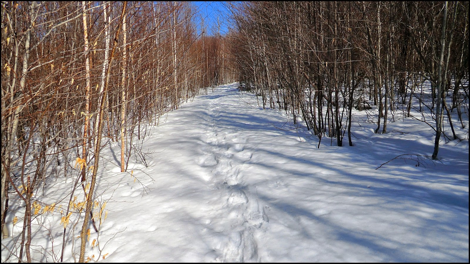
| The snowpack was fairly firm for the bushwhack to "Razor's Edge" cliff. (However, snowpack had softened considerably by time I started next bushwhack to Crawford Dome.) |
 |
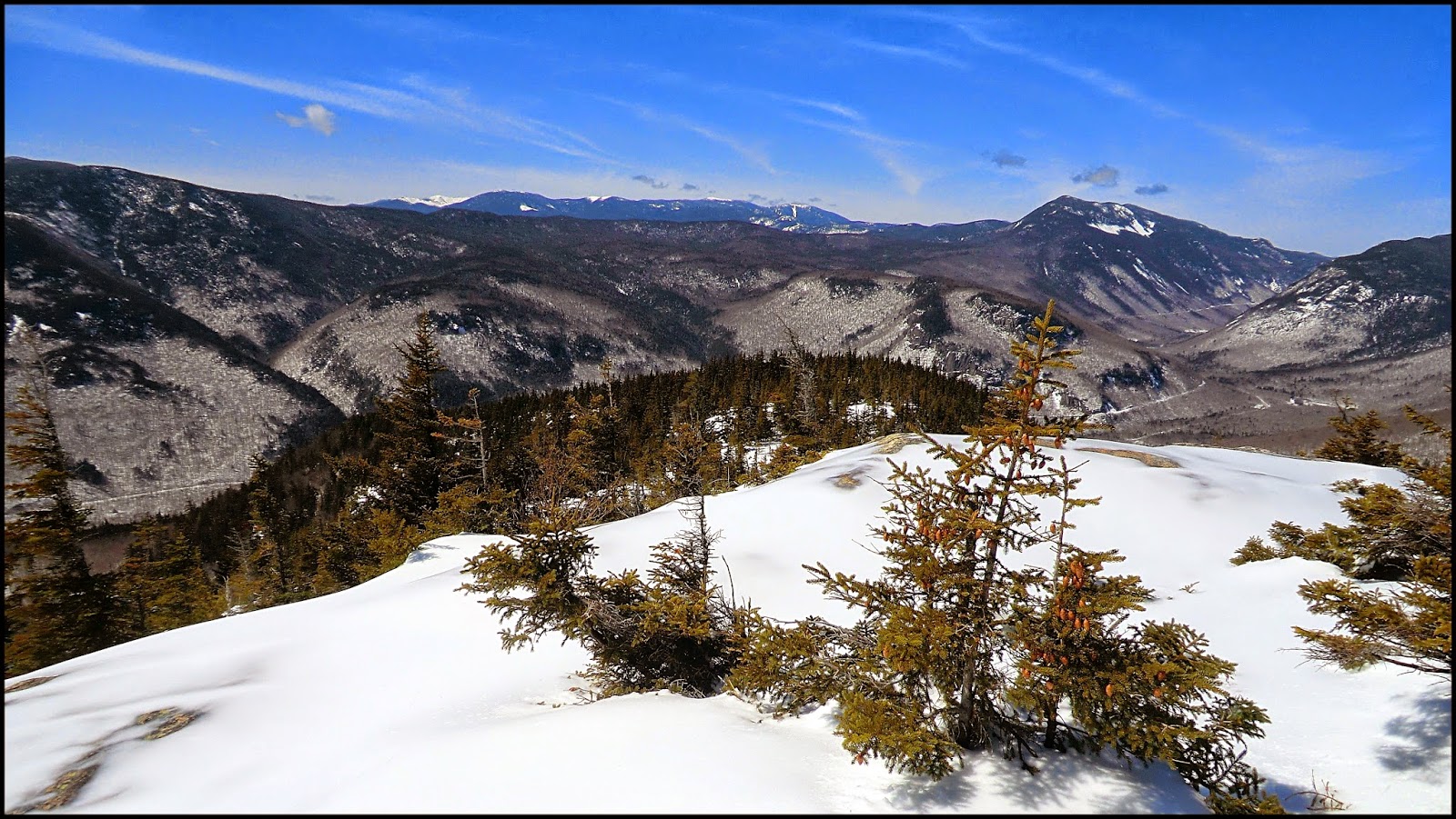
| Snowpack became too soft to comfortably continue all the way to Crawford Dome, but at least managed to get part way and had pleasant views of Mt. Resolution, Stairs Mtn, and 'peeks of peaks' in Presidential Range. |
 |
| As they say in real estate, "location, location, location"! Much to my surprise, there was one segment of this south facing ledge that had huge expanses of snow-free rock. |
 |
| This snapshot was taken on my descent from Crawford Dome. It's being shown merely because I thought it was one of the most attractive vistas I've seen that includes the Attitash alpine ski slopes. |
 |
| For those interested in the locations of my three destinations, each spot is marked with a red "X" on the map (click/tap to enlarge) |
~ THE END ~