Pages

About Me

My photo
Bethlehem, New Hampshire, United States
E-mail contact: randonneur8@yahoo.com | Facebook: facebook.com/1HappyHikerNH

Text Above Search Box

SEARCH MY BLOG USING TEXT BOX SEEN BELOW:

30 October 2013

3 Hikes in Western Maine: Albany Mtn; Round Mtn; Browns Ledge

On a sunny day in late October, I did 3 hikes south of Bethel, ME.  Albany Mountain and Round Mountain were both done as on-trail hikes, whereas the trek to Browns Ledge was a bushwhack.   As can be seen on the map presented below, all three destinations are in the same general vicinity and are just a short distance from each other.
Map showing locations of three hikes south of Bethel, ME (click to enlarge)
1) Albany Mountain

This hike began at the north trailhead near the Crocker Pond Campground.  The trail is now officially known as the Albany Mountain Trail.  However, until signage at the trailhead sign can be replaced, the sign still reads "Albany Notch Trail".  The trail was renamed when  large segments of the Albany Notch Trail were abandoned due to extensive flooding caused by beaver activity.
Albany Notch Trail sign will eventually be replaced to read "Albany Mountain Trail"
This trail is one of the best maintained trails that I've hiked.  Water bars are in great shape, the trail is well-blazed, and the corridor is very well brushed out.  Not much more you could ask for!

And to top things off, there is now a defined pathway with a complete line of cairns that lead you about 0.2 mile southwest of the summit to a spot described in the White Mountain Guide as "the best viewpoint on the mountain".  Previously, this route was sketchy and required some light bushwhacking.  This defined pathway is beneficial not only to hikers, but also to the thin soil and fragile flora on the ledges since it does away with multiple herd paths leading to this viewpoint.

The ledges on Albany Mountain afford panoramic views which I think would be very dramatic during the peak of colorful Autumn foliage.  However, this hike was done during a time of year known as "stick season" when the leaves are off the trees and the forest is generally drab.

The photos shown below are just two of my personal favorites from this hike.  Rest assured that in addition to these views, Albany Mountain provides many other fine vistas of mountains, ponds, ledges.
Lakes in vicinity of Stoneham, ME.  Keewaydin Lake is prominent, just left of center
A small slice of snow-covered Mt. Washington viewed over a ridge of Speckled Mountain
If you extend your trek to include the approximate 0.2 mile pathway to the ledges located southwest of the summit,  the round-trip hike to Albany Mountain is a little over 4 miles. 

2) Round Mountain

Round Mountain was a delightful surprise!  For whatever reason, the Maine Mountain Guide (10th edition) doesn't include this hike.  However, it is described on the Maine Trail Finder website (click HERE).

There is a sign posted at the trailhead which you can see once you pull into the parking area.
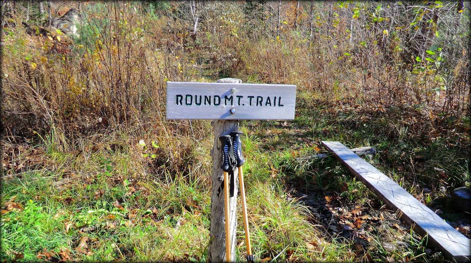
Sign at trailhead for Round Mountain Trail
Just a few steps beyond the trailhead is a sign-in logbook, as well as a nice map which is shown below.  The yellow diamonds represent the various viewpoints along the route.
Trail map posted near trailhead (yellow diamonds represent viewpoints)
The trail is very well maintained.  Although it is unblazed, it is exceptionally well-marked with cairns all along the route.  The next photo shows one of the more elaborate cairns.
One of the many cairns all along the corridor of the Round Mountain Trail
Soon after leaving the trailhead, you enter a predominately hardwood forest with many Red Oak trees.  Some of them are gnarled, broken, and hollow, but still living.
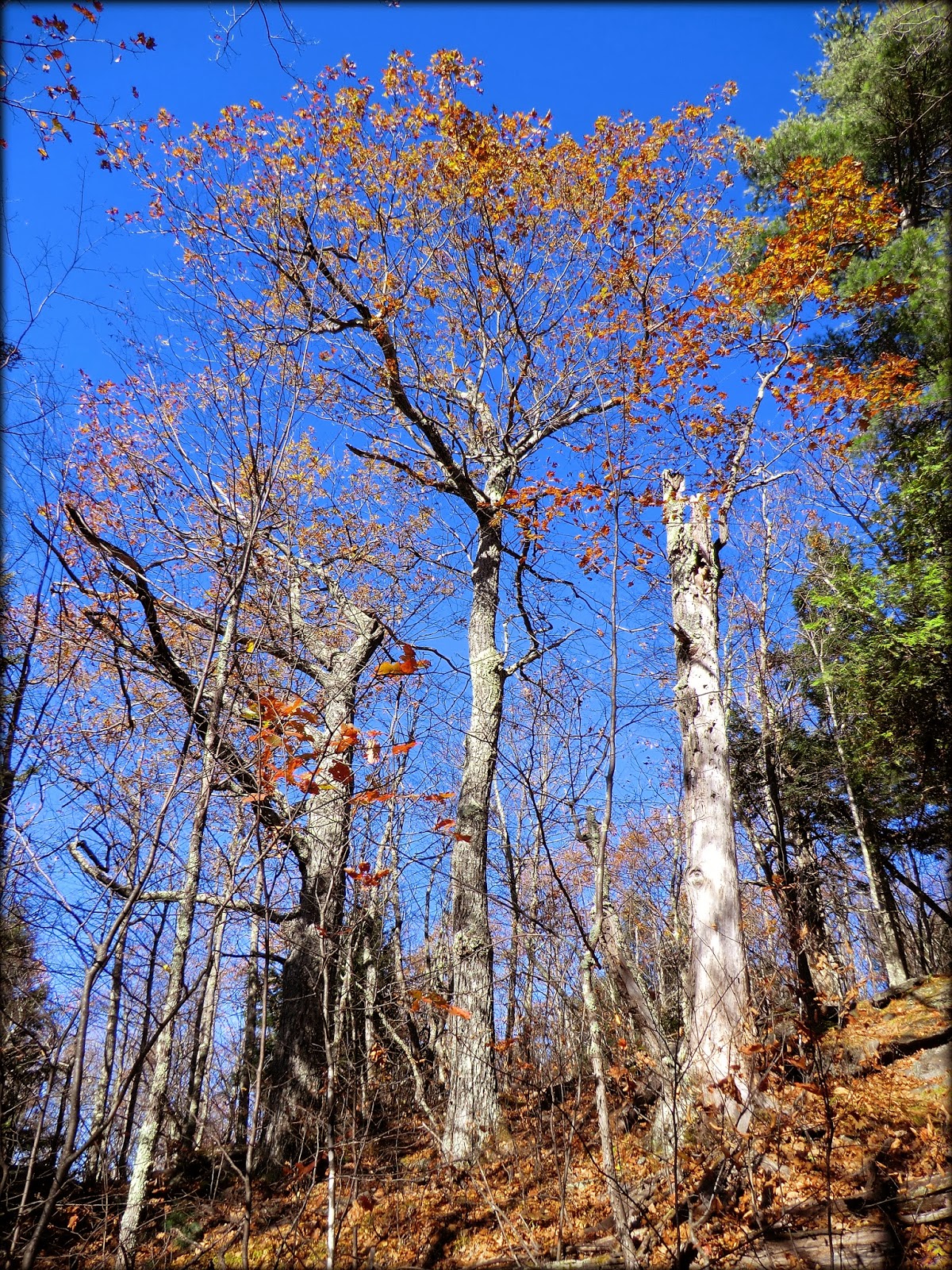
Example of some of the stately oak trees along the Round Mountain Trail
The trail has many steep spots, but there are several switchbacks to provide relief.  The steepness moderates somewhat as you come closer to the Rock Castle Loop trail.  However, the loop contains some of the steepest sections of the entire route.  Doing the loop clockwise involves a steep ascent.  And, of course, if you do the loop counterclockwise, then it involves a steep descent.  So, it's your choice as to which direction to follow!  My personal choice is to ascend steeply, and so I chose the clockwise option. Regardless of how you do the loop, there are three very fine viewpoints to enjoy along the route.

The next three photos provide examples of some of the vistas that can be seen while hiking the Round Mountain Trail.
Huge line-up of peaks on western horizon, including Baldfaces, Presidentials, Carters, and many others
Zoomed photo showcasing the peaks in Presidential and Carter mountain ranges
Low-lying Oxford Hills area in foreground with peaks in Mahoosuc Range on horizon
The Maine Trail Finder website lists this hike as 1.8 miles round-trip.  However, this description seems to have been written prior to the addition of the Rock Castle Loop.  My guess is that the round-trip mileage with the loop would be slightly over 2 miles.  And just as a side note, I commend those who constructed the Rock Castle Loop.  It's quite obvious that a lot of work went into it!

3) Browns Ledge

The open ledges portion of Browns Ledge are within the boundary of the White Mountain National Forest, and these ledges can be approached entirely on public land through open woodlands of hardwoods and conifers.   For my bushwhack, I parked along Flat Road and did a short trek of about 0.3 mile (one-way) to reach the open ledges.

There are several pleasant views from Browns Ledge.  But by far, the most striking sight is the vista of Haystack Notch with a piece of Mt. Washington and the Carter Range visible through the notch.  Caribou Mountain is on prominent display to the right of the notch, which serves to enhance the overall scene.
Portion of Mt. Washington and Carter Range seen through Haystack Notch
It is somewhat common to find a bootleg trail leading to spots such as Browns Ledge which are located just a relatively short distance from a roadway.   Admittedly, very little time was spent searching for such a trail, but nonetheless I found nothing.  Once on top of the ledge, an old cairn was spotted near the northwest corner at the edge of the woods, but no readily apparent pathway was associated with the cairn.

To sum it up, it was easy to do these three hikes in a matter of a few hours.  All were relatively short, uncomplicated hikes, and it took only a few minutes to drive between the trailheads.  And to top it off, each of these treks were new to me which always makes me 1HappyHiker! :-)

17 October 2013

Western Maine Meanderings (Mount Will, plus Bucks and Lapham Ledges)

Following an all-day, off-trail trek in the southern Mahoosucs with folks from the Shelburne Trails Club, I was in the mood for some less intense meanderings using established trails!  The location I chose was in western Maine, just a few miles over the New Hampshire border.

During my travels, I checked out several little hikes and walks.  However, this report will only focus on my trek to Mount Will, plus a trek that took me to both Bucks Ledge and Lapham Ledge.  These locations are all in relatively close proximity to each other as can be seen on the map shown below.  (Click to enlarge.)
Circled in pink are the locations of Mount Will, plus Bucks and Lapham Ledges
(CLICK TO ENLARGE)
Hike to Mount Will:

The trail is fully described at the Main Trail Finder website (click HERE), which includes a trail map, as shown below. 
Trail map for Mount Will
I did this hike as a 3.25 mile loop which includes both the North Ledges and the South Cliffs.  The open ledges and cliff tops provide views of the Androscoggin River Valley, as well as some stand-up views of Puzzle Mountain and surroundings.
View of Androscoggin River Valley area from Mount Will
View of Puzzle Mountain and surroundings from Mount Will
Located sort of midway between the South Cliffs and the North Ledges is a spur trail that leads to the Gray Memorial.  Maine State Trooper Leroy Gray, 39, and his wife, Brenda, 32, were killed when their small plane hit Mount Will at about 7:30 PM on Sept. 25, 1992.  Karen Gray (Leroy's daughter and Brenda's stepdaughter) survived the crash and spent more than 3-hours walking down the mountain to seek help. The funeral for Leroy and Brenda Gray drew nearly 1,000 people which included more than 800 uniformed law enforcement officials.
Gray Memorial site located atop Mount Will
/ / / / / / / / / / / / / / / / / / / / / / /

Hike to Bucks Ledge and Lapham Ledge:

The trail used to access Bucks Ledge and Lapham Ledge is also fully described at the Main Trail Finder website (click HERE).  This website includes a trail map, as shown below.  
Trail Map for Bucks Ledge and Lapham Ledge
This hike was done as a 2.8 mile loop.  For the return leg of the loop, it involved a 1.1 mile walk along Mann Road and a 0.2 mile walk along Rt. 26.  The road walk was pleasant enough.  However, for any future hike at this location, most likely I'll forego the road walk and simply use the same route for both the outbound and inbound leg of the trek.

It should be mentioned that although the trailhead is located on Rt. 26, it is a bit obscure.  On the day of my hike, the only indication of the trailhead was a rather rudimentary sign stuck into the ground on a wooden stake (see next photo).
Rudimentary sign at trailhead for Bucks and Lapham Ledges hike
Lapham Ledge provides an enjoyable view of Bryant Pond which lies at the base of Mt. Christopher, as seen on the right side of the next photo.
Bryant Pond and Mt. Christopher, as viewed from Lapham Ledge
Lapham Ledge is definitely worth a visit.  But in my opinion, Bucks Ledge provides better views.  From Bucks Ledge, there are excellent views overlooking North Pond, South Pond, as well as Bryant Pond a bit further to the southeast.  It was difficult to find a spot that would include all three ponds in a single photo.  The next snapshot was the best I could do.  It shows Bryant Pond (far left), South Pond (far right), and a small piece of North Pond (bottom right).
View from Bucks Ledge:Bryant Pond (left); South Pond (right); small piece of North Pond (bottom right) 
The next photo was also taken from Bucks Ledge.  The main intent of this photo is to highlight the dazzling Autumn foliage that was still present at this location in mid-October.
Autumn foliage viewed from Bucks Ledge in mid-October (Bryant Pond seen in distance)
Bucks Ledge also provides views of peaks in Evans Notch and the White Mountains beyond.  However, these views were mostly obscured by overcast conditions on the day of my visit.  Those peaks can be seen ever so faintly on the distant horizon in the next photo.
Cloud-obscured vista of peaks in Evans Notch and White Mountains on distant horizon
The next photo was taken from the roadside of Rt. 26.  It shows Bucks Ledge as viewed over North Pond.
Bucks Ledge as viewed over North Pond
To sum it up, my meanderings in western Maine involved less driving-time from my home in Bethlehem than it takes to reach many hiking destinations in New Hampshire.  And so, that was a definite "plus".  But of greater importance from my perspective, was the fact that all of the places that I visited on this meandering journey were new to me.  As any frequent reader of my Blog knows, one of my passions is doing hikes that I've never done. :-)

12 October 2013

Long Pond and The Hogsback

The title of this report sort of sounds like the title of a work of fiction, although I'm uncertain what the subject matter might be if that were to be the case!   Regardless, the topic of this report is about a short foray to Long Pond, followed by a bushwhack to a ledge along the ridgeline known as The Hogsback.

The sole purpose for making a short foray to the shoreline of Long Pond was to get a photo of Black Mountain with the pond in the foreground (see next photo).
Black Mountain (Benton, NH) with Long Pond in foreground
Before proceeding further with this report, perhaps it might be a good idea to set the scene by presenting a map that shows the area where my adventure took place.  On this map you will see both Long Pond and The Hogsback.  The route I took to The Hogsback is highlighted in yellow.
Map showing the area where my adventure took place
Following my brief stopover at Long Pond to take some photos, I continued travelling south on Long Pond Road to a gated logging road where I parked my car at a wide spot in the road.  On the map shown above, the logging road is labeled as the "Black Mountain Trail".  This corridor now bears little resemblance to a hiking trail!  The next photo shows a typical scene along the logging road, as it currently exists.
Typical scene along the logging road
I followed the logging road for about 0.8 mile and then launched a bushwhack heading westward through open woods for about 0.7 mile to reach a ledge on the ridgeline of The Hogsback.  The next photo shows the type of open woods that I enjoyed for the majority of the bushwhack.
This type of open woods was typical for the majority of the bushwhack
Upon reaching the ridgeline, I picked up the remnants of an old trail.  I don't know if this was ever an official trail.  According to old maps, there was once an official trail called the Jeffers Mountain Trail that ran along the southern part of The Hogsback's ridgeline. However, it appears to me that it veered off before reaching the ledges on the northern end of the ridgeline.  Regardless, the next photo shows a typical segment of the old trail that I followed for about a tenth of a mile before heading off to my target ledge.
Segment of old trail corridor along northern end of The Hogsback's ridgeline
In the preceding paragraph it was mentioned that I headed off the old trail corridor to reach "my target ledge".  On other occasions, I've explored the entire ridgeline along The Hogsback.  Therefore, being familiar with this location, I knew exactly which ledge I wanted to visit.

The next three photos shows some of my favorite views from "my target ledge".
Vista of Long Pond with Kinsmans and tops of Franconia Range in background
Sugarloaf Mountain, as viewed from The Hogsback
Mt. Moosilauke (dark mass on horizon), as viewed from The Hogsback
For my road trip back home, I decided to continue driving southbound on Long Pond Road to pick up Rt. 25 westbound, and then take Lime Kiln Road to Rt. 116 toward Franconia where I'd pick up Rt. 142 and head for my home in Bethlehem.

The route outlined above enabled me to make a roadside stop at Oliverian Pond to view Owl's Head cliffs (just NW of Glencliff, NH), and to also make a roadside stop on Lime Kiln Road to get a distant view of Sugarloaf Mountain and The Hogsback ridgeline which I had visited earlier in the day.

The next two photos show the vistas from these roadside stops.  Sometimes the views travelling to/from the hike can be at least as pleasant as the views experienced on the hike itself!
Owl's Head cliff (near Glencliff, NH), as viewed from Oliverian Pond
Sugarloaf Mountain and The Hogsback, as viewed from Lime Kiln Road (between East Haverhill and Benton, NH)
To sum it up, the only actual hiking that I did for this adventure was the approximate 3-mile round trip trek to the ledge on The Hogsback.  But as the saying goes, big things come in small packages!  Also, it was terrific to do this trek one more time before the forest in this vicinity is "rearranged" by the upcoming logging operations associated with the Pemi Northwest Project.

A Plain Vanilla Hike to Mt. Pierce

Chances are good that most readers of this Blog have hiked to Mt. Pierce on more than one occasion.  Deservedly so, it's a very popular hike.  Being a rather commonplace trek, the term "plain vanilla" was used to characterize my trip to Mt. Pierce.

One of my Facebook friends (Joyce West) went a step further by portraying my hike as "vanilla with a cherry on top"!  Perhaps you'll agree with Joyce's portrayal when you view the next photo showing low-growing alpine flora which turns brilliant shades of red in autumn.  Adding to the "cherry on top" analogy, this snapshot also features a hiker with a red jacket!
View from top of Mt. Pierce looking toward Presidential Mountain Range
Same view as above, but slightly zoomed
Same view again, but highly zoomed
From a point slightly below the summit of Mt. Pierce, there is "bird's-eye" view of the Mt. Washington Hotel complex.
"Bird's-Eye" view of Mt. Washington Hotel complex
On the return leg of my hike, the southward view from the Webster Cliff Trail provided vistas which included shades of orange along with dark gray shadows of late afternoon.  These colors were quite different from those experienced atop Mt. Pierce.  They were more suggestive of the upcoming Halloween season, rather than "vanilla with a cherry on top"!
View from Webster Cliff Trail looking toward Mt. Chocorua, and peaks in the Bartlett area
Although the Mizpah Spring Hut was still open as of the date of this hike in early October, there were no folks milling around the outside of this facility.  No time was taken to go inside.  I merely snapped a photo and moved on.
Mizpah Spring Hut on the Webster Cliff Trail
Just beyond the hut is a picturesque segment of trail, as shown in the next photo.
Picturesque segment of trail near Mizpah Spring Hut
To top off my journey, I took the short spur path to Gibbs Falls.  The late afternoon sun was producing a golden glow on the area surrounding the falls.
Gibbs Falls in the golden glow of late afternoon
This 6.2 mile hike was done as a clockwise loop involving the Crawford Path, Webster Cliff Trail and Mizpah Cut-Off.  My route is shown in the Google Earth image below.
Google Earth image showing my route of travel
To sum it up, normally I try to do hikes that are new to me, rather than doing repetitions of the same hikes.  Although I've done Mt. Pierce on numerous occasions, weather conditions were ideal for a high-elevation hike such as this.  And besides, who could resist a scoop of "vanilla with a cherry on top"? :-)

02 October 2013

A Short Loop Hike in Dixville Notch

On a beautiful Autumn day, I made an impulsive decision to do a 60-mile drive to Dixville Notch in northern New Hampshire.  Admittedly, it was a rather odd decision to travel such a long distance since it was already late morning by the time I finished doing some things around the house.  However, I knew the time would pass quickly with all the colorful foliage to admire along the route.  Also, the hiking options I'd chosen were short and doable in the amount of daylight hours available to me.

In the past, I've hiked to several locations in the Dixville Notch area, including the popular destination of Table Rock.  On this particular day, I chose to launch a trek from the eastern end of the Sanguinary Ridge Trail which originates at the Flume Brook picnic area in Dixville Notch State Park.  On the ascent portion of the hike up the ridgeline, there were enjoyable views looking down into Dixville Notch, and particularly nice views looking eastward toward Maine.  The Autumn foliage was near its peak in terms of brilliant colors.
Dixville Notch as viewed from an overlook along Sanguinary Ridge Trail
East view toward Maine from Sanguinary Ridge (Old Speck prominent on distant horizon)
On the descent portion of my hike, the dominant vista was that of Lake Gloriette and the Balsams Resort Hotel. The hotel is closed (as of the date of this hike).  Renovations will start once enough money is gathered to finance the project.  The owners of this legendary hotel have recently reported that once the necessary funds are procured, the project will be completed within 18 months of its commencement.  The renovation is estimated to cost around $35 million.
Lake Gloriette and Balsams Resort Hotel as viewed from a perch on Sanguinary Ridge
Looking straight DOWN from a perch along Sanguinary Ridge Trail
Compared to other places where I've hiked, the geology of Dixville Notch appears to be quite different.  My knowledge of geology is so very limited. However I seem to recall reading somewhere that the rock here is quartz monzonite versus the quartzite/mica schist that is more prominent at other places where I frequently hike.  Perhaps a reader of this Blog who is knowledgeable about geology can provide some authoritative information about the physical structure of Dixville Notch.

But regardless of the geology of the area, shown in the next 3 photos are examples of rock spires that I find fascinating since they are land features that are rarely seen on my usual hikes.
Rock spire on south wall of Dixville Notch
Trailside view of Index Rock on north wall of Dixville Notch
A different viewing perspective of Index Rock
At the western end of the Sanguinary Ridge Trail, you begin to descend into the narrow Dixville Notch.  As the two walls of the notch tighten, you see some vistas through small slits, such as shown in the next photo.
A portion of Lake Gloriette as viewed from western end of Sanguinary Ridge Trail
Upon reaching the end of the Sanguinary Ridge Trail, I had a decision to make as to how to complete my loop.  It could be done by hiking about two-miles on a very nice set of hiking trails (Table Rock Climbing Trail; Three Brothers Trail; Huntington Cascade Trail; Flume Brook Trail).  Or, I could walk for about one-mile through the Dixville Notch along the shoulder of Route 16.

Believe it or not, I opted to walk through the Notch versus the hiking trail combination described above.   Part of this decision had to do with evening fast-approaching due to my late start.   Another factor was that I actually relished the idea of walking through this small "boutique-size" notch!  It would be a totally different experience from doing yet another on-trail trek along a ridgeline high above the notch.  However, I must say that this option would never have even been considered for a larger notch such as Crawford Notch, and certainly not the Franconia Notch with Interstate 93 running through it!

Traffic was light.  Only 9 cars passed by me on my 15 minute walk through the notch.  Shown in the next photo is an example of the pleasant roadside views that I experienced.
Typical roadside view while walking through Dixville Notch along Rt. 16
When I arrived back at my car, there was still a bit of time before I needed to head home to Bethlehem.  The Huntington Cascade Trail was just a short distance away, and so I decided to launch a short hike up that trail.  However, given the time of day, and the time of year, the dim lighting was an issue with photographing the cascades.

Shown below is a composite photo of two cascades along this trail.  This is certainly not my finest piece of photography, but perhaps it will provide some idea as to how these cascades might appear under better viewing conditions.
Two cascades along Huntington Cascade Trail
The title of this report states that this was a "A Short Loop Hike in Dixville Notch".  How short was it, you might ask!  It was really short!  I guesstimate that overall, it was less than 3.5 miles (1.7 miles along Sanguinary Ridge Trail; 1.1 mile road walk along Rt. 16; about 0.6 mile out and back on the Huntington Cascade Brook Trail).

To sum it up, although the distance for this hike was small, the enjoyment was large.  As is true for so many things, it boils down to a question of quantity versus quality.  I've done much longer hikes than this one, but enjoyed them less!