Although there are no
official hiking trails that lead to the Eagle Cliff Ridge, I've made several
excursions to the northern end of ridge.
My routes have included using the remnant of an old trail that was once planned to traverse the entire length of Eagle Cliff Ridge. It begins near I-93 at Exit 34C and it takes you to a viewpoint at the first set of
cliffs. And, I've done a steep scramble up to the ridgeline via a rock climbers pathway which diverges
from the Greenleaf Trail not far from its trailhead in Franconia Notch. This route provides access to a unique rock
formation sometimes referred to as "The Watcher". (More
will be said about this later in the report.)
A few days ago, I
decided it was time to finally take the plunge and make a visit to the
southern-most end of the Eagle Cliff Ridge.
Access to this end is more difficult. There are no bootleg trails or other pathways. It's a pure bushwhack!
I've heard tale of some
who have bushwhacked to the south end of the ridgeline via the steep cliffs on
the western side. However, I opted to
use an approach from the wooded eastern side.
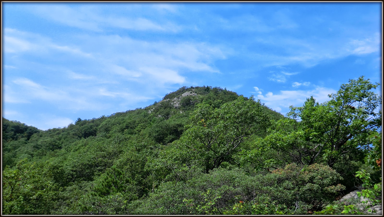
Shown below are two photos which I took a few years ago on a separate
adventure. The first photo shows the cliffs on
the western side of the ridge, and the second one shows the wooded eastern side.
 |
| West side of Eagle Cliff Ridge |
 |
| East side of Eagle Cliff Ridge |
Regarding the photo above which shows the east side of
the Eagle Cliff Ridge, you'll notice that the further north (to the right of
the photo) you go, there are more hardwoods.
I wanted to take advantage of this situation. Therefore, upon leaving the Greenleaf Trail (just
a short distance beyond Eagle Pass), I hiked a bit northeasterly toward the
interior of the ridge before I began my ascent. Although there were still patches of thick
woods at various points along the route, I'd like to think that my strategy
resulted in a route that was a bit easier than beginning my ascent farther to
the south (i.e. nearer to Eagle Pass).
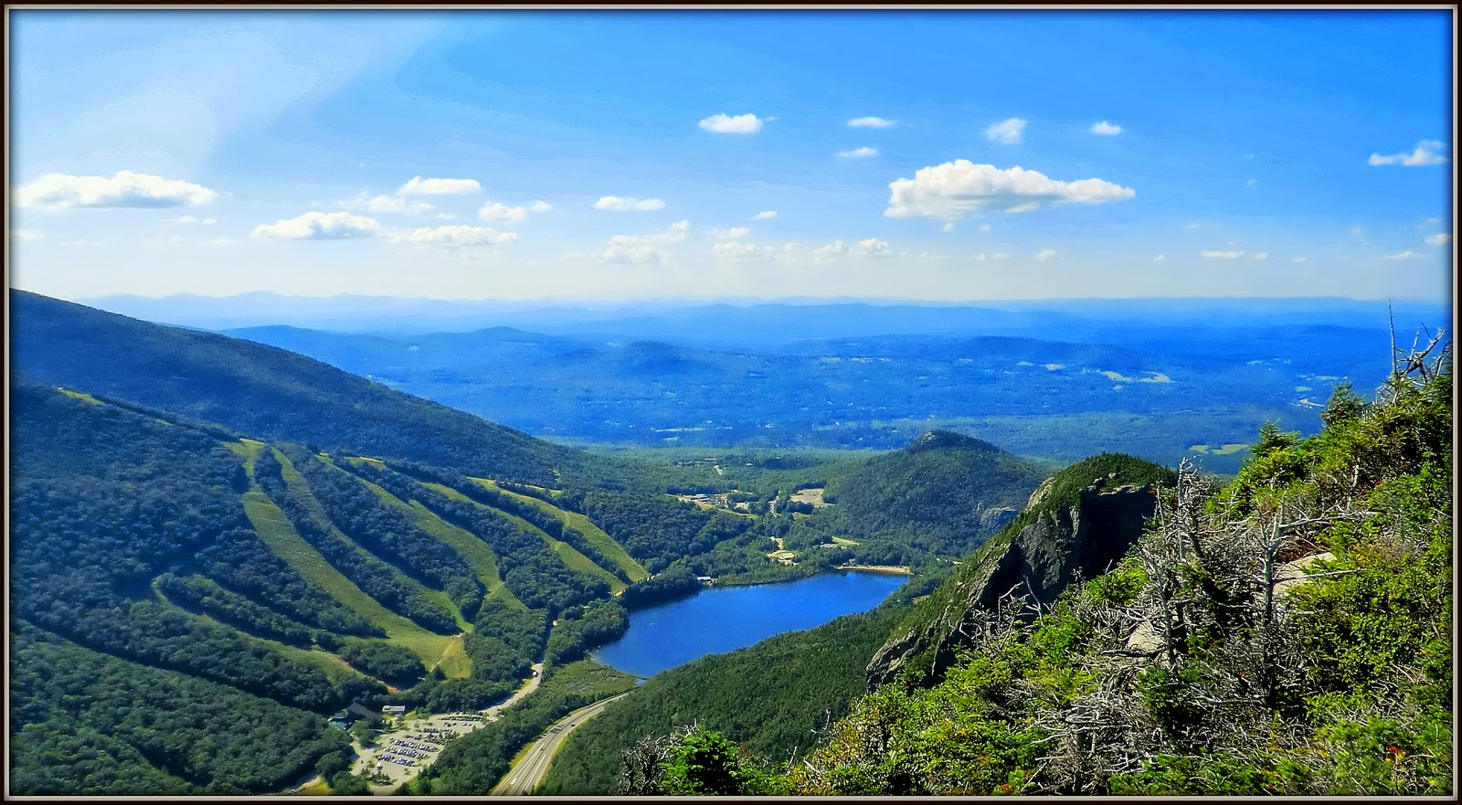
Upon reaching the open ledges at the south end of Eagle
Cliff Ridge, I enjoyed several fine views which are shown in the next series of
snapshots.
 |
| Looking up Lafayette Brook valley toward the Mt. Lafayette ridgeline |
 |
| Looking directly across I-93 toward Cannon Mtn with Profile Lake in foreground |
 |
| Looking south down I-93 (Cannon Cliffs at center right; Profile Lake at bottom right) |
 |
| Another southward view from a ledge near the top of Eagle Cliff Ridge |
 |
| Northward view showing Cannon ski slopes, Echo Lake, Bald Mtn and Artist's Bluff |
From the southern end of the Eagle Cliff Ridge, I could see
in the distance many of the features that I'd seen up-close during my past forays near the
northern end of the ridge. One such
feature was 'The Watcher'. She is also
known as 'The Old Lady of the Mountain', and as 'The Old Woman
of the Notch'. The
"person" of whom I speak is the natural rock profile on the side of
the Eagle Cliff Ridge. The profile
appears to be that of a woman's head and face, and it appears as if she is
"watching" for strangers approaching the Notch from the east.
This profile is not as
well known as the "Old Man of the Mountain" who once graced Cannon
Mountain on the opposite side of the Franconia Notch. In 2003, the rock configuration that formed
this iconic image fell to its "death" due to natural causes.
There are several legends
about the relationship between the 'Old Man' and 'The Watcher'. One of which is
that the Peregrine Falcons, which routinely soar from one side of the Notch to the
other, were used by 'The Watcher' and the 'Old Man' as a means to exchange messages
with each other. Even knowing that it's
just a legend, nonetheless, it's still quite sad to think about the message
that would have been delivered by the falcons to 'The Watcher' on that fateful
day of May 3, 2003 when the 'Old Man' tumbled.
Shown below is a
composite image showing the profile of 'The Watcher' as viewed from the south
and from the north. Just as a side
note, by using binoculars you can get a view of the profile from the south by
standing at certain spots at the floor of the Franconia Notch. However, the only way to get the view of the
profile from the north is to do a steep climb to the Eagle Cliff Ridge which I've done on several occasions.
 |
| Composite image showing 'The Watcher' viewed from the south and from the north |
My view of 'The Watcher' from the south end of Eagle
Cliff Ridge was a frontal view (see next photo). The
location of 'The Watcher' is circled in red. As can be seen, this formation is nearly
impossible to recognize, unless it is seen as a profile.
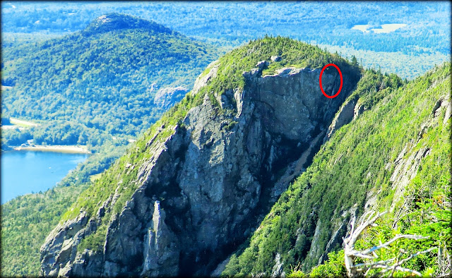 |
| A view of 'The Watcher' as seen from south end of Eagle Cliff Ridge |
Located slightly below 'The Watcher' is the Eaglet which is
another feature nearer to the north end of the ridgeline that I could see from my
vantage point at the southern end of Eagle Cliff Ridge. Shown below is a photo of the Eaglet which I
took several years ago when trekking near the northern end of the ridge.
 |
| Photo of 'Eaglet' taken several years ago near north end of Eagle Cliff Ridge |
The next photo is a composite image. On the left is the 'Eaglet', as viewed
during my trek to the south end of Eagle Cliff Ridge. On the right is a captioned set of photos
from a newspaper article about climbers who scaled this rock formation.
 |
| 'Eaglet' viewed from south end of Eagle Cliff Ridge (left); newspaper article (right) |
Here are a few bits of miscellanea associated with this
trek. The high point (3,420 ft) of the
Eagle Cliff Ridge is located at its southern end. There is a summit canister and log book for
peakbaggers to sign. Although I'm not a
peakbagger, I will often sign a log book, when I
think of it. This time I thought of it,
but forgot to sign in. Oh well, there's
always next time!
This was an out-and-back trek using the same basic route
for both the outbound and inbound leg of the journey. I didn't get on the trail until nearly 1 PM
and so my timeframe was short. If I'd
gotten an earlier start, it would have made a nice loop to have continued
northward along the ridge to 'The Watcher' and then descended to the Greenleaf
trail via the pathway used by rock climbers.
In terms of distance, I'd guesstimate my round-trip to be
only about 4.5 miles.
Shown below is one last photo. On a ledge near the high point of the
ridgeline, I came across a piece of metal hardware cloth. It's anyone's guess as to how this item got
to this spot. Did someone actually
schlep it up there for some unknown reason?
Did a strong updraft swoop it to
the top of the ridge from the floor of the notch? Did it fall off a helicopter that was
transporting items to the Greenleaf Hut?
 |
| Metal hardware cloth seen near the high point of Eagle Cliff Ridge |
To sum it up, this trek was a perfect fit for my timeframe, and it
was a thrill to visit a destination that was new to me. My only regret is that I didn't get an
earlier start which would have enabled me to do a loop hike that could have
included a revisit to features such as 'The Watcher' near the northern end of
the Eagle Cliff Ridge.
/////////////////////////////////////////////////////////////////////////
POSTSCRIPT:
Click HERE for a link to another of my blog postings about destinations along Eagle Cliff Ridge.