
 |
| Route of travel as depicted on GoogleEarth image (click to enlarge) |
The idea for this hiking adventure came to me a few days
ago when I was doing some general meandering off the Davis Path (click HERE for
details about that trek).
During the short off-trail hike referenced above, I
visited the unnamed brook that runs in the valley between the ridge to the east
where the Davis Path is located, and the ridge to the west where there is no
trail. I noticed that the slope along the
ridge on the west bank of the brook appeared very inviting as it rose
northward. This prompted me to look at a
topographic map when I returned home.
One thing led to another, and it wasn't long before I was plotting out a
course for the adventure that is the subject of this report.
The bushwhack portion of this loop hike seemed no steeper
to me than the climb on the Davis Path. Also,
my round-trip hiking time of just under 5 hours was comparable to the book time
(4 hours 38 minutes) that is listed for a conventional "out and back" trek using
the Davis Path exclusively.
The vast majority of the hike was through open
hardwoods. However, there were a few short
segments consisting of a mixture of conifers and hardwoods. The longest portion of these mixed (and less
open) areas was between the spot labeled above as "Ledge #2", and the
point where open ledges begin to appear to the west of Mt. Crawford's summit.
And so, that is the background for this adventure. The remainder of this report will consist
mainly of photos with some brief narration about the photos. I'll
skip a presentation of the historical aspects associated with this trek. Most readers of this Blog are already
familiar with facts such as the Davis Path was constructed by Nathaniel T. P.
Davis, and it has been in existence since 1845.
The first snapshot was taken on the outbound portion of
my trek as I was ascending the lower part of the Davis Path. For whatever reason, I'd never noticed this
large triangular shaped boulder off the side of the trail. It looked like a miniature pyramid when I
first spotted it.
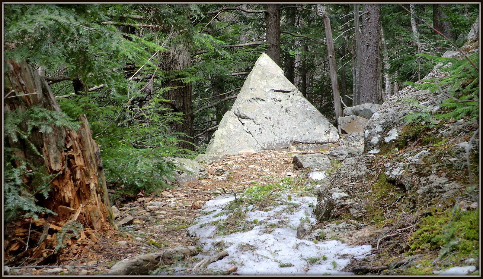 |
| Trailside boulder shaped like a pyramid (located on lower portion of Davis Path) |
Referring back to the Google Earth image shown above,
you'll note that there are spots labeled as "Ledge #1", and
"Ledge #2". Although I
encountered more than two ledges during the bushwhack, these are the ledges from which I
took photos.
Shown below is the view from Ledge #1 looking southward (Mt.
Tremont is in center of photo).
 |
| View from Ledge #1 looking southward (Mt. Tremont is in center of photo) |
Ledge #2 consisted of a complex of several ledges. Shown below are two snapshots taken from the
Ledge #2 area.
 |
| Looking northward up the Crawford Notch from Ledge #2 |
 |
| Tops of Presidential Range as viewed from Ledge #2 |
After leaving Ledge #2, I headed eastward toward the
summit of Mt. Crawford. As mentioned
earlier, the woods were less open for this portion of the journey. However, within 20 minutes I started to hit
the wide open ledges on the west side of Mt. Crawford (about 0.1 mile below the
summit). From here the imposing view of
Stairs Mountain came into view. The next
photo is a zoomed view of that mountain with its unique stair step shaped
cliffs.
 |
| Zoomed view of Stairs Mountain |
Backing off from my zoomed view, here are two more
snapshots which also include Stairs Mountain.
The first one shows the view to the north of Stairs, and the second one
shows the view to the south of Stairs.
 |
| Stairs Mountain with the snow-capped Presidential Range behind it on the left |
 |
| Stairs Mountain with Mt. Resolution to its immediate right |
Besides Stairs
Mountain, there are many other impressive views from these ledges located below
the summit of Mt. Crawford's western side.
One such view is looking northwestward toward the Crawford Notch area
(next photo).
 |
| Crawford Notch and surroundings as viewed from ledges below Mt. Crawford's summit |
After spending
quite a bit of time enjoying the views from the ledges below the summit, it was
time to make the final ascent to the top of Mt. Crawford and meet up with the
Davis Path. The next photo shows the
scene looking up at the summit of Mt. Crawford from ledges on its western side.
 |
| Looking up at summit of Mt. Crawford from ledges on its western side |
Once on top of
the summit, I noticed the small memorial consisting of a bird sculpture
surrounded by several colorful stones. I
posted an image on Facebook and asked if anyone had any details about this
particular memorial. In response, a
Facebook Friend (Dan Szczesny) kindly provided me with a photo he had taken of
this same memorial in October 2012. By
the way, Dan authors a great Blog (click HERE) which I'd encourage you to
visit.
Although I still
don't know any details about the memorial itself, it's interesting that it has
endured on the mountaintop for at least several months (maybe longer). The next photo is a composite image showing
the memorial as it existed in October 2012 when Dan visited Mt. Crawford, and a
photo showing its appearance on my April 2013 visit. It's sort of amazing that it has remained pretty much
intact over the months. The "Remember" stone is missing, but it might
still be up there somewhere. It could
have been accidently kicked aside.
 |
| Memorial on Mt. Crawford as it existed in October 2012 vs. April 2013 |
Although viewed from
a slightly higher vantage point, and from a slightly different angle, the vistas from
the top of Mt. Crawford are similar to those that I presented in the photos taken from the ledges located
0.1 mile below the summit.
I lingered for
just a short time on Mt. Crawford and then began my descent to the trailhead
via the Davis Path. Early on into my
descent, I stopped to take a photo from one of the last open ledges before the
trail is immersed in the trees for the remainder of the trip. The vista in this photo is looking
southward. The Attitash ski slopes are
on the left. Various peaks in the
Sandwich Range are on the distant horizon, including the sharply pointed peak
of Mt. Chocorua (slightly right of center).
 |
| View from open ledge near the point where Davis Path becomes immersed in trees |
To sum it up, I'll
simply repeat what I said at the outset of this report. This was a thoroughly
enjoyable loop hike. It ranks highly in
terms of my most favorite adventures to date. But to each their own, as
the saying goes. Some might do this trek
and come away with a totally different opinion!
////////////////////////////////////////////////
ADDENDUM: Subsequent to this adventure, I did a similar trek in August 2015, but used a route that differs from the one described in this blog posting. Click HERE to access my August 2015 posting.
////////////////////////////////////////////////
////////////////////////////////////////////////
ADDENDUM: Subsequent to this adventure, I did a similar trek in August 2015, but used a route that differs from the one described in this blog posting. Click HERE to access my August 2015 posting.
////////////////////////////////////////////////
6 comments:
Hi John, great and informative post, like usual! After our hike last October, this became one of my favorite places in the Whites. I'm eager to explore the rest of the Davis Path soon. Thanks for the shout out!
Thanks guys for your comments!
Mt. Crawford and the surrounding ledges do indeed provide some of the best views in the Whites, in my opinion. It’s easy to understand why this location has become one of your favorite places.
Regarding the Davis Path, it’s an amazing piece of work. However, I still have a problem wrapping my head around the fact that it was designed as a bridle path. There are many spots along this trail that seem too steep for horses. But maybe it was okay back in the days when men were men, and horses were horses?! :-)
John
Great loop John. As you know from reports of mine I'm dying to explore all the ledgey goodness in that area. I do not remember seeing that memorial last summer so I'm guessing it was placed sometime after that.
Thanks for sharing,
Joe
Hey Joe . . . I do indeed recall your explorations in that area. There’s one of your reports that I particularly recall:
http://justjoehiking.blogspot.com/2012/09/crawford-east-stairs-and-ledge91312.html
That’s an interesting bit of info about the memorial not being there when you visited Mt. Crawford last summer. There’s likely a wonderful story about the motivation for placement of this little commemorative.
Thanks for posting your comments!
John
Wow, John. This looks like an amazing hike. The views are simply spectacular and the weather was great! This post has got me in the mood for some spring mountain hiking. (But many of our mountain trails are still snow-covered and we don't feel like unpacking the snow shoes!)
You say you did the hike in just under five hours. What was the total mileage?
I see there's still snow on the ski slopes and at the summit—that's a good sign, I guess!
I like the little memorial that you found—wonder what the story behind it could be?
I checked out the blog of your facebook friend, Dan. It's a fun read!
Another great post, John!
Hi Rita,
First of all, thank you so much for taking time to do such a thorough read of my recent blog posting. Also, thank you for taking time to check out Dan’s blog. I’m certain he is grateful for that.
Yes, that little memorial atop Mt. Crawford is certainly intriguing! As indicated in my reply to Joe, I can’t help but feel that there’s a wonderful story about the motivation for placement of this little commemorative.
And yes, we still have snow and ice lingering on many of our trails here in the White Mtns of NH. Although it’s a good indicator that we had a terrific winter, it’s now time for it to go away! It’s unpleasant to hike in these mixed conditions of dry trail, then wet trail, then ice, then snow.
Okay, the mixed conditions described above bring me to your question about the total mileage for this trek. I guesstimate it was about 5.5 miles. Hiking that distance in about 5 hours is rather slow for me. On a flat trail (or downhill), I can usually average at least 2.5 miles/hr. However, on this hike there was a significant off-trail component, and this ate up some time for “on-the-fly” route-finding. Also the outbound leg of the trip was a moderately steep uphill climb which slowed my pace. And, although the inbound leg was downhill, it consisted of snow-covered ice for about 1.5 miles, which also caused my pace to be a bit slower than usual. I know, I know! Excuses! Excuses! :-)
Thanks again Rita for your comments!
John
Post a Comment