Pages

About Me

My photo
Bethlehem, New Hampshire, United States
E-mail contact: randonneur8@yahoo.com | Facebook: facebook.com/1HappyHikerNH

Text Above Search Box

SEARCH MY BLOG USING TEXT BOX SEEN BELOW:

31 January 2016

A Winter Hike to Mt. Pisgah (near Westmore, VT)

Most of my hiking is done within the State of New Hampshire where I live.   However, there are many hiking opportunities in Vermont that are about an hour's drive from my home in Bethlehem.   In early January 2016, I hiked to Mt. Pisgah (2,751 ft) which is located along Rt. 5A near the village of Westmore, VT.  This area lies within a region known as the Northeast Kingdom.

This trek was a simple "out and back" hike using the entire length of the South Trail, plus a segment of the North Trail was used to visit various overlooks along that trail.  The round-trip journey was about 4 miles with an elevation gain of about 1450 ft.   I've hiked to Mt. Pisgah during the warm-weather months, but this was my first winter ascent.

There is some interesting history associated with this region relating to the French & Indian War (1754-1763).  In 1759, Robert Rogers led his Rangers on a successful raid of the Abenaki Indian settlement of St. Francis in Quebec, Canada.  This raid was in retaliation for the Abenaki attack on a retreating British unit while under a flag of truce.  After the raid, Rogers and his men were pursued through northern Vermont by French and Indian forces as they made their way back to base.  As part of their escape route, the men hugged the rough and rocky eastern shoreline of Lake Willoughby at the foot of Mt. Pisgah.

Map showing trails and major overlooks for the Mt. Pisgah hike
While driving north on Route 5A en route to the trailhead, there is a surrealistic image of Mt. Hor and Mt. Pisgah that suddenly comes into view (Mt. Hor on left; Mt. Pisgah on right)
Picturesque woods and nice snowshoe track en route to the top of Mt. Pisgah
On the way to the top of Mt. Pisgah is Pulpit Rock which is a small ledge with a sheer drop off
From Pulpit Rock the view includes south end of Lake Willoughby, as well as Mt. Hor.
Nearing the top of Mt. Pisgah
The actual summit of Mt. Pisgah is a nondescript spot in the woods with a sign to let you know you've arrived!
The next two photos were taken from lookouts located north of Mt. Pisgah's summit. Each of these lookouts involve venturing out onto small ledges located atop the vertical cliffs on the east side of Lake Willoughby. 
Looking toward south end of Lake Willoughby
Looking toward north end of Lake Willoughby. (Near top/center of photo, the massive cliffs of nearby Mt. Wheeler can be seen.  This is another awesome hike in VT.)
Looking northwesterly from the outlooks off the North Trail.  Off in the distance, near the center of the photo, you can see the snow-covered ski slopes on Jay Peak which is located just a few miles from the Canadian border.
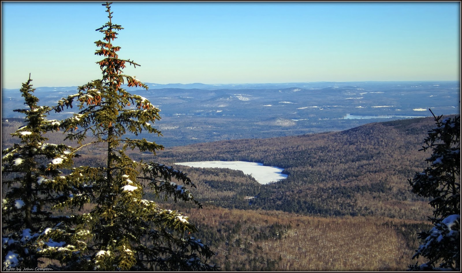
From a large ledge located just a few hundred feet east of Mt. Pisgah's summit, there are some eastward views toward the high peaks in NH (about 50 miles away).  This is a poor image, but it shows one such view.  At far left is a portion of the ski slopes on Burke Mountain (VT), and in the distance are peaks in the Franconia/Kinsman Range.  (The ski slopes on Cannon Mountain are faintly visible near top/center.)
After arriving back at the trailhead, I did a short 0.2 mile "hike-ette" along a trail  leading to the south end of Lake Willoughby.  From this end of the lake, there is a rather stunning view looking northward.  Lake Willoughby is a glacial lake reaching a depth of over 300 ft. in places.  Because of how it is dramatically situated between the steep cliffs of Mt. Pisgah and Mt. Hor, it has a resemblance to a Norwegian fjord.
Lake Willoughby front and center; Mt. Hor at left; Mt. Pisgah at right.


~ THE END ~

27 January 2016

A Hike to North and South Doublehead Mountain (Jackson, NH)

INTRODUCTION:

Doublehead Mountain in Jackson, NH consists of two peaks (North and South Doublehead) and is sometimes referred to simply as "The Doubleheads".  It had been a while since I hiked to this mountain, and so in early January 2016 I decided to make a return visit.  The Doubleheads provide expansive views of many high peaks in the White Mountains, but the starring-role in my opinion belongs to the view of the Presidential Range and the distinctive U-shaped Carter Notch.

My hike began and ended on the Doublehead Ski Trail by doing a lollipop route (counterclockwise) which incorporated the Old Path and a segment of the New Path.  The loop provides a respectable workout with about 1,800 ft elevation gain, and a round-trip mileage of about 4 miles.

PHOTOS:
Trails used for this hike are highlighted in yellow at top right of map
Doublehead Mountain as viewed from a point along Dundee Road near the trailhead
A big view looking westward from South Doublehead.  Mt. Carrigain is most prominent bump on the horizon at far left of photo; Mt. Washington is unmistakable at right of photo; Carter Notch is at far right.
Zooming in on Carter Notch
The cabin on North Doublehead was occupied and judging by the smoke billowing from the chimney, the  tenants were warm and cozy with a fire in the fireplace.  (As if the date of this posting, details about how to rent this cabin can be obtained by clicking HERE.)
At the center of this photo (taken from North Doublehead) is a body of water known as Mountain Pond which is another short, but worthy, hiking destination!
This slightly zoomed image was taken looking southwesterly from South Doublehead.  At center of photo is North Moat Mountain with the very tip of Mt. Chocorua peeking over the top.
On the way home from hiking the Doubleheads, I just happened to drive by the Mt. Washington Hotel at precisely the right time of day to catch an impressive display of alpenglow on the Presidential Range.  It was a magnificent ending to a fabulous day!


~ THE END ~

19 January 2016

A Winter Trek to Black Mountain (Benton, NH)

INTRODUCTION:

Beginning with this posting to my blog, I am going to try something that is new to me by reducing the narrative, and putting more emphasis on captioned photos.  Should a reader desire more detailed information, I am most willing to reply to questions/comments posted to this blog; or, an e-mail can be sent to me (click HERE for address).

This trek to Black Mountain (Benton, NH) was a simple "out and back" hike of about 3.6 miles (round-trip).  It was done in mid-January 2016 using the Chippewa Trail.

Black Mountain is on a list known as the "NH 52 With-a-View" (click HERE).   Also, any reader who wants more details about this particular mountain can find a wealth of information by clicking HERE.

PHOTOS and MAPS:
Map showing the location of Black Mountain (highlighted in pink at upper left of map)
One of several ledges along the Chippewa Trail BEFORE reaching the summit of Black Mountain
Photo taken a few steps away from Black Mountain's summit.  Mt. Moosilauke is seen in background, partially obscured by clouds.
Vista looking northeast to east from summit area of Black Mountain.  Kinsman mountain range at left; Mt. Moosilauke at right.
Closer view of massive Mt. Moosilauke featuring the cavernous Tunnel Ravine (a.k.a. Benton Ravine)
Highly zoomed view of Mt. Moosilauke's Tunnel Ravine (a.k.a. Benton Ravine)
Topographic map showing location of Mt. Moosilauke's 5 major ravines
Looking northeasterly with Kinsman mountain range just left of center, and Mts. Liberty and Flume faintly visible BEHIND Kinsmans near center of photo.
Zooming in on Mts. Liberty and Flume (on horizon, near center of photo)
Looking westward near the end of the day. Some of Vermont's high mountain peaks are visible on distant horizon.
A couple of the trail signs seen along the route to Black Mountain


~ THE END ~