Pages

About Me

My photo
Bethlehem, New Hampshire, United States
E-mail contact: randonneur8@yahoo.com | Facebook: facebook.com/1HappyHikerNH

Text Above Search Box

SEARCH MY BLOG USING TEXT BOX SEEN BELOW:

27 October 2014

A Visit to a New Hampshire Historic Place Known as Old Hill Village

Thanks to info provided to me a few months ago by a Facebook friend (Suzanne Reihs Moore), my wife and I recently spent an enjoyable afternoon walking for several miles at a place called Old Hill Village.  It's located on the western edge of the Lakes Region, just a short distance from the present day village of Hill, NH.  We began our trek from a parking area at the Needleshop Recreation Area located at the end of Old Town Road.

The village of Hill that existed pre-1930 was representative of many small, rural, New England towns.  There was one major tree-lined road which extended along the contour of the Pemigewasset River.  The Boston and Maine Railroad ran along the river's bank and was a major source of public transportation and shipping. Small farms dotted the surrounding countryside. Most residents worked in town, although some commuted to nearby towns such as Bristol and Franklin.

In February 1937, the residents of Hill learned that their village would have to be either disbanded or relocated in order to accommodate the Franklin Falls dam project.  The citizens carefully considered all their options and by January 1940, they had formed an association, purchased land, and began construction of a new village on higher ground just a short distance away.  Amazingly, by June 1941 a new town hall and school were built, along with streets, a water system, and 30 houses.

Within the Old Hill Village, there are no actual buildings or houses remaining since all structures had to be razed to ensure that there would be no manmade debris in the impoundment area for the Franklin Falls flood control project.  Only 14 buildings from Old Hill were saved.  This was done by moving them to higher ground using a railway and a winch turned by horses!

The Franklin Falls dam project was designed to prevent flood damage to downstream communities during times of high water.  The former village of Hill was "sacrificed" since it was located within an area that would become what is known as a "dry bed reservoir".  Throughout the year, some water is always stored behind the dam, but most of the river water is allowed to flow through the dam.  However, after a large rainfall or a period of rapidly melting snow, more water is impounded behind the dam and it fills the "dry bed reservoir".   Once conditions  improve, the impounded water is slowly released through the dam.

The illustration shown below depicts the general location of the Old Hill Village and the present-day town of Hill, NH.
Illustration depicting the general location of the Old Hill Village and the present-day town of Hill, NH
For anyone interested in learning more about Old Hill Village, the Hill Historical Society has some reasonably priced maps/publications that are very informative and useful.  (Click HERE for a link to their website.)

Shown below are a few photos taken on the day that my wife and I visited Old Hill Village.
Historic marker near south end of Old Hill Village
An old foundation and stairs
In the northern part of Old Hill Village you can still see the sidewalk the ran along the main street of town
Still standing in many places are stately trees that once lined the main street of Old Hill Village
A field behind the main street that might have once been someone's backyard in Old Hill Village
A brook that runs through Old Hill Village was used as a power source for many things, including a saw mill and a grist mill.
Abutment for bridge that once crossed the Pemigewasset River and linked Old Hill Village and Sanbornton, NH
To sum it up, our exploration of Old Hill Village was a unique and enjoyable experience.  We spent a couple of hours walking along the main street of town, and along some of the pathways near the river.  However, there are still other areas within the Old Hill Village area that we hope to explore on another visit.

////////////////////////////////////////////////////////////
ADDENDUM (added 28-Oct-2014):

This addendum is for those of us who enjoy studying maps!  The composite map below shows the village of Hill as it appeared on topographic maps before relocation (left panel) and after relocation (right panel).
(Click/tap to enlarge)

17 October 2014

CANADA: Mont Owl's Head, and Le Parc National du Mont Megantic

Living in northern NH, it's a relatively straightforward matter to take short trips to hike the mountains of ME, VT, NY, and even across the border into Canada.  Recently, my wife and I did a short loop through Canada that took us to two locations: 1) Mont Owl's Head, and 2) Le Parc National du Mont Megantic.

The map shown below will provide a general overview of our route of travel.
Our route of travel for our visit to Mont Owl's Head and Le Parc National du Mont Megantic (Click/tap on map to enlarge)

1) MONT OWL'S HEAD:

Mont Owl’s Head is located on the western shore of Lake Memphremagog in the Eastern Townships of Quebec near the town of Mansonville (about 12 miles over the Canadian border from North Troy, VT).  Besides offering some of the best alpine skiing in Quebec, this mountain also has a number of seasonal hiking trails developed by Missisquoi Nord in partnership with the Owls Head Ski Resort.
Hiking Trails on Mont Owl's Head
As we had hoped, our visit to Mont Owl's Head occurred near the peak of the Autumn foliage season. The next 6 photos show some of the many colorful scenes that were experienced from various spots along the hiking trails.


From one of the ledges on Mont Owl's Head, I was able to capture a vista looking across the U.S./Canadian border and see mountains in Vermont's Willoughby Gap area, and also see high peaks in White Mountains of NH.
Highly zoomed photo looking across U.S./Canadian border and seeing mountains in Vermont's Willoughby Gap area, as well as high peaks in White Mountains of New Hampshire
In the evening after hiking the trails on Mont Owl's Head, there was a totally unexpected treat!  We had the rare opportunity to experience alpenglow on autumn foliage.  Alpenglow only lasts for a few precious seconds.  We just happened to be at the right place at the right time.  And more importantly, we had a camera to capture "the moment"!
Alpenglow on Autumn foliage at Mont Owl's Head
Here is a tidbit of trivia associated with Mont Owl's Head.  In the 1880's the luxurious Mountain House hotel was built on the shore of Lake Memphremagog at the foot of Owl's Head.  The hotel burned in 1899 and was never rebuilt.  However, when it was in operation, there was a hiking trail from the hotel to the summit of Mont Owl's Head.  Although I'm unable to verify it, I'm told that remnants of this old trail are used by segments of the current day trail named Sentier Panorama.  While hiking the upper portions of the Sentier Panorama, I spotted occasional faded red blazes, and I wondered if perhaps these could possibly be markings from that old trail.
On upper portion of Sentier Panorama trail, there were a few faded red blazes which might have been holdovers from an old trail from the late 19th century.
A placard along the Sentier Panorama trail

2) LE PARC NATIONAL DU MONT MEGANTIC:

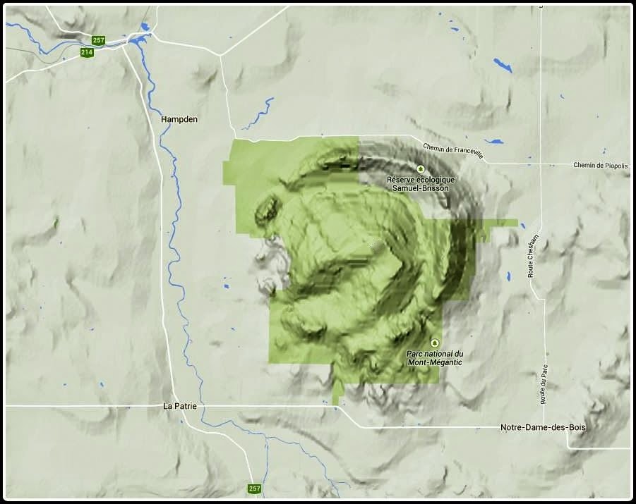
When viewed on a relief map, it becomes obvious why the Mont Megantic area is considered as a good example of one of the circular mountain formations on the east coast of North America that are of volcanic origin and known as ring dikes.
Relief map showing mountains within Le Parc National du Mont Megantic
The mountains of Le Parc National du Mont Megantic dominate the area near the Quebec village of Notre-Dame-des-Bois (less than 25 miles over U.S./Canadian border).
View of Mont Megantic mountains from the Quebec village of Notre-Dame-des-Bois
There are maintained hiking trails to the Park's 3 main summits: Megantic (3,625 ft); Saint Joseph (2,877 ft), and Victoria (2,866 ft).  Two of those summits (Megantic and Saint Joseph) can be reached via auto road.  (On this trip, my wife and I "cheated" and took the auto road!)

The main summit (Mont Megantic) is part of the International Dark Sky Places Program which promotes preservation and protection of night skies across the globe.  Located on this mountain is the Mont Mégantic Observatory which is the first such site to be recognized (in 2007) as an International Dark-Sky Reserve.
Mont Megantic summit as viewed from Mont Saint Joseph
On the summit of Mont Saint Joseph is a rustic Jesuit chapel which was erected in the 19th century to receive the patron saint’s protection against the strong winds and storms common to this region.
Chapel erected in 19th century on Mont Saint Joseph to receive patron saint’s protection against strong winds and storms common to this region
On the day of our visit, it was very overcast with occasional rain showers.  But even though viewing conditions were less than ideal, there were still some nice vistas, and it was well worth the trip.
A viewing station on Mont Saint Joseph
To sum it up, it difficult to believe that 5 years have passed since last visiting the Eastern Townships of Quebec (click HERE to read my report about that trip).  This most recent trip has inspired us to make more frequent visits to Canada in the upcoming years.


14 October 2014

Re-Discovering a Forgotten Cascade near Mt. Willard

Thanks to a friend (Joanne Jones), I was made aware of an article entitled "Mount Willard Ramblings" written by Henry E. Childs which was published in the December 1945 edition of Appalachia (America’s oldest mountaineering and conservation journal, published continuously since 1876).  Contained within this article is a description of a cascade located near Mt. Willard.  The author dubbed it as "New Cascade".

Following an earlier failed attempt,  I was finally able to locate "New Cascade".  It's situated in a deep gorge about 0.3 mile SSW of Mt. Willard, and it sits at an elevation of about 2,350 ft.   The cascade is fed by an unnamed tributary to Willey Brook.  In Childs' article (shown below), he proposed that this tributary be named Willard Brook.

I launched my bushwhack to "New Cascade" from a roadside pull off on the west side of Rt. 302, (just a bit south of the parking area for Silver Cascade).   It's only about 0.4 mile from the road to the cascade.   However, there is an elevation gain of nearly 850 ft. over this short distance.  Yes, it's a very steep climb!   But, on the plus side, there was generally good footing and open hardwoods when bushwhacking near the rim of the gorge on its north side. 
Google Earth image showing location of "New Cascade".   If you click/tap to enlarge this image you will see a white line on the ledge below the spot labeled as "New Cascade".  This could be yet another cascade.  I was unsuccessful in being able to spot this from above when trekking along the rim of the gorge.  So, this might be another adventure for another day!
Excerpt from article written Henry E. Childs in the December 1945 edition of Appalachia
(Click HERE to read more about the "Willard dwelling on the railroad" that is mentioned in the above excerpt.)
One of several sections of pipe found near "New Cascade", as is mentioned in the excerpt from Henry E. Childs' article shown above.
This snapshot shows the pool at the bottom of "New Cascade" that is mentioned in the article written Henry E. Childs.  The old piping led directly to this pool!
Besides "New Cascade", there are several other cascades in this gorge, some of which are shown in this collage.  The third panel shows an obstructed view of a particularly large cascade. To safely get an unobstructed view would require some careful maneuvering.  (The angle of the fallen tree at the lower right of the photo will give some idea as the steepness of the walls of the gorge.)
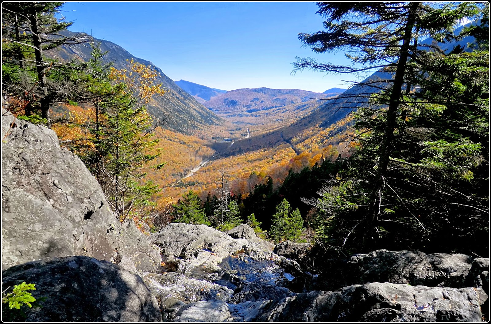
At the base of one of the cascades is this view looking southward down the Crawford Notch.  This vista was just as rewarding to me as the discovery of "New Cascade"!
At the beginning of this blog posting, I mentioned a prior attempt at finding "New Cascade" which ended in failure.   On that endeavor, I hiked along Willey Brook for a short distance and then branched off to the unnamed tributary where I was able to travel for some distance along a narrow and gnarly shelf at the base of a cliff.  However, the shelf eventually faded away.  Then there was nothing left but a very steep climb up the brook bed which consisted of a jumble of broken and slippery rock.

I abandoned the attempt since it was felt to be unsafe.  Also, it seemed like an impractical routing to run piping up to "New Cascade".   However, I must quickly add that some random segments of old pipe were found near the confluence of the unnamed tributary and Willey Brook.  As to why it was there, it's anyone's guess.  Maybe water was piped from more than one source?  Or, maybe the pipe washed downstream from "New Cascade"?
Looking down the narrow and gnarly shelf at the base of a cliff
Looking down the  jumble of broken and slippery rock that was encountered after the narrow and gnarly shelf faded away
To sum it up, this was a fun adventure and a rare opportunity to re-discover a forgotten landscape feature that was dubbed as "New Cascade" by Henry Childs back in 1945.