Pages

About Me

My photo
Bethlehem, New Hampshire, United States
E-mail contact: randonneur8@yahoo.com | Facebook: facebook.com/1HappyHikerNH

Text Above Search Box

SEARCH MY BLOG USING TEXT BOX SEEN BELOW:

28 January 2013

The Abandoned Black Brook Trail on Cherry Mountain


In current times, there are two trails that hikers can use to launch treks to the peaks named Mt. Martha and Owl's Head, both of which are located on Cherry Mountain. There is the Owl's Head Trail located on Rt. 115.  In addition, there is the Cherry Mountain Trail which also has a trailhead on Rt. 115 on the west side of the mountain, plus another trailhead which is on the east side of the mountain off the Cherry Mountain Road (closed in winter).

In days gone by, the Black Brook Trail provided yet another option for hiking to Cherry Mountain.  This now-abandoned trail began at a trailhead off Route 302 about a half mile west of Zealand Road. The trail headed nearly due north to intersect with the portion of the current-day Cherry Mountain Trail that comes up from the east side of the mountain.

There’s still a short access road off of Route 302 to the former trailhead, but of course it’s unplowed in winter. So for my trek, I parked at the Zealand Road winter lot and did a short two minute bushwhack from the parking lot up to the railroad bed (also a snowmobile route).   Then, after about a ten minute westward walk, I arrived at the old trail.

The Black Brook Trail still shows up on some topo maps since many of these are generated from USGS maps which often have not been updated in years.  Therefore, it’s not uncommon to see some abandoned trails still show up on maps.  The corridor for the old Black Brook Trail is highlighted on the map shown below.  I've also included two labels which will be discussed later in this report.
 Map showing Black Brook Trail
On previous adventures in this area, I have hiked to a point about 1.5 miles from the old trailhead on Rt. 302, and then veered off the trail and headed eastward onto an obvious logging road which leads to a nice viewpoint.  For my trek on 27-Jan-2013, I had two rather simple goals.  One goal was to revisit the previously discovered viewpoint that I just mentioned. The other goal was to try something new for me by following the Black Brook Trail beyond the point where I've departed from  the old corridor on my previous hikes.

The old trail is quite obvious for about the first 1.5 miles.  In the past, portions of this corridor have been used as a logging road, as well as a snowmobile route.  I think this causes a trail corridor to remain obvious for a longer period than trails that were used solely for footpaths.  Shown below are a couple of snapshots of the trail corridor.
Portion of Black Brook Trail Corridor
Another segment of Black Brook Trail corridor
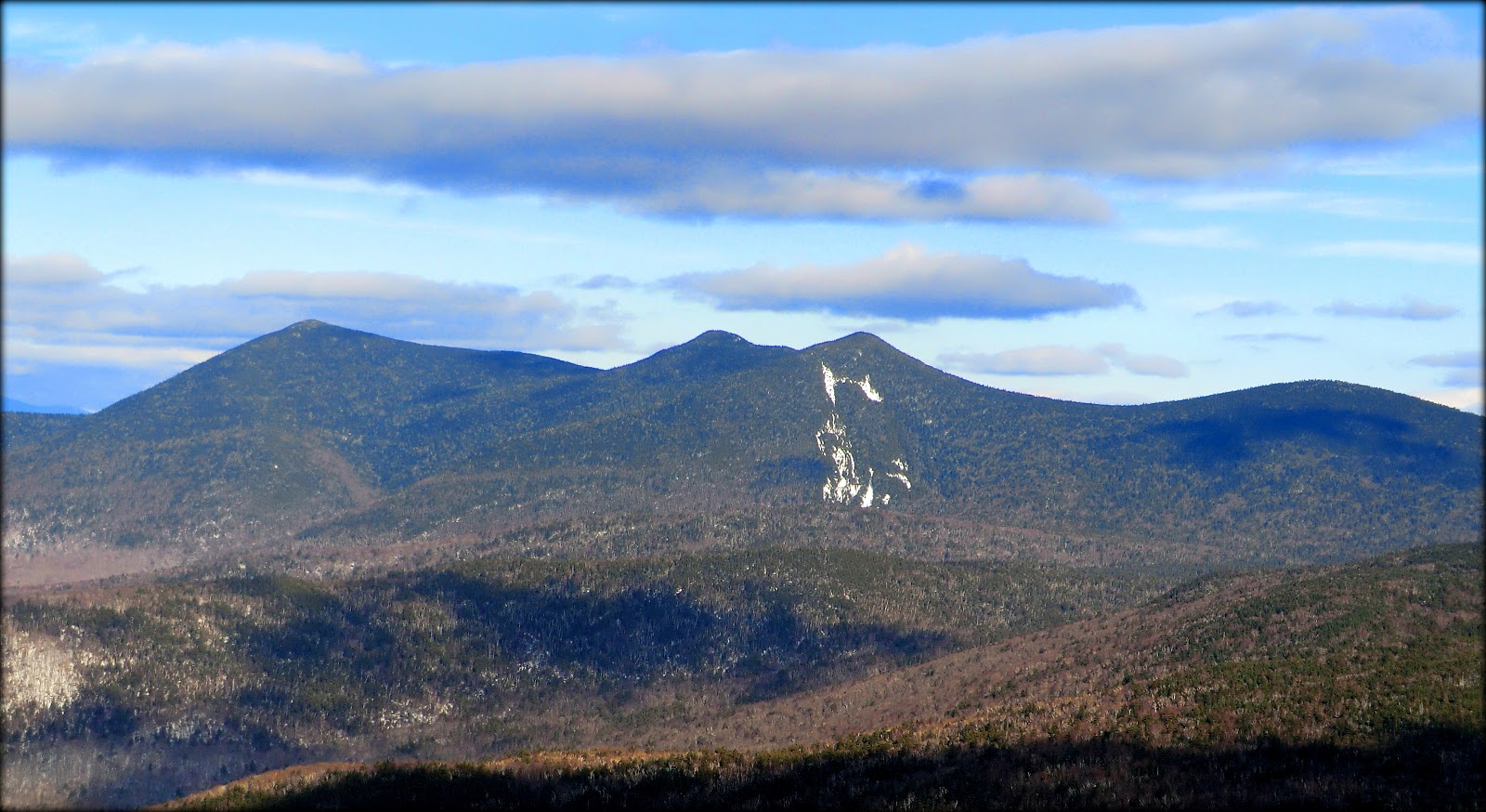
When I came to the spot along the trail where an old logging road veers sharply to the east, I did as I've done in the past and followed that road to the viewpoint which is mentioned above (and is labeled on the map shown earlier).  While travelling to this viewpoint, there is a meadow which provides a picturesque vista of Cherry Mountain's southern ridgeline.
ve
Cherry Mountain's southern ridgeline, as viewed from a meadow
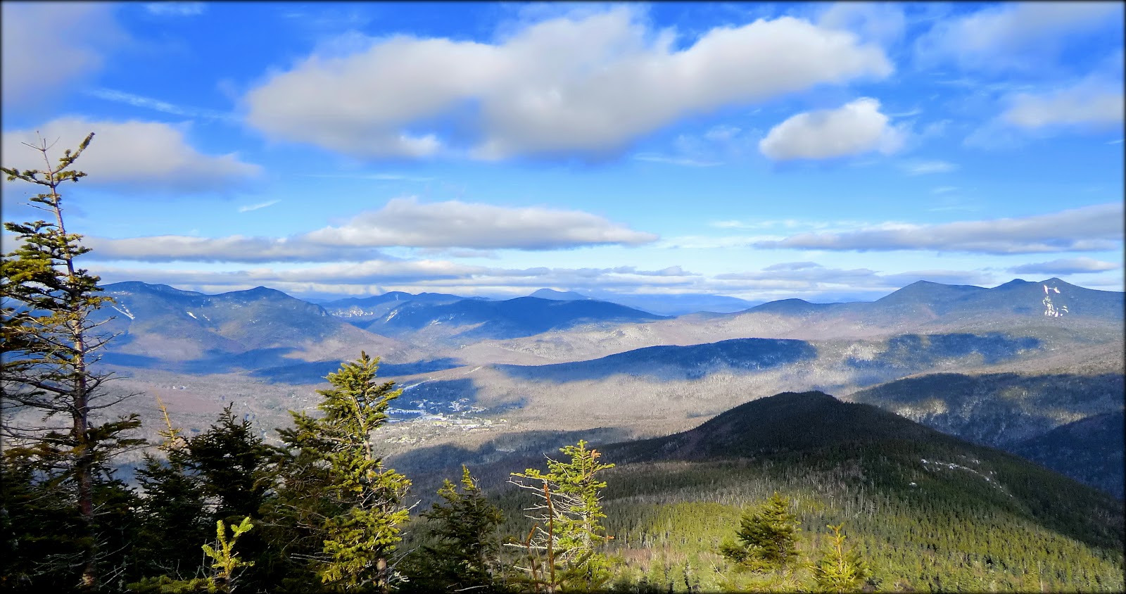
Upon arrival at what I'll call the main viewpoint, there is a nice southward vista looking toward the Twins and the Franconia Range (see photo below).
Twins and Franconia Range as viewed from a spot located off the old Black Brook Trail
After my visit to the viewpoint, I returned to the point where I'd left the Black Brook Trail.   And so, the second part of adventure began.  In the past, I had never ventured beyond this point since the corridor for the old Black Brook Trail is very obscure at this particular spot.  However, with a bit of meandering zigzags,  I was able to locate the corridor which then remained obvious all the way to point where I stopped.

My stopping point for this trek is labeled on the map presented earlier.  From the outset of this hike, I had no preconceived notions as to how far I would trek along the old Black Brook Trail.  And actually, I was unsure if it would even be possible to find the old corridor!  Regardless, once I found it, I simply enjoyed hiking on it until I reached my turnaround time for arriving back at my car before nightfall.

I took a GPS waypoint at my stopping point.  At some point when I'm hiking the eastern portion of the Cherry Mountain Trail, I might diverge from that trail and hike down to my stopping point.  If you know where to look, the old Black Brook Trail is quite obvious at the point where it joins the Cherry Mountain Trail.

You might ask, just how obvious was the portion of the old Black Brook Trail that I followed when venturing beyond the 1.5 mile mark?  Well, as the saying goes, a picture is worth a thousand words.  So, just for good measure, shown below are two pictures.

The first photo shows the corridor, along with one of the yellow blazes.  These blazes are few in number, but just enough to provide reassurance that you are actually on the old trail.  The second photo shows evidence of past trail maintenance along the corridor.
Black Brook Trail corridor, along with one of the very few remaining blazes
Evidence of  past trail maintenance along the Black Brook Trail
Lots of moose poop was seen along the route.  Also, I saw a bird's nest that was positioned low to the ground, and directly at the edge of the trail's footway.   Maybe some knowledgeable reader can enlighten me as to the type(s) of birds that might build their nest at such a location.
Lots of moose poop was seen along the route
Bird's nest seen right next to trail corridor and down low to the ground
It was getting late as I was making my way back to my car.  I was surrounded by woods and therefore was unable to see any alpenglow on the mountainsides.  However, as I looked overhead, there was a definite reddish-golden glow that was illuminating the treetops.  I can only imagine what it must have looked like on the slopes of the surrounding mountains.
Late evening in the woods as the sun was setting
Before concluding this report, I should mention that (in my opinion) the abandoned Black Brook Trail is just marginally suitable for summer travel.   I once tried hiking this route during that season of the year.  The footway had many spots that were wet/boggy, and briar patches were encroaching into the trail's corridor.  And to top things off, I was covered in ticks!!  For those reasons, I think it's best enjoyed in late autumn and during the winter season.

To sum it up, this was a very enjoyable snowshoe trek spent meandering along an abandoned hiking trail.   I love this type of easygoing roaming with simple goals in mind.

22 January 2013

A Winter Trek to Blueberry Mountain in the Benton Mountain Range


The Benton Range is a collection of six low-elevation mountains, none of which attain even a 3K status.  These mountains are: Jeffers Mountain (2,994 ft); Black Mountain (2,830 ft); the Hogsback (2,810 ft); Blueberry Mountain (2,662 ft); Sugarloaf Mountain (2,609 ft); Owls Head (1,967 ft).  Other than Owls Head, I've visited all the mountains in this range.  This involved some bushwhacking since Black Mountain and Blueberry Mountain are the only two peaks in this range that have maintained hiking trails.

The hike that is the subject of this report was launched from the east terminus of the Blueberry Mountain Trail which is located on Long Pond Road near the small settlement of Glencliff, NH.  On several occasions I've hiked to Blueberry Mountain via this approach route.  Therefore,  this would not exactly be a new hike for me, but it was "new" in the sense that it would be the first time I've been on this trail since the logging operations have come to an end at that location.  I was curious to see the impact of those operations on the trail corridor.

Although the trek to the top of Blueberry Mountain is only 1.7 miles from the trailhead, in the winter months you need to tack on about another 0.6 miles since Long Pond Road is closed to vehicular traffic during the wintertime.  There are several option for parking during the winter months.  You can park at the point where Long Pond Road is gated, but this can be a tricky proposition, and I personally would advise against doing so unless you have a 4WD/AWD vehicle equipped with snow tires.  The other two parking options are: a plowed bump-out on the shoulder of High Street (adjacent to High Street Cemetery); or the trailhead parking lot for the Glencliff Trail.

After walking the approximate 0.6 miles (mostly uphill) along Long Pond Road, I came to the trailhead for the Blueberry Mountain Trail.
Trailhead Sign for Blueberry Mountain Trail

Beginning at the trailhead, you hike along a logging access road for a very short distance (only about 5 minutes), and then the hiking trail splits off to the right.  The snapshot below shows this departure point.
Point where hiking trail departs logging road

You will also note in the photo shown above that there is only a light covering of snow on the hiking trail.  As you might suspect, there is a more of a snow cover as you gain elevation.  However, on the day of my hike, you really could have done this entire trek without snowshoes.  However, I wore them anyway since they provided a more stable platform on an uneven surface.  Plus, I kept thinking that as soon as I stopped to remove them, then it wouldn't be long before I'd need them, which would involve stopping again to put them back on!

The hiking trail weaves its way through the various logging cuts, as shown in the Google Earth image presented below.  Although the imagery date for this satellite view is November 2011, I think it's a fair representation of what currently exists.
Google Earth imagery of logging cuts on either side of Blueberry Mountain Trail

As can be seen from the image shown above, there is a wooded buffer between the hiking trail and the logging cuts.  However, especially at this time of year when the leaves are down, you can clearly see some of these cuts from the trail.  In an attempt to put a positive spin on this, if you care to venture a short distance off-trail, these clearings do provide some views, such as shown below in the next photo.
View of South Peak area of Mt. Moosilauke from logging cut off the Blueberry Mtn Trail

But of course the best views are from the ledges higher up on Blueberry Mountain. And particularly nice is the vista of Mt. Moosilauke, as shown below.
Mt. Moosilauke as viewed from ledges on Blueberry Mountain

And shown below is a zoomed view of Mt. Moosilauke.
Zoomed view of Mt. Moosilauke

The next series of photos show some other mountain vistas that can be seen from the ledges on Blueberry Mountain's east side.  (NOTE:  As always, I won't be offended in the least if a reader corrects me on features that I've misidentified.)
Carr Mountain

Wachipauka Pond/Webster Slide Mtn (foreground) + Mt Cube ledges (upper right horizon)

Zoomed photo of Wachipauka Pond/Webster Slide Mtn

In addition to visiting the ledges on the east side of Blueberry Mountain, I continued for a short distance along the trail to the west side of the mountain.  Along the way there is a huge cairn.  Perhaps a reader can enlighten me as to the reason for its large size.  I know for certain that it's NOT located at the summit of Blueberry Mountain.  The only thing I can figure is that since the trail does begin to descend at this point, perhaps this cairn marks the high point of the trail itself?
Large cairn located on Blueberry Mtn Trail (perhaps it marks highest point of trail??)

Regardless of the purpose of the large cairn, as I began descending the west side of Blueberry Mountain, it wasn't long before I came to a spot where there was a vista of three of the other peaks in the Benton Range.  This vista is shown in the next photo.  From left to right, you can see the ledges on Sugarloaf Mountain, Black Mountain, plus a small sliver of the ledges on the Hogsback (just below and slightly to the right of Black Mountain).
Sugarloaf Mtn; Black Mtn; the Hogsback (as seen from ledges on west side of Blueberry Mtn
  
And of course, what's a visit to Blueberry Mountain without a photo showing some of the blueberry bushes!  Shown below is close-up snapshot of one of the countless number of blueberry bushes on this mountaintop.
Close-up snapshot of blueberry bushes on Blueberry Mountain

On my way back down the mountain, I stopped to take a zoomed snapshot of the Glencliff Home which was visible through the trees.  This facility is nestled on the side of Mount Mooselauke. Its goal is to provide a continuum of services for New Hampshire's developmentally disabled, and/or mentally ill population in a home-like atmosphere.
Glencliff Home as viewed through the trees during descent from Blueberry Mountain

Then, once I arrived back at the spot where I'd parked my car, I decided to walk a few more steps to take a look at the High Street Cemetery which is listed on the New Hampshire State Register of Historic Places.  This cemetery is the last remaining resource that conveys the history of the town’s early High Street area settlement, which was bypassed by most industry and transportation. Stories of the pioneers who settled this remote and rugged area are told by the cemetery’s 46 grave markers, the oldest of which dates to 1812 and the newest to 1877.
 Photo collage of historic High Street Cemetery

To sum it up, even though this venture wasn't a new hike for me, it was "new" in the sense that it provided the opportunity to check out the east side of the Blueberry Mountain Trail following the logging operations that have recently ended.  Despite the logging cuts made on the side of the mountain, I can say that Blueberry Mountain remains as a worthy destination for a short hike at any season of the year.

16 January 2013

A Modest Goal: Jennings Peak via a Trail That Was New for Me


As many readers of my Blog know, I try to do something that is new to me for each of my treks.  I don't always succeed in achieving this goal, but do take every opportunity I can to make it happen.

When trying to decide where to hike on 15-Jan-2013, out of the blue it occurred to me that I had never hiked the segment of the Sandwich Mountain Trail between the trailhead and the junction with Drakes Brook Trail.   And even though I'd been to Jennings Peak (3,460 ft) on several occasions, going there via the Sandwich Mountain Trail would be a new experience for me.

My modest goal for this particular day would be merely to hike to Jennings Peak.  That would be my final destination.  There was no desire to go onward from there to Sandwich Dome.  I have visited that mountaintop many times via a couple of routes.  My most memorable trip to Sandwich Dome was a loop hike involving a bushwhack, as well as the Smarts Brook Trail, along with portions of the Algonquin and the Sandwich Mountain Trail. (Click HERE to read about that adventure.)

Within a few hundred feet of the trailhead, the Sandwich Mountain Trail crosses Drakes Brook.  It is the only water crossing on this trail.  On the day of my hike, the crossing was tricky, but doable.  I knew that if it was beyond my comfort level, then I could always utilize the option mentioned in the White Mountain Guide which states: ". . . you can reach the trail on the other side of the brook by bushwhacking up the west bank from where Drakes Brook crosses under NH 49."

Shown below is the Drakes Brook crossing as it appeared on the day of my hike.  The route I took across the brook is highlighted in pink.
 Crossing of Drakes Brook

According to a booklet by Guy Waterman entitled "An Outline of Trail Development in the White Mountains 1840-1980", the Sandwich Mountain Trail has been around since 1879.  When walking corridors as old as this, one cannot help but have thoughts about all the hikers who have traipsed along this trail over the past 130+ years, and all the tales that could be told about those many adventures.

Regardless, the story of my adventure is really rather mundane.  The snow on the trail's treadway was well consolidated by hikers who had kindly used snowshoes to break out the trail.  The recent January thaw had further hardened the treadway such that I was able to comfortably use Microspikes for the entire trek.  I did have my snowshoes strapped to my pack, but they just got a free ride.  They never left my pack since there was no risk of post-holing at any point along the way.

The next photo collage just shows a random selection of a few of the features that I came upon while hiking the trail to Jennings Peak.
Random selection of features along the trail to Jennings Peak

Besides the views from the top of Jennings Peak,  there are a number of other vistas that are available from the Sandwich Mountain Trail itself, as you work your way up the mountain. The series of six snapshots shown below is a collection of trailside vistas, as well as views seen from the top of Jennings Peak.   

None of these photos fall into the category of "knock your socks off", but they do provide an idea as to the scenery that was experienced on this hike.  One thing that is apparent in all these snapshots is the pathetic lack of snow, especially for northern NH in mid January.  I think the lack of snow on tree branches makes things look more snow barren, particularly in the photos of distant vistas.
Sweeping vista looking over Waterville Valley (Osceolas to Tripyramids)

Zoomed view of Mad River Notch

Zoomed view of Tripyramids

Zoomed view of Mt. Washington

Rocky "bumps" along the Acteon Ridge

 Looking up at Sandwich Dome Mountain
To sum it up, even though I have visited Jennings Peak on other occasions, revisiting this location was made special by hiking a trail that was new to me.  It also happened to be a good fit for the type of hike I was seeking on this particular day.  I wanted something that wasn't too long, nor too short.  Jennings Peak was "just right".  Call it a "Goldilocks" hike, if you will. :-)

08 January 2013

From Crawford Notch to Bartlett: Two XC-Ski Adventures


After having lived in Bethlehem for nearly 10 years, I'm still amazed at how much beauty you can experience even with just a few short hours of outdoor activity.  On a recent Monday (07-January), it was gloomy and spitting snow.  However, the weather forecast said it would become sunny later in the day.  I frittered away a good part of the morning waiting for the weather to clear, and weighing my options for an outdoor adventure.

By late morning I grew weary of waiting for the weather to make up its mind, and so I made up my mind!  I strapped my snowshoes onto my pack, gathered my XC skis and poles, jumped into the car and headed in the direction of the Crawford Notch.   The sky was overcast all the way down Route 302 from my home to the top of the Notch.  But, as frequently happens, weather conditions became better at the south end of the Crawford Notch and onward toward Bartlett.

PART 1: Crawford Notch

With the clearing sky, my first stop of the day was at the parking area at the Willey House Site.  My goal was to XC-ski along the Sam Willey Trail to a viewpoint at the end of that trail, and then continue skiing southbound along the Saco River Trail.  I kept my snowshoes strapped to my pack.  I knew from previous experience that it's a good option to be able to hide your skis in the woods and change your footwear to snowshoes.  On this trek, having this option would make it easier to do some off-trail maneuvering to reach a wetlands area off the Saco River Trail. 

And so, here are a few snapshots of things that I saw on the Crawford Notch segment of my two-part journey for the day.

At the end of the Sam Willey Trail is a nice view looking northward toward the massive south-facing cliffs of Mt. Willard.  (As you'll see in the left portion of the following photo, there was still a tad of lingering mist that had yet to clear out.)
Looking northward up Crawford Notch toward massive south-facing cliffs of Mt. Willard

In the photo shown above, you can see a small portion of the two large mountains on either side of the Crawford Notch. (Mt. Willey on the left, and Mt. Webster on the right.)  The next two snapshots provide a better idea of the size of these mountains which form the two walls of the Notch.

The following snapshot of Mt. Willey was taken by doing a snowshoe bushwhack to a wetlands area located a short distance off the Saco River Trail.
Mt. Willey as viewed from wetlands area a short distance off the Saco River Trail 

The next snapshot shows a portion of Mt. Webster.  Capturing the entirety of the Mt. Webster ridgeline wasn't possible from any vantage point along my route for this particular day.
 A portion of the Mt. Webster ridgeline

The following snapshot from my Crawford Notch ramble shows a scene along the partially frozen Saco River.   If you look closely at the top center portion of the photo, you can see the remains of a bridge abutment.  As I understand it, there once was a road that crossed the Saco River at this point to provide access to campsites along the east side of the river.
Partially frozen Saco River with portion of old bridge abutment visible at top center of photo


PART 2: Stillings Road

With still a few hours remaining in the day, I decided to continue driving southward down Route 302 to Stillings Road.  This is a place in Bartlett that I had first visited in early May of 2012 when I incorporated this roadway into a loop hike involving Mt. Pickering and Mt. Stanton.  To read a report of that Springtime adventure, please click HERE.

To access Stillings Road, you make a turn off Route 302 onto Allen Road, then follow that road for about 0.3 mile until it veers sharply to the right and becomes Rocky Hollow Road.  At this sharp turn, there is usually room (off the shoulder of the road) for 1 or 2 cars to park.  Although there are no signs, Allen Road eventually morphs into Stillings Road at the point where the USFS land begins.  Both Allen Road and Stillings Road are public roads.  However, the land on either side of Allen Road is private land.  The land on either side of Stillings Road is generally public land, but there are a few private seasonal camps scattered along the roadside here and there.

The following map shows the location of Allen Road and Stillings Road. (Click to enlarge.)
Map showing location of Allen Road and Stillings Road

Stillings Road generally follows the old rail bed for the Rocky Branch Railroad (RBRR) which was used for logging operations (1908 to 1914).  The following snapshot shows a section of the corridor where the old rail bed is particularly apparent.
Portion of Stillings Road where old RBRR bed is particularly apparent

This public roadway is ideal for XC skiing.  Being mostly an old railroad bed, it is predominately flat.  And although snowmobiles occasionally travel along this corridor, it is not a snowmobile route.  Also, the woods on either side of the corridor are fairly open which makes for some great off-trail gliding to investigate the shoreline of the Rocky Branch River, or whatever might strike your fancy.

I'm uncertain about the exact mileage, but at about 1.5+ miles up Stillings Road is the abandoned Stillings Farmhouse.  I'm attempting to get more information about this structure.  Any additional information that is obtained will be included as an addendum to this report.  For now, suffice it to say that Stillings Road was named after the Stillings family who once lived along this road.

Shown below is a snapshot of the abandoned Stillings homestead (see ADDENDUM at bottom of this report).  Back in the day, the family must have had a magnificent view of Iron Mountain while sitting on their front porch.  Iron Mountain can be seen through the trees being illuminated by the late afternoon sun.

Abandoned Stillings homestead with Iron Mtn being illuminated by late afternoon sun

Part 3: My trip back home

Okay, I said at the beginning of this report that my adventure for this day consisted of only two parts.  Well, there was a third unanticipated part that happened on my way home when I experienced two occurrences of alpenglow! For anyone who is unfamiliar with the term "alpenglow" it's a phenomenon which can occur when the sun is just below the horizon and a reddish glow is cast upon the opposite horizon.  Alpenglow is easiest to observe when mountains are illuminated, but can also be observed when the sky is illuminated through what is known as backscattering.

While travelling northbound on Route 302, I noticed a glow in the sky as I approached the Scenic View pull-off near the trailhead for Arethusa Falls.  I steered my vehicle into this area and did my best to photographically capture the view.  Although the "in-person" experience was better than what is shown below, perhaps this zoomed photo will provide an idea of the alpenglow being cast upon the Presidential Range.
Alpenglow on Presidential Range

Then, a few minutes later, as I approached the same Willey House Site area where I had parked earlier in the day, I experienced a second alpenglow event!  The very top of Mt. Webster's ridgeline appeared to be ablaze!  The lower portion of the mountain was "shielded" from the alpenglow by the sheer bulk of Mt. Willey just across the Notch to the west of Mt. Webster.  The next photo will perhaps provide some idea of what I saw.  As with the earlier experience, the alpenglow was more dramatic when viewed in-person.
 Alpenglow atop ridgeline of Mt. Webster
 
To sum it up,  my XC-ski adventures are just a few examples of the beauty one can experience  in the White Mountains of New Hampshire, even with just a few short hours of outdoor activity.

/////////////////////////////////////////


ADDENDUM (Added 13-Jan-2013):
 
A debt of gratitude is owed to Mike Dickerman (author and White Mountain historian) who provided me with the following information relative to the old Stillings Farm.
 
"In the book, The Latchstring Was Always Out: A History of Lodging Hospitality and Tourism in Bartlett New Hampshire by Alieen M. Carroll, there are a couple of pages of text regarding the Stillings family and their farm.  Peter Stillings, who came to town in 1796, was the original owner of the farm.  At some point he sold off half the land to his son, Peter, who apparently ran a farm and small inn.  He, in turn, sold his land to his son, Nicholas, who would build the Upper Bartlett House on the same property.  Incidentally, Peter Stillings was also among the "rescue" party that headed to Crawfiord Notch in August 1826 to determine the fate of the Willey family. That's just a brief history of the Stillings clan. If you want more info, I'd try and get a hold of the aforementioned book."


02 January 2013

New Year's Day on a New Trail


On New Year's Day (2013), I slapped on my XC skis and tried out a new XC-ski trail.  David Govatski (President, Friends of Pondicherry) recently made me aware of work that is being done to develop this new trail at the Pondicherry Division of theSilvio O. Conte National Fish and Wildlife Refuge.  Additional work needs to be done before this trail is formally opened (tentatively scheduled for October 2013).  However, I was invited to try out the trail in its current condition.

The trail corridor utilizes old logging roads.  Some of the work remaining to be done includes remedying issues associated with 15 ditches that bisect the trail.  About half of the these ditches have standing water even when the air temperature is below freezing.  The hazard is that skis can get wet which means having to stop and remove the ski to wipe it dry and scrape off the snow/ice build-up. With some careful maneuvering, I successfully avoided all but one of these wet spots on the outbound leg of my trek.  On the return leg, I avoided all of them.

I'll "cut to the chase" and say that I am thoroughly impressed with this 1.6 mile trail which is slated to be named the Mooseway XC-trail.   Although the Mooseway is designed primarily as a XC-ski trail, the intent is to allow snowshoe traffic as well.  This new trail will provide a non-motorized alternative to people seeking a visit to Cherry and Little Cherry Ponds without any snowmobile traffic.

The Mooseway is accessed from the Mud Pond Trailhead off of Route 116 in Jefferson where there is a large parking lot which is plowed for winter use.  The trail begins a short distance from the Mud Pond trailhead at the point where the Mud Pond Trail makes a sharp right turn.  The Mooseway ends at a junction point along the Little Cherry Pond Trail, about 0.2 mile east of Little Cherry Pond.

Perhaps the following map will provide a better idea about the location of the Mooseway XC Trail.
Map showing general location of Mooseway XC-Trail corridor

And so with that rather lengthy introduction, here are some snapshots taken during my XC-ski adventure which included skiing along the Mooseway XC-Trail, as well as the Little Cherry Pond Trail, plus the Rampart Trail which runs along the shore of the larger pond which is simply known as Cherry Pond.

The next two photos show scenes from the Mooseway XC-Trail which leads you through sections consisting of mixed hardwoods and conifers, as well as through a beautiful section consisting entirely of spruce.
Segment of Mooseway XC-Trail leading through mixed hardwoods and conifers

Segment of Mooseway XC-Trail leading through a beautiful spruce forest

Once you reach the Little Cherry Pond Trail, you have the option of turning right and trekking down to Little Cherry Pond, or you can go turn left and head for Cherry Pond.  I opted to go left and take in the views from the shoreline of Cherry Pond.  Then, as part of the return leg of my adventure, I would pay a visit Little Cherry Pond.

The eastern end of the Little Cherry Pond Trail terminates at a rail corridor.  The next photo shows the rail corridor, but it was taken from a point slightly south of where the Little Cherry Pond Trail intersects it. 
Rail corridor as viewed from a point slightly south of where Little Cherry Pond Trail intersects it

The Rampart Trail is directly across the railroad tracks from the eastern terminus of the Little Cherry Pond Trail.  This trail provides access to excellent views from the western shore of Cherry Pond.  The vistas that I find particularly appealing are those of the Presidential Mountain Range, and Cherry Mountain.

A persistent cloud cover partially obscured the Presidential Range, as can be seen in the next two photos.
Cloud-covered Presidential Range as viewed from shoreline of Cherry Pond
Slightly zoomed view of cloud-covered Presidential Range

Although the vista of the Presidential Range was partially obstructed by clouds, Cherry Mountain was fully visible with all its shapely beauty.  The sharply-pointed Owl's Head peak on the northern end of the mountain is particularly prominent.
Cherry Mountain with pointed Owl's Head peak particularly prominent

As stated earlier in this report, on the return leg of my trek, I made a short side trip to Little Cherry Pond.  The sun was low in the sky by the time I arrived, which made it difficult to  take snapshots that were particularly flattering to this body of water.  Shown below is a photo looking toward the pond's northern shore where the sunlight wasn't a factor.
Looking toward northern shoreline of Little Cherry Pond

As I neared the end of my adventure for the day, the sun was about to dip below the horizon.  As I looked behind me while skiing along the Mooseway, there was a nice vista of Cherry Mountain being illuminated by the setting sun.
Cherry Mountain viewed from Mooseway XC-Trail at sunset

And then, as I turned to look westward, the sky was being "colorized" with shades of orange and yellow.
 Western sky at sunset, as viewed from Mooseway XC-Trail

To sum it up, when fully completed, the Mooseway will offer an excellent opportunity for XC skiers and snowshoers to experience remote sections of the Pondicherry Wildlife Refuge.