Pages

About Me

My photo
Bethlehem, New Hampshire, United States
E-mail contact: randonneur8@yahoo.com | Facebook: facebook.com/1HappyHikerNH

Text Above Search Box

SEARCH MY BLOG USING TEXT BOX SEEN BELOW:

31 January 2012

Trekking to Shell Cascade and Other Locations During a Low Snow Season

You've heard the expression "If you can't beat them, join them!"   That's sort of typifies the philosophy I've been following during this winter in which there is very little snow at the lower elevations in NH, and many other New England locations.  At many places where I would enjoy XC-skiing during a typical winter, there either isn't enough snow and/or it's too icy.   
And so, I figure that if can't ski them, then walk them!

There is probably very little that would be of general interest for many of my walking forays along those corridors where I'd normally be skiing.  But occasionally, there are some exceptions.  In this Blog report, I'll describe two adventures that might be mildly interesting to a few readers.

1) Shell Cascade (Waterville Valley area)

When looking at maps of the Waterville Valley area, I've often been curious about a geographic feature that is labeled as Shell Cascade. (Click on the map snippet below to enlarge it.)

There are no hiking trails that lead to Shell Cascade.  And, from a very cursory search of a few editions of the White Mountain Guide (WMG) books from the early 1900s, it appears that there wasn't a trail even in that early timeframe.   I did find a brief description of a path leading to Shell Cascade in the 1892 book by A.L. Goodrich entitled "The Waterville Valley, a History, Description, and Guide".  The snippet below shows this description in its entirety.

I would need to read this book more carefully to determine the location of the "House" that is mentioned as the starting point for a  trek to the cascade.  But regardless of the location of the house, it appears that it was a 4.25 mile journey to the cascade.  Although I'm uncertain, I presume that was one-way, versus round-trip?!

In the 1990s, Bruce, Doreen, & Daniel Bolnick published a book entitled "Waterfalls of the White Mountains". Shown in the snippet below is the total description of Shell Cascade as described in the Bolnick's book.

I'm assuming that the bushwhack described by the Bolnicks involves fording the Mad River.  I suppose at certain times of year the current and water level must be low enough to safely allow this, and perhaps there are some winters when there are ice dams that are firm enough to permit safe passage across the river.
 
Regardless, on 30-January, conditions were definitely unsafe for crossing the Mad River!  Therefore, I opted to launch my trek to Shell Cascade from FR116 and follow that corridor to a point near the cascade.  Eventually, I'd leave this corridor to do a short bushwhack to reach the cascade.  The entire trek was done on public land.  The map shown at the beginning of this Blog shows where I parked.

In a typical winter, FR116 is a terrific corridor for XC-skiing.  However, the light snow cover on this forest roadway had been transformed to crusty snow and ice by recent rain events.  Conditions were horrid for skiing, but it was relatively easy trekking with the use of Microspikes, and eventually snowshoes for the bushwhack portion of my hike.

It took just over an hour (one-way) to reach the cascade.  The overall distance was about 2-miles (road + bushwhack combined).  I found the cascade on Hardy Brook at the elevation stated by the Bolnicks, i.e. at about 1,350 ft.  However, as would be expected on a January day, much of the "cascading" was hidden from view by the layers of ice.  But, I fully intend to make a return visit in the Springtime to see this cascade in its full glory!

The snapshot below shows the condition of the frozen cascade on 30-January.

And, the next photo shows Hardy Brook just below Shell Cascade.

Besides the pleasure of finding Shell Cascade, the overall journey was surprisingly enjoyable as well.  Sometimes, it can be a rather boring experience to trek along a forest road such as FR116 which has been used for logging operations in the past.  However, enough time has passed to allow some "healing".  There are large stretches of the roadway that now somewhat resemble a hiking trail, albeit a very wide trail as seen in the next photo.

Also, I know it's a bit like cheating, but there are some respectable views from some of the areas that were clear-cut and have not fully grown in.  Some of these views are shown in the next two snapshots.  The first one is looking at Noon Peak and Jennings Peak.  In the second photo, the south peak of the Tripyramids is seen on the horizon.   It's weird that these photos somewhat resemble a scene from late Autumn.  But I think this is merely due to the presence of beech trees which generally hold onto their leaves through the winter.
    

So, that was my Shell Cascade adventure.  The following exploit, which was done a few days prior, is very marginal in terms of sparking any keen interest.

2) Beaver Brook XC-ski Trails (Twin Mountain area)

Unlike my Shell Cascade trek, this hike was done entirely on a trail system.  It just so happens that this particular trail system is designed for XC-skiing.  But, as indicated earlier, the snow conditions are poor.  There was no evidence of any ski traffic on these trails!!  The snow cover is simply too thin, and the surface is too icy.
 
Unless you've skied this trail system, the names of the trails are probably unfamiliar. One of the trails I walked was the Moose Watch Trail.

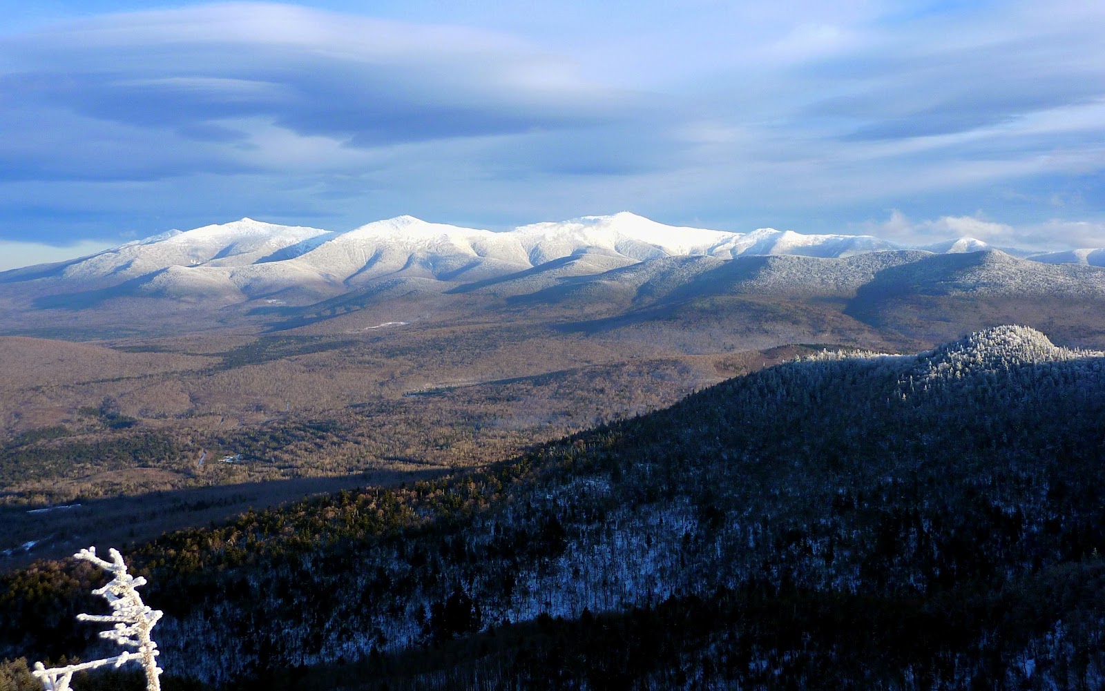
From the Moose Watch Trail there is a nice view of Mt. Garfield and the Franconia Range, as seen in the next photo.

The other thing that I found interesting about this trek was the bright red color of the tree saplings that are seen in the next photo.  Perhaps someone who is more woods-wise and horticulturally-inclined than me can answer this question.  Isn't it a bit early for this red color to be appearing?  I thought this normally started to occur in late February.

To sum it up,  it would be wonderful if we were experiencing a typical New Hampshire winter.  However, despite the icy conditions and thin snow cover at the lower elevations, there are some interesting treks that can be done in those areas where you would normally be enjoying a nice XC-ski outing.  As indicated at the beginning of this Blog, you might consider adopting a philosophy based upon the adage of "If you can't beat them, join them!"   In other words,  if can't ski them, walk them!

26 January 2012

Mt. Parker - Great Views!

Mt. Parker!  It's not a mountain that comes to mind as readily as the names of New Hampshire's 4K peaks.   As a matter of fact, Mt. Parker barely makes it as a 3K peak with an elevation of only 3,004 ft.  For anyone unfamiliar with the location of Mt. Parker, it is situated nearly due north of the village of Bartlett, NH.  It's on the southeast edge of the Presidential Range Dry River Wilderness, and is the southernmost 3K peak on the main branch of the Montalban Ridge.

The shortest route to Mt. Parker is to use the Mt. Langdon Trail to link up with the Mt. Parker Trail.   This route entails a round-trip distance of 7.8 miles with a total elevation gain of 2,800 ft.   That round-trip distance and elevation gain is far greater than many of the 4K peaks, such as Mts. Osceola, Tecumseh, Hale, Jackson, Pierce, and Tom.  Even a round-trip trek to Mt. Eisenhower via the Edmands Path is only 6.6 miles with an elevation gain of 2,750 ft.

Perhaps the distance and elevation gain involved for a mere 3K peak is part of the reason for this mountain's lack of popularity.   Another possible deterrent is the fact that there is no practical way to include Mt. Parker as a part of a loop hike.  It is an out-and-back hike via the same route.  Plus, you need to ascend and descend Oak Ridge on the way to Mt. Parker, then ascend and descend this ridge again on the return leg of the hike.   A sizeable chunk of the elevation gain for this hike results from ascending this ridgeline twice!

Whatever the reason for this mountain's lack of fame, it surely cannot be due to the lack of spectacular views in all directions.  By far, the most striking view is looking northward up the Montalban Ridge and Rocky Branch valley toward Mt. Washington and the southern Presidentials.  On my trek to Mt. Parker on 26-January, I took photo after photo of this particular view.  A selection of these snapshots are shown below.  Some are un-zoomed, whereas others are slightly zoomed, and one is a highly zoomed shot of Mt. Washington.


Besides the awesome view northward toward the Presidential Range, there are other views to the south, east and west that have a beauty of their own.  Some of the more recognizable peaks and mountain ranges that can be seen include Mt. Resolution, Mt. Crawford, peaks in the Willey Range, the Twin Range, the Nancy Range, Mt. Carrigain, the Osceolas, Mt. Tremont, the Tripyramids, Mts. Whiteface, Passaconaway, and Chocorua, as well North Moat, the Wildcats, Carter Dome, peaks in the eastern Mahoosucs, the Baldfaces, the Doubleheads, plus Iron Mountain and Kearsarge North. 

The next set of photos show just a small selection of some of the views mentioned above.


Way off in the distance, the westward view even includes the summits of Mts. Lincoln and Lafayette with a bit of Bondcliff showing below.  The next photo is a highly zoomed snapshot of this view which is comparable to what you would see with binoculars.

And speaking of zoomed photos, shown below is a close-up of Chocorua as seen from Mt. Parker's summit.

The trail conditions on 26-January were perfect for snowshoes from trailhead to summit. There were some blowdowns along the route, but all were easily negotiated.  Shown below is a typical section of the trail.

The first mile of the route (from the trailhead for the Mt. Langdon Trail to the boundary for the Presidential Range Dry River Wilderness) has recently been logged.  Although I've hiked to Mt. Parker many times, this was the first time I've done so in the aftermath of the logging. With the snow-covered ground, things don't look too bad.  There are a number of new logging roads diverging from the main roadway that the trail follows, such as shown in the photo below.

At points where it could be confusing as to which way the trail goes, there are signs to direct you.  Also, there is a sign to direct you to Cave Mountain, whereas this spur trail was un-signed prior to the logging.  The composite photo below shows the Cave Mountain sign, as well as a sample of the multiple signs along the mile-long route of the logging operation.

To sum it up,  in my opinion, the trek to Mt. Parker is well-worth the 7.8 miles and 2,800 ft of elevation gain that it takes to get there.   I suppose my only word of advice would be to choose a good viewing day when visiting this little mountain.  It would be disappointing to travel that distance and gain all that elevation and then be unable to see all that Mt. Parker has to offer.

23 January 2012

Abstract Pleasure from Off-Trail Hiking

On-trail hiking provides a means to easily access scenic destinations, and I derive great pleasure from this type of hiking.  Equally pleasing to me is off-trail hiking, also known as bushwhacking.  Some of my off-trail adventures have elements that appeal to a general audience.  However, many of my ramblings are truly of no interest to anyone, and therefore they are not presented in my Blog or elsewhere.
I suppose an attempt could be made to provide vivid and educational narrations about commonplace things that are seen during my off-trail wanderings through the forest, such as a gnarled tree silhouetted against the sky, etc.  Some people (such as Tom Ryan, Ellen Snyder and Steve Smith) have a real talent for writing about such things in a very descriptive and entertaining manner.   Me . . . not so much!
During the winter months, I find off-trail travel to be particularly appealing since the frozen earth provides the opportunity to explore places that are difficult or nearly impossible to access at other times of the year.  In particular, I'm referring to areas that are prone to be mucky and yucky in warm weather months.    As indicated earlier, it's difficult for me to put into words the personal pleasure derived from this type of adventure.   It's like trying to describe why, for example, I might like a blue shirt versus a shirt of another color.  There are some things that you just simply like . . . end of story!
A few days ago, I did an off-trail trek in an area surrounding Pondicherry that would be unreachable at any season of the year, other than winter.  Photographically, there isn't much that I can show which would provide some insight into the enjoyment that was experienced during this trek.   I mean, there were a few "showy" things such as the red berries of the Mountain Ash contrasted against the white snow (photo below).  For certain, this was a delight to the eye.  However, the greater pleasure for me was something that couldn't be captured in a photo, i.e. the inexplicable joy of being atop the frozen edge of a swamp that would be inaccessible at any other time of year.  Go figure!

Of course, it's often possible and even desirable to combine off-trail hiking with an on-trail experience.  To obtain some more conventional views of the Pondicherry area, I emerged from the swamplands at two locations that are accessible by trail and snapped the photos shown below.
Big Cherry Pond and Presidential Mountain Range

Little Cherry Pond

To sum it up, off-trail hiking is perhaps an acquired taste, much like attaining pleasure from drinking coffee.   I find it difficult to describe abstractions, such as the pleasure derived from drinking coffee, or the enjoyment of off-trail hiking.  Therefore, many of my wanderings are unreported.  But perhaps, if nothing else, this article will provide some impetus to consider responsible off-trail hiking as a means to enhance the overall hiking experience.   Even if your photos are few, and you are at a loss for words to adequately describe your off-trail experiences, you'll at least have the pleasant memories in your own mind to reflect upon.


19 January 2012

A Winter Hike to Black Mountain (the one in Benton, NH)

Black Mountain is a common name for mountains, not only in New Hampshire, but other parts of the country as well.  As indicated in the title of this report, Benton, NH is the location of the Black Mountain that I visited on a wintery 19th day of January.  Benton is a small village on the far western edge of the White Mountain National Forest.   On one of the small buildings in town there is a quaint sign which proudly proclaims that you are in Benton, NH (photo below).

Simply because it is a little closer to my home, I opted to use the Black Mountain Trail, rather than the Chippewa Trail.  Anyone who has used the Black Mountain Trail knows that trailhead parking can sometimes be problematic.  The official parking lot is at the end of a 0.2 mile unmaintained road which can be a muddy mess in warm weather months, and impassable in winter months since it isn't plowed.  However, since we've had so little snow this winter, the 0.2 mile segment appears to be passable.  Shown below is the trailhead parking lot with the road leading to it.

But, did I drive down the 0.2 mile segment of road and park at the lot?  Nope, I chickened out, and opted to squeeze into a small spot off the maintained portion of the road at the point where the unmaintained segment begins.

The trail conditions from start to finish were perfect for Microspikes.  There was an inch or two of snow on top of an underlayment of ice.   Presumably no one has traveled this trail for awhile since no human footprints were seen at any point along the route.  Other than a few animal prints here and there, the trail was pristine.  The photo below shows a particularly picturesque segment of the trail where it crosses a small brook.

When I arrived at the point where the Chippewa Trail comes in, there was ample evidence of hikers having used this trail (photo below).

After the Chippewa Trail junction, it is only a hop skip and jump to the top of the mountain.  The next photo shows the top of the mountain!

From the top, there are nice eastward views toward the Kinsmans and the high peaks in the Franconia Range (photo below).

The next photo is a zoomed shot of the Kinsman/Franconia Range view.

Very nearby is the massive hulk of Mt. Moosilauke.   The weather can change very rapidly in the mountains.  When I first arrived, all of Mt. Moosilauke was cloud-free.  However, within a span of 20 minutes or so, the top of the mountain was engulfed in clouds.  These two different views of Moosilauke are shown in the next two snapshots.

Moosilauke -  No Clouds

Moosilauke - 20 minutes later

In addition to the easterly views toward the Kinsman/Franconia Range, and Mt. Moosilauke, there were also westerly views of the Connecticut River Valley that runs between NH and VT.

And, looking overhead from the top of Black Mountain, there was what I considered to be a colorful display of pine cones.  Who needs to go to Florida to see orange-colored fruit hanging from trees?

So, that was my hiking adventure to Black Mountain.  While driving home on Rt. 142, I stopped at a roadside spot about midway between Franconia and Bethlehem.  From here, there is frequently an awesome view of the north end of the Franconia Notch.  Shown below is the view on this particular day.

To sum it up,  the trek to Black Mountain is short (about 5 miles round-trip).  But sometimes, big things come in small packages.  I think this small hike provides a very "big bang for the buck"!  


14 January 2012

A Cold, Crispy and Colorful Day on Cherry Mountain

At last!  Perhaps, just maybe,  our "winter of discontent" is coming to an end!  There were wintery conditions from trailhead to summit.   From start to finish, the temperature was in the single digits, and we enjoyed hearing the crunch, crunch, crunch of our snowshoes for our entire journey.

My friend Marty and I got a late "crack of noon" start on this 14th day of January, but this just so happened to work to our advantage.  As we drove to the Rt. 115 trailhead for the Cherry Mountain Trail, we could see a shroud of cloud on the high peaks.  However, the clouds were beginning to lift by the time we completed our 1.9 mile trek to  the Mt. Martha peak on Cherry Mountain (see photo below).

Despite our late start, we figured we still had ample daylight hours to make the short side trip from Mt. Martha over to the Owl's Head peak.  The Martha's Mile Trail runs along Cherry Mountain's ridgeline for 0.8 mile and provides a connection between Owl's Head and Mt. Martha.  It's an easy 1.6 mile round-trip trek.
There is something you need to know if you've never done a winter hike to Owl's Head via the Martha's Mile Trail.  The final approach to the Owl's Head summit is nearly always very icy.  Although we had Microspikes with us, Marty and I opted to work our way up the steep icy precipice with the traction provided by our MSR snowshoe crampons.  It was a bit dicey!  It would be a good idea to bring your crampons or Microspikes in case you need them for this final approach.
Once we arrived at Owl's Head, the cloud cover had lifted even more (snapshot below).

The clouds continued to lift very quickly, and by the time we'd finished eating a late lunch, the clouds over the mountaintops were really starting to move out.

Our return to Mt. Martha was uneventful . . . well sort of.  Along the way, we spotted something odd.  There must be quite story behind this.  A rope was hanging from a tree branch which I'd guesstimate was about 25 ft off the ground.  Hanging from the end of this rope was a hand mirror.  Go figure!  A snapshot of this odd site is shown below.

By the time we got back to the Mt Martha peak, winter's evening sun was beginning to cast a glow over the mountains.  This is always such a picturesque site!

Adding to the picturesque beauty of this day were the lenticular cloud formations.  There might be a proper term for the particular type of lenticular cloud shown in the next photo, but I'll just call it a "stacked lenticular".

As we headed back down the Cherry Mountain Trail toward the trailhead, the setting sun provided quite a colorful display of light.  We were treated to multihued scenes such as shown in the next photo.

And one of the more unusual scenes is shown below.  It appeared and disappeared all within a matter of 3 minutes or less.  We just happened to be at the right place at the right time to photographically capture this colorfully-illuminated spot along the trail.  No photo-shop tricks were used here.  It is what it is!

To sum it up, gheez . . . it's terrific to have Old Man Winter finally drop by to pay us a visit.  Sure hope he knows that he is appreciated and is most welcome to stick around for awhile!

09 January 2012

Mt Webster (Crawford Notch): Contentment at 4K Minus 90


The "4K Minus 90" in the title of this report refers to the 3,910 foot elevation of Mt Webster which disqualifies it as one of the New Hampshire 4K peaks by 90 feet.  However, this mountain does qualify as being part of the southern Presidential Range, and has the honor of being it's southern-most peak.
My day on 09-January began with uncertainty about whether to hike to Mt. Webster, or to Mt. Jackson, or to both.  I decided to defer this decision until I arrived at the junction where the Webster-Jackson Trail splits to the Webster Branch and the Jackson Branch.
I began the hike with Microspikes and kept them on for the entire trek.  This type of traction device was perfect for the trail conditions which consisted of an underlayment of ice with a few inches of compacted snow on top.
En route to the junction mentioned earlier, I took a brief detour to the Bugle Cliff viewpoint where I enjoyed a nice view toward Mt. Avalon and Mt. Tom.

Upon arriving at the junction for the Webster Branch and Jackson Branch, it was decision time! Do I turn left, or go straight ahead?

From this junction, it is 1.2 miles to Mt. Jackson which is a 4K peak, and it is 1.1 miles to Mt. Webster which is 90 ft shy of being a 4K peak.  I've bagged Mt. Jackson and Mt. Webster on several occasions during the winter and summer seasons.  However, my winter visits to Mt. Webster have been less frequent than my winter visits to Mt. Jackson.  Therefore, I opted to go to Mt. Webster first, and then possibly head on over to Mt. Jackson.
Within a few minutes after setting forth on the Webster Branch, you come to a cascade on Silver Cascade Brook.  There is no "cascading" during the winter months!  Instead, you are treated to a display of blue ice that is quite picturesque.

As you climb higher, you begin to experience that wonderful "winter wonderland" effect where nearly every inch of the trees are cloaked in white.

Hiking to Mt. Webster via the Webster Branch is soooo much easier in winter than summer.   Regardless of whatever season it might be, the trail is still steep.  However, it is much smoother during winter conditions when the snow and ice fill the deep voids between the rocks and roots.  With these ideal conditions, it took less than an hour to traverse the 1.0 mile distance of the Webster Branch Trail to its terminus at the Webster Cliff Trail.
Immediately upon reaching the Webster-Cliff Trail junction I was assaulted by a band of unruly Gray Jays who were demanding to be fed!  Fortunately, I had a small Zip-Loc bag filled with pecans that was readily accessible.  I broke the nuts into smaller pieces and loaded them into the palm of my hand, and then let the feathery bandits have at it! 
Of course, I took some photos to be used as evidence of this banditry (see below).

After awhile, I told the gang they'd had enough and I was going over to Mt. Webster to enjoy the views while having lunch.  I'll swear that those birds understood my words!  I had a winged escort for the entire 0.1 mile trek over to the top of Mt. Webster!  Once I pulled out my sandwich, they insisted that I share it with them.  I really didn't mind sharing my lunch with the Gray Jays.  Others might disagree, but I think they are charming little creatures.
So, after we (i.e. the birds and me) finished our lunch, it was time to decide whether to go onward to Mt. Jackson . . . or not.  After much thought, I decided "not"!  Since it was such a delightful spot, I decided to stay perched on Mt. Webster with the Gray Jay Gang.  There was very little wind, and the air temperature was very mild.  I don't know how accurate it is, but my pack thermometer read 28 degrees (Fahrenheit).
Perhaps some might consider it laziness, or whatever, not to continue onward to Mt. Jackson and thereby conquer a 4K peak in the winter season.  However, I prefer to think of it as contentment!  I was perfectly content to hang-out at my "4K Peak Minus 90" location and enjoy the views on a delightful winter day.
Speaking of views, the next series of photos provide a sample of views at and near the summit area of Mt. Webster.
Looking up the southern Presidential Range

Willey Mountain Range as viewed from a spot near top of Mt Webster

Another view of Willey Range with little Mt Willard sitting down low in the Crawford Notch

Might be one of the rock/ice climbing routes to the top of Mt Webster??

Looking southward toward pointy Mt Chocorua on distant horizon

Looking southeasterly toward ledges on Mt Crawford and Mt Resolution

After I'd had my fill of lovely lounging on Mt. Webster, I packed my things and started the return leg of my trek.  I soon arrived back at the junction of the Webster-Cliff Trail and Webster Branch Trail.
Despite having already decided not to go onward to Mt. Jackson, it was still very tempting since the Webster-Cliff Trail leading to Mt. Jackson was nicely tramped out from hiker traffic.   Going to Mt. Jackson would involve a nearly 4 mile return trek to the trailhead, versus 2.4 miles if I simply retraced the same route used earlier in the day on the outbound leg of my journey.  With less than 2 hours of daylight remaining, I opted to stick with my decision to bypass Mt. Jackson.   And besides, I like nice round numbers.  The round-trip mileage for the route that I followed is a very tidy 5.0 miles!
The descent back to trailhead went quickly and smoothly.  Only one brief stop was made along the way to take a snapshot of Cherry Mountain from a trailside opening.  There is a special fondness for this mountain since I maintain the Martha's Mile hiking trail that runs along the ridgeline and connects the peaks named Mt. Martha and Owl's Head.

Just before getting in my car, I glanced back at Mt. Webster from the trailhead parking lot and snapped a photo.
Yup! It had a been a very good day in the mountains!

To sum it up, although Mt. Webster is 90 feet short of being a 4K peak, it is far from being short on providing a terrific hiking experience.